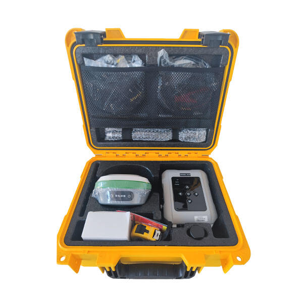
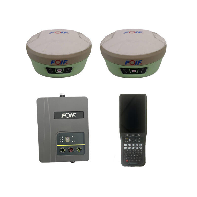
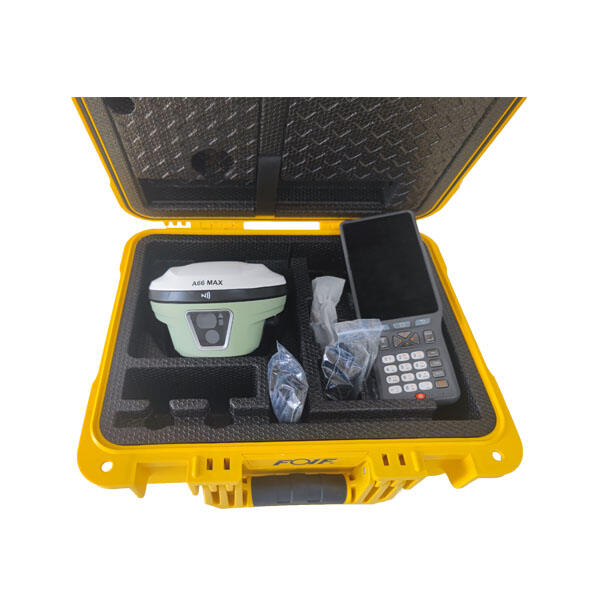
RTK Rover: Professional GPS Surveying Equipment for Precision Mapping and Construction

All Categories

rtk rover

The RTK rover represents a revolutionary advancement in precision positioning technology, transforming how professionals approach surveying, mapping, and navigation tasks. This sophisticated device utilizes Real-Time Kinematic satellite navigation technology to deliver centimeter-level accuracy positioning data in real-time applications. The RTK rover system consists of a portable receiver unit that communicates with base stations or correction services to eliminate satellite signal errors and atmospheric interference. Modern RTK rover units integrate multiple satellite constellation capabilities, including GPS, GLONASS, Galileo, and BeiDou systems, ensuring consistent signal availability across diverse geographical locations. The device features advanced signal processing algorithms that continuously calculate precise position coordinates by comparing satellite signals with reference data from known locations. Built-in wireless connectivity enables seamless data transmission to mobile devices, tablets, or cloud-based platforms for immediate analysis and project management. Professional-grade RTK rover systems incorporate ruggedized housing designs that withstand harsh environmental conditions, including extreme temperatures, moisture, dust, and impact damage. Battery life optimization ensures extended field operation periods, typically ranging from eight to twelve hours of continuous usage. The RTK rover maintains accuracy levels within one to three centimeters horizontally and two to five centimeters vertically under optimal conditions. Advanced user interfaces provide intuitive operation controls, allowing field technicians to configure settings, monitor signal quality, and manage data collection workflows efficiently. Integration capabilities extend to various software platforms, enabling direct compatibility with popular surveying, engineering, and GIS applications. The RTK rover supports multiple data formats and coordinate systems, facilitating seamless integration with existing project workflows and legacy systems.

New Product Recommendations

The RTK rover delivers exceptional value through superior accuracy that eliminates costly measurement errors common in traditional surveying methods. Users achieve consistent centimeter-level precision that reduces project rework and increases client satisfaction across construction, engineering, and mapping applications. Time efficiency represents another significant benefit, as the RTK rover completes positioning tasks up to ten times faster than conventional surveying techniques. Field crews can cover larger areas in shorter timeframes, reducing labor costs and accelerating project completion schedules. The device operates independently without requiring multiple team members for traditional chain surveying or total station operations. Cost effectiveness becomes apparent through reduced equipment requirements, as a single RTK rover replaces multiple traditional instruments while delivering superior results. Organizations eliminate expenses associated with additional personnel, equipment transportation, and extended field time requirements. The RTK rover provides immediate data availability, allowing real-time decision making that prevents costly delays and design modifications during construction phases. Weather independence ensures consistent operation across various environmental conditions, unlike optical instruments that struggle with visibility limitations during fog, rain, or dust conditions. Versatility enables applications across multiple industries, from precision agriculture and construction layout to environmental monitoring and archaeological documentation. The learning curve remains minimal, allowing technicians to become proficient quickly compared to complex traditional surveying equipment that requires extensive training periods. Data integration capabilities streamline workflows by automatically transferring measurements to design software, reducing manual data entry errors and improving overall project accuracy. Remote operation capabilities allow monitoring and control from safe distances during hazardous site conditions or challenging terrain access situations. Long-term reliability ensures consistent performance over years of field use, providing excellent return on investment through reduced maintenance requirements and consistent measurement quality that builds client trust and repeat business opportunities.

Tips And Tricks

Why Do Mapping Teams Prefer RTK for Real-Time Positioning Tasks?

22

Dec

Why Do Mapping Teams Prefer RTK for Real-Time Positioning Tasks?

Modern mapping teams face unprecedented demands for precision and speed in their surveying operations. The evolution of positioning technologies has revolutionized how professionals approach field data collection, with RTK for real-time positioning e...
View More
How Do RTK GNSS Receivers Maintain Stability in Complex Terrains?

22

Dec

How Do RTK GNSS Receivers Maintain Stability in Complex Terrains?

Navigation accuracy in challenging environments has become a critical requirement across industries ranging from construction and surveying to autonomous vehicles and precision agriculture. RTK GNSS receivers represent the pinnacle of satellite-based...
View More
What Should Buyers Compare When Sourcing RTK GPS Equipment?

13

Jan

What Should Buyers Compare When Sourcing RTK GPS Equipment?

Modern construction, surveying, and agricultural operations increasingly rely on precise positioning technology to achieve millimeter-level accuracy in their work. When sourcing RTK GPS equipment, buyers face numerous technical specifications, featur...
View More
How Does a Digital Level Improve Accuracy in Construction Measurements?

13

Jan

How Does a Digital Level Improve Accuracy in Construction Measurements?

Construction professionals understand that precision forms the foundation of every successful project. Modern building techniques demand measurement accuracy that surpasses traditional methods, making the digital level an indispensable tool for contr...
View More

Get a Free Quote

Our representative will contact you soon.
Email
Name
Company Name
Message
0/1000

rtk rover

Unmatched Precision Technology

Unmatched Precision Technology

The RTK rover incorporates cutting-edge satellite positioning technology that delivers unprecedented accuracy levels for professional surveying and mapping applications. This advanced system utilizes sophisticated algorithms to process signals from multiple satellite constellations simultaneously, including GPS, GLONASS, Galileo, and BeiDou networks. The technology corrects atmospheric delays, satellite clock errors, and orbital discrepancies in real-time, ensuring measurement precision within one to three centimeters horizontally and two to five centimeters vertically. Unlike traditional surveying methods that rely on line-of-sight measurements and manual calculations, the RTK rover maintains consistent accuracy regardless of terrain complexity or distance from reference points. The system continuously monitors signal quality and automatically adjusts processing parameters to maintain optimal performance across varying environmental conditions. Advanced filtering algorithms eliminate multipath errors caused by signal reflections from buildings, vehicles, or natural obstacles, ensuring reliable data collection in urban environments or complex topographical settings. The RTK rover features dual-frequency receivers that enhance signal stability and reduce atmospheric interference effects, particularly important during ionospheric disturbances or challenging weather conditions. Quality assurance mechanisms include built-in redundancy checks that validate measurement reliability and alert users to potential accuracy degradation before it affects project outcomes. This precision technology enables professionals to establish control networks, perform boundary surveys, and execute construction layout tasks with confidence levels previously unattainable through conventional methods. The system maintains accuracy consistency throughout extended operation periods, eliminating drift errors common in mechanical instruments and ensuring measurement reliability from project start to completion.
Enhanced Productivity and Workflow Integration

Enhanced Productivity and Workflow Integration

The RTK rover revolutionizes field productivity through streamlined workflows that integrate seamlessly with modern project management systems and software platforms. This comprehensive approach eliminates traditional bottlenecks associated with data collection, processing, and analysis phases of surveying projects. The device features intuitive user interfaces that minimize training requirements while maximizing operational efficiency for field personnel. Wireless connectivity enables instant data synchronization with office systems, allowing project managers to monitor progress and make informed decisions without waiting for field crews to return. Cloud-based integration facilitates real-time collaboration between multiple team members, regardless of geographical locations or time zones. The RTK rover supports various data formats including industry-standard coordinate systems, ensuring compatibility with existing project workflows and legacy software applications. Automated data logging eliminates manual recording errors while creating comprehensive digital records for quality assurance and project documentation purposes. Advanced project management features include customizable data collection templates, automatic point naming conventions, and integrated quality control checks that maintain consistency across large-scale operations. The system enables rapid deployment across multiple job sites through portable design characteristics and quick setup procedures that minimize downtime between projects. Battery optimization technology ensures extended operation periods without frequent recharging interruptions that traditionally disrupted field productivity. Mobile device integration allows technicians to access project drawings, specifications, and reference materials directly from the field, reducing trips back to the office and accelerating decision-making processes. The RTK rover supports multiple user profiles and access levels, enabling organizations to maintain security protocols while facilitating efficient information sharing among authorized team members.
Durability and Reliability in Demanding Environments

Durability and Reliability in Demanding Environments

The RTK rover demonstrates exceptional durability through robust engineering designed to withstand the harshest field conditions encountered in professional surveying and construction environments. Military-grade housing protection ensures reliable operation during extreme temperature variations, ranging from arctic conditions to desert environments without performance degradation. Waterproof sealing systems protect internal components from moisture infiltration during heavy rainfall, snow, or high humidity conditions that frequently challenge electronic equipment in outdoor applications. Shock-resistant construction withstands accidental drops, vehicle vibrations, and rough handling typical of active construction sites and remote surveying locations. Dust protection mechanisms prevent particle contamination that commonly causes premature equipment failure in mining, quarrying, or agricultural applications. The RTK rover maintains signal reception consistency despite electromagnetic interference from power lines, radio transmissions, or industrial equipment that disrupts conventional positioning systems. Advanced thermal management systems regulate internal temperatures to prevent overheating during prolonged exposure to direct sunlight or operation in confined spaces with limited air circulation. Corrosion-resistant materials ensure long-term reliability in coastal environments, chemical processing facilities, or locations with aggressive atmospheric conditions. The device incorporates redundant safety systems that protect against power surges, static discharge, or electrical faults that might damage sensitive electronic components. Quality assurance testing includes extensive environmental chamber validation, vibration testing, and accelerated aging procedures that verify performance specifications under simulated extreme conditions. Field-replaceable components minimize downtime during maintenance procedures while reducing total cost of ownership through extended service intervals. The RTK rover features diagnostic systems that monitor component health and provide predictive maintenance alerts, enabling proactive service scheduling that prevents unexpected equipment failures during critical project phases.

Get a Free Quote

Our representative will contact you soon.
Email
Name
Company Name
Message
0/1000