Professional RTK Base Station GNSS Systems - Centimeter Accuracy for Surveying and Mapping

All Categories

rtk base station gnss

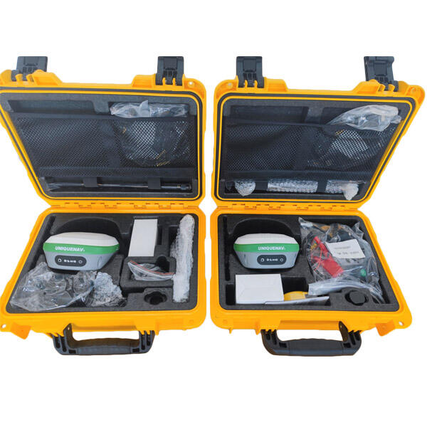
An RTK base station GNSS represents a revolutionary positioning technology that delivers centimeter-level accuracy for surveying, mapping, and navigation applications. The RTK base station GNSS operates by establishing a fixed reference point with known coordinates, continuously receiving satellite signals from multiple constellations including GPS, GLONASS, Galileo, and BeiDou. This sophisticated system calculates positioning corrections in real-time and transmits them to mobile rovers within its coverage area, typically extending up to 10-20 kilometers depending on environmental conditions and equipment specifications. The fundamental principle behind RTK base station GNSS technology involves differential correction, where the base station compares its calculated position with its known precise coordinates to determine atmospheric delays, satellite orbit errors, and other systematic biases affecting satellite signals. These corrections are then broadcast to rover units, enabling them to achieve remarkable positioning accuracy of 1-2 centimeters horizontally and 2-3 centimeters vertically. Modern RTK base station GNSS systems incorporate advanced features such as multi-constellation tracking, which simultaneously processes signals from various satellite systems to enhance reliability and reduce initialization time. The stations utilize sophisticated algorithms for ambiguity resolution, ensuring rapid convergence and maintaining consistent accuracy even in challenging environments. Communication capabilities include radio modems, cellular networks, and internet protocols, providing flexible data transmission options to suit different project requirements. The rugged construction of RTK base station GNSS equipment ensures reliable operation in harsh weather conditions, featuring weatherproof enclosures, extended temperature ranges, and long-lasting batteries for continuous field operations. These systems serve as the backbone for precision agriculture, construction surveying, mining operations, geographic information systems, and autonomous vehicle navigation, making them indispensable tools for professionals requiring high-accuracy positioning data.

New Products

The RTK base station GNSS delivers exceptional positioning accuracy that transforms how professionals approach surveying and mapping tasks. Users achieve centimeter-level precision consistently, eliminating the need for traditional surveying methods that consume significant time and resources. This remarkable accuracy reduces measurement errors, prevents costly mistakes, and ensures project specifications meet the highest standards. The system operates efficiently across large areas, allowing a single RTK base station GNSS to serve multiple rover units simultaneously within its coverage zone. This capability dramatically increases productivity as survey teams can work independently while maintaining unified accuracy standards throughout the project site. The real-time nature of RTK base station GNSS corrections means users receive instant feedback on their positioning, enabling immediate decision-making and reducing field revisits. Cost-effectiveness represents another significant advantage, as the RTK base station GNSS eliminates expenses associated with traditional surveying equipment, reduces labor requirements, and minimizes project completion time. Organizations investing in this technology typically recover their investment within months through increased efficiency and reduced operational costs. The versatility of RTK base station GNSS applications spans numerous industries, making it valuable for construction companies, agricultural enterprises, mining operations, and environmental consultancies. Users benefit from simplified workflows as the system automates many complex calculations previously requiring manual computation and verification. Weather resistance ensures continuous operation regardless of environmental conditions, providing reliable service during critical project phases when delays prove expensive. The scalability of RTK base station GNSS networks allows organizations to expand coverage areas by adding additional base stations, creating comprehensive positioning infrastructure for large-scale operations. Integration capabilities with existing software and hardware systems streamline adoption processes, enabling users to incorporate RTK base station GNSS technology into established workflows without major disruptions. The system requires minimal maintenance compared to traditional surveying equipment, reducing ongoing operational costs and ensuring consistent availability for field operations. Training requirements remain manageable, allowing teams to become proficient quickly and maximize return on technology investment through immediate productivity gains.

Latest News

How Can RTK Improve Surveying Precision for Large Construction Sites?

22

Dec

How Can RTK Improve Surveying Precision for Large Construction Sites?

Modern construction projects demand unprecedented accuracy and efficiency, particularly when dealing with expansive development sites spanning hundreds of acres. Traditional surveying methods often fall short when faced with the complexities of large...
View More
What Should Engineers Check Before Choosing an RTK System?

22

Dec

What Should Engineers Check Before Choosing an RTK System?

Selecting the right RTK system represents one of the most critical decisions in modern surveying and construction projects. Engineers must navigate through numerous technical specifications, accuracy requirements, and operational considerations to en...
View More
Why Is RTK GNSS Essential for High-Accuracy Industrial Positioning?

22

Dec

Why Is RTK GNSS Essential for High-Accuracy Industrial Positioning?

In today's rapidly evolving industrial landscape, precise positioning has become the cornerstone of operational excellence across multiple sectors. RTK GNSS technology represents a quantum leap forward in positioning accuracy, delivering centimeter-l...
View More
Why Are Digital Levels Preferred Over Traditional Bubble Levels?

11

Feb

Why Are Digital Levels Preferred Over Traditional Bubble Levels?

The construction and engineering industries have witnessed a significant transformation in measurement tools over the past decade. Among these advancements, digital levels have emerged as the preferred choice for professionals who demand precision, e...
View More

Get a Free Quote

Our representative will contact you soon.
Email
Name
Company Name
Message
0/1000

rtk base station gnss

Unmatched Precision and Reliability for Professional Applications

Unmatched Precision and Reliability for Professional Applications

The RTK base station GNSS delivers extraordinary positioning accuracy that surpasses traditional surveying methods by significant margins, providing users with centimeter-level precision that transforms project outcomes and professional standards. This exceptional accuracy stems from advanced differential correction algorithms that continuously monitor and compensate for atmospheric disturbances, satellite orbit variations, and other factors affecting positioning quality. The system processes signals from multiple satellite constellations simultaneously, including GPS, GLONASS, Galileo, and BeiDou, creating a robust positioning solution that maintains accuracy even when individual satellites become temporarily unavailable. Users experience remarkable consistency in measurement quality, with horizontal accuracy typically achieving 1-2 centimeters and vertical accuracy reaching 2-3 centimeters under normal operating conditions. This precision level enables professionals to confidently execute complex projects requiring strict tolerance specifications, such as infrastructure construction, precision agriculture applications, and detailed topographic mapping. The reliability aspect proves equally important, as the RTK base station GNSS maintains consistent performance across varying environmental conditions and geographical locations. Weather resistance features protect internal components from moisture, dust, and temperature extremes, ensuring continuous operation during challenging field conditions when project schedules cannot accommodate delays. The system incorporates redundancy features that prevent data loss and maintain positioning continuity even during temporary communication interruptions or satellite signal degradation. Quality assurance mechanisms continuously monitor system performance, alerting users to potential issues before they affect measurement accuracy. This proactive approach to reliability management gives professionals confidence in their data quality and enables them to make critical decisions based on trusted positioning information. The combination of precision and reliability creates significant value for organizations requiring dependable positioning solutions, reducing risks associated with measurement errors and ensuring project completion within specified parameters and timelines.
Enhanced Productivity Through Real-Time Operations and Multi-User Support

Enhanced Productivity Through Real-Time Operations and Multi-User Support

The RTK base station GNSS revolutionizes workplace efficiency by providing real-time positioning corrections that eliminate traditional surveying bottlenecks and enable simultaneous multi-user operations across extensive project areas. This capability transforms how teams approach large-scale projects by allowing multiple rover units to operate independently while maintaining unified accuracy standards throughout the work site. The real-time aspect means users receive positioning corrections instantaneously, enabling immediate data collection and analysis without delays associated with post-processing workflows. Survey teams can make on-site decisions with confidence, identify and resolve issues immediately, and maintain project momentum without interrupting field operations for data verification. The multi-user functionality proves particularly valuable for complex projects involving multiple disciplines or phases, as different teams can work simultaneously without interfering with each other's operations or compromising data quality. This parallel processing capability often reduces project completion times by 50-70 percent compared to traditional sequential surveying approaches. Communication flexibility enhances productivity further, as the RTK base station GNSS supports various data transmission methods including radio frequencies, cellular networks, and internet protocols, ensuring reliable connections regardless of project location or infrastructure availability. The system automatically manages correction data distribution, eliminating manual coordination requirements and reducing opportunities for human error in data handling. Integration capabilities with popular surveying software and CAD applications streamline data workflows, allowing users to import positioning data directly into design and analysis programs without format conversion or manual data entry. This seamless integration eliminates transcription errors and accelerates project deliverables preparation. The extended operating range of modern RTK base station GNSS equipment covers areas up to 20 kilometers radius, providing comprehensive coverage for large construction sites, agricultural fields, or mining operations from a single installation point, maximizing equipment utilization and minimizing setup requirements.
Cost-Effective Solution with Scalable Infrastructure Capabilities

Cost-Effective Solution with Scalable Infrastructure Capabilities

The RTK base station GNSS represents exceptional value through its cost-effective operation model and scalable infrastructure design that grows with organizational needs and project requirements. Initial investment costs prove reasonable when compared to traditional surveying equipment portfolios, and operational savings accumulate rapidly through reduced labor requirements, eliminated equipment rental fees, and decreased project completion times. Organizations typically achieve complete cost recovery within 6-12 months of implementation, with ongoing savings continuing throughout the equipment lifespan. The system eliminates expenses associated with traditional surveying methods including theodolites, total stations, and level instruments, while simultaneously reducing the skilled labor requirements for basic positioning tasks. Maintenance costs remain minimal due to solid-state electronics and robust construction that withstand harsh field conditions without frequent repairs or calibration requirements. The scalable nature of RTK base station GNSS infrastructure allows organizations to start with single-station installations and expand coverage areas by adding networked base stations as business needs grow or project complexity increases. This modular approach prevents over-investment in initial phases while ensuring future expansion capability without system replacement. Network configurations enable resource sharing across multiple project sites, maximizing equipment utilization and return on investment. The versatility of RTK base station GNSS applications across multiple industries provides additional value, as the same equipment serves construction, agriculture, mining, and mapping applications without modification or additional purchases. Training costs remain reasonable due to intuitive operation interfaces and comprehensive support resources, enabling teams to achieve proficiency quickly and begin generating returns immediately. Reduced project risk through improved accuracy translates to fewer costly corrections, rework situations, and potential liability issues, providing additional financial benefits beyond direct operational savings. The extended equipment lifespan typical of professional RTK base station GNSS systems ensures long-term value retention, while technology upgrade paths protect investment value as positioning standards and requirements evolve over time.

Get a Free Quote

Our representative will contact you soon.
Email
Name
Company Name
Message
0/1000