Professional GNSS GPS Survey Equipment - High-Precision Positioning Solutions for Surveying

All Categories

gnss gps survey equipment

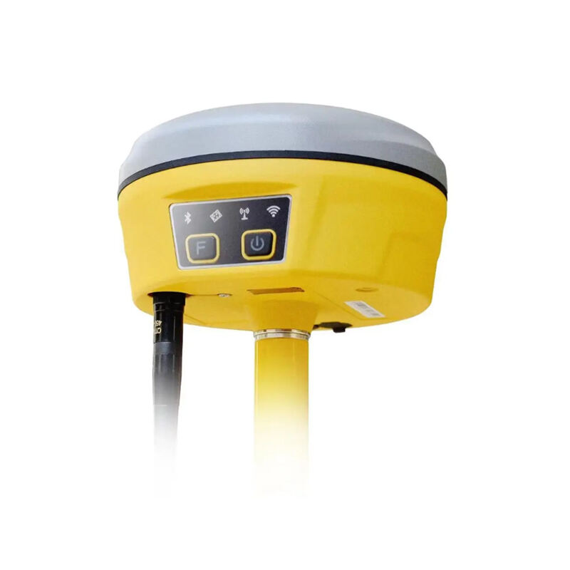
GNSS GPS survey equipment represents cutting-edge positioning technology that revolutionizes land surveying, construction, and mapping operations worldwide. This sophisticated instrumentation combines Global Navigation Satellite System capabilities with advanced GPS functionality to deliver precise coordinate measurements and spatial data collection. Modern GNSS GPS survey equipment integrates multiple satellite constellations including GPS, GLONASS, Galileo, and BeiDou systems to ensure optimal signal reception and enhanced accuracy under various environmental conditions. The equipment typically consists of a high-precision receiver unit, antenna assembly, data controller, and specialized software applications designed for professional surveying applications. These systems utilize Real-Time Kinematic positioning technology to achieve centimeter-level accuracy in both horizontal and vertical measurements. The robust construction of GNSS GPS survey equipment ensures reliable performance in challenging field conditions, featuring weather-resistant housings and extended battery life for continuous operation. Advanced signal processing algorithms automatically compensate for atmospheric interference, multipath errors, and satellite geometry variations to maintain consistent measurement quality. The equipment supports various survey methodologies including static observations, rapid static sessions, and kinematic surveys to accommodate diverse project requirements. Professional-grade GNSS GPS survey equipment incorporates built-in quality control features that monitor measurement precision and alert operators to potential accuracy degradation. The systems offer seamless integration with existing survey workflows through standardized data formats and compatibility with popular Computer-Aided Design software platforms. Modern units feature intuitive touchscreen interfaces that simplify field operations and reduce training requirements for survey personnel. The equipment supports network RTK corrections through cellular or radio communication links to enhance positioning accuracy across extended work areas. These versatile systems serve multiple industries including civil engineering, agriculture, mining, utilities, and environmental monitoring applications where precise spatial positioning is essential for project success.

New Product Recommendations

GNSS GPS survey equipment delivers exceptional measurement precision that surpasses traditional surveying methods by achieving centimeter-level accuracy consistently across large project areas. This superior accuracy eliminates costly resurvey requirements and reduces project delays caused by measurement errors. The equipment operates independently of line-of-sight requirements between survey points, enabling surveyors to establish control networks efficiently across challenging terrain and obstructed environments. Users benefit from dramatically reduced field time compared to conventional theodolite and EDM measurements, as GNSS GPS survey equipment captures coordinate data instantaneously without requiring multiple instrument setups or traverse calculations. The technology enables single-person survey operations, reducing labor costs and improving project economics while maintaining professional-grade accuracy standards. Real-time data processing capabilities allow immediate quality assessment and field verification, preventing costly data collection errors that might otherwise require expensive return trips to project sites. The equipment integrates seamlessly with digital mapping software and Geographic Information Systems, streamlining data transfer and eliminating manual coordinate transcription errors. Modern GNSS GPS survey equipment supports multiple coordinate systems and datum transformations, providing flexibility for projects spanning different jurisdictions or requiring various projection formats. The systems offer exceptional versatility by supporting diverse survey applications from boundary establishment to construction layout and topographic mapping within a single instrument platform. Users appreciate the equipment's ability to work effectively in various weather conditions and lighting situations, unlike optical instruments that may be limited by fog, rain, or low-light conditions. The technology provides consistent results regardless of operator skill level variations, as satellite positioning eliminates subjective measurements and human error sources common in traditional surveying techniques. Equipment portability allows easy transportation between survey locations, with lightweight designs that reduce physical strain on field personnel during extended survey sessions. The systems offer excellent return on investment through increased productivity, reduced project timelines, and enhanced measurement reliability that minimizes professional liability exposure. Advanced error detection and correction algorithms automatically identify and compensate for common measurement problems, ensuring data quality without requiring extensive operator intervention or specialized technical knowledge.

Tips And Tricks

GNSS RTK vs. Traditional Surveying: What’s the Difference?

27

Nov

GNSS RTK vs. Traditional Surveying: What’s the Difference?

Modern surveying has undergone a revolutionary transformation with the introduction of Global Navigation Satellite Systems (GNSS) technology, particularly Real-Time Kinematic (RTK) positioning. While traditional surveying methods have served the cons...
View More
Why Is RTK GNSS Essential for High-Accuracy Industrial Positioning?

22

Dec

Why Is RTK GNSS Essential for High-Accuracy Industrial Positioning?

In today's rapidly evolving industrial landscape, precise positioning has become the cornerstone of operational excellence across multiple sectors. RTK GNSS technology represents a quantum leap forward in positioning accuracy, delivering centimeter-l...
View More
How Do RTK GNSS Receivers Maintain Stability in Complex Terrains?

22

Dec

How Do RTK GNSS Receivers Maintain Stability in Complex Terrains?

Navigation accuracy in challenging environments has become a critical requirement across industries ranging from construction and surveying to autonomous vehicles and precision agriculture. RTK GNSS receivers represent the pinnacle of satellite-based...
View More
How Does RTK GPS Reduce Errors in Professional Survey Work?

13

Jan

How Does RTK GPS Reduce Errors in Professional Survey Work?

Professional surveying demands precision that can make the difference between project success and costly mistakes. Traditional GPS systems, while revolutionary, often fall short of the accuracy requirements needed for construction, engineering, and l...
View More

Get a Free Quote

Our representative will contact you soon.
Email
Name
Company Name
Message
0/1000

gnss gps survey equipment

Unmatched Precision and Multi-Constellation Support

Unmatched Precision and Multi-Constellation Support

The advanced GNSS GPS survey equipment harnesses the power of multiple satellite constellations simultaneously to deliver unparalleled positioning accuracy and reliability for professional surveying applications. By accessing GPS, GLONASS, Galileo, and BeiDou satellite networks concurrently, this technology ensures optimal satellite geometry and signal availability even in challenging environments such as urban canyons, dense forests, or mountainous terrain where traditional single-constellation systems might struggle. The multi-constellation approach significantly reduces the time required to achieve initial position fixes and maintains tracking continuity when individual satellites become temporarily obscured. This comprehensive satellite coverage translates directly into enhanced productivity for survey professionals who can confidently work in previously problematic locations without compromising measurement quality. The equipment employs sophisticated signal processing algorithms that intelligently select the best available satellite signals while automatically rejecting degraded or unreliable transmissions that could compromise accuracy. Real-Time Kinematic processing capabilities enable the system to achieve centimeter-level precision in both horizontal and vertical dimensions, meeting the stringent accuracy requirements of professional land surveying, construction layout, and engineering applications. The technology continuously monitors measurement quality through statistical analysis of satellite observations, providing real-time confidence indicators that help operators make informed decisions about data collection procedures. Advanced atmospheric modeling compensates for ionospheric and tropospheric delays that can affect satellite signal propagation, ensuring consistent accuracy across varying environmental conditions and geographic locations. The system's ability to maintain lock on satellite signals during brief interruptions prevents data gaps that could compromise survey efficiency, while automatic re-initialization procedures quickly restore full functionality when signal blockages are cleared. This robust multi-constellation support effectively future-proofs survey investments by ensuring compatibility with emerging satellite systems and evolving GNSS technologies, providing long-term value and operational reliability for surveying professionals who depend on precise positioning data for critical project decisions.
Streamlined Workflow Integration and Data Management

Streamlined Workflow Integration and Data Management

Modern GNSS GPS survey equipment revolutionizes traditional surveying workflows through seamless integration capabilities that connect field data collection directly with office-based design and analysis software systems. This comprehensive integration eliminates time-consuming manual data transfer processes while reducing transcription errors that can compromise project accuracy and efficiency. The equipment supports industry-standard data formats including RINEX, RAW, and proprietary formats that ensure compatibility with popular Computer-Aided Design platforms such as AutoCAD, Civil 3D, and specialized surveying software packages. Built-in data management features automatically organize survey observations by project, date, and operator while maintaining complete audit trails that document measurement procedures and quality parameters for professional record-keeping requirements. Real-time data validation algorithms continuously assess measurement quality and alert operators to potential problems before they affect project outcomes, enabling immediate corrective actions that prevent costly resurvey requirements. The system's wireless communication capabilities support automatic data synchronization with cloud-based project management platforms, allowing multiple team members to access current survey information regardless of their physical location. Advanced coordinate transformation tools handle complex datum conversions and projection calculations automatically, ensuring that survey data integrates properly with existing project control networks and mapping systems. The equipment features intuitive touchscreen interfaces that guide operators through complex survey procedures while providing contextual help and error prevention features that minimize training requirements and reduce operational mistakes. Customizable data collection forms streamline field observations by prompting operators for required attribute information while maintaining consistency across different survey projects and personnel. The system maintains comprehensive metadata for each measurement point, including accuracy estimates, satellite constellation information, and environmental conditions that support quality assurance procedures and professional liability documentation. Automated backup procedures protect valuable survey data against loss while ensuring that multiple copies are available for project continuity and disaster recovery purposes. These integrated workflow capabilities transform GNSS GPS survey equipment from simple measurement tools into comprehensive project management platforms that enhance productivity, improve accuracy, and reduce operational costs across diverse surveying applications and project scales.
Exceptional Durability and Field Performance

Exceptional Durability and Field Performance

Professional-grade GNSS GPS survey equipment demonstrates exceptional durability and reliability through rugged construction designed to withstand demanding field conditions encountered in diverse surveying environments. The equipment features military-specification environmental sealing that protects sensitive electronic components from dust, moisture, and temperature extremes while maintaining operational integrity in harsh climates and challenging work sites. Advanced shock-absorbing designs protect critical components from impact damage during transportation and field handling, ensuring consistent performance despite the physical demands of professional survey operations. The systems incorporate high-capacity lithium-ion battery technology that provides extended operational periods exceeding eight hours of continuous use, eliminating productivity interruptions caused by frequent battery changes and enabling completion of extensive survey sessions without equipment downtime. Intelligent power management algorithms optimize energy consumption while maintaining full measurement accuracy, extending battery life and reducing the need for frequent recharging cycles that can impact field productivity. The equipment features corrosion-resistant materials and protective coatings that prevent degradation from exposure to saltwater, chemicals, and industrial pollutants commonly encountered in surveying applications near coastlines, construction sites, and industrial facilities. Enhanced thermal management systems maintain optimal operating temperatures across extreme weather conditions, ensuring reliable performance from arctic environments to tropical climates without accuracy degradation or system failures. The robust antenna designs resist physical damage while maintaining precise phase center stability essential for high-accuracy measurements, incorporating lightning protection circuits that safeguard equipment during electrical storms. Field-replaceable components minimize downtime and repair costs by allowing quick replacement of wear items such as batteries, cables, and protective accessories without requiring factory service or extensive technical expertise. The equipment undergoes rigorous quality testing including vibration, temperature cycling, and humidity exposure assessments that verify performance specifications under extreme conditions before reaching professional users. Comprehensive warranty coverage and global service support networks ensure rapid resolution of technical issues while minimizing project interruptions caused by equipment problems. These durability features provide exceptional value through reduced replacement costs, minimized maintenance requirements, and consistent operational reliability that surveying professionals depend upon for critical project completion and client satisfaction.

Get a Free Quote

Our representative will contact you soon.
Email
Name
Company Name
Message
0/1000