Professional RTK Survey Solutions: Real-Time Precision Positioning Technology

All Categories

rtk survey

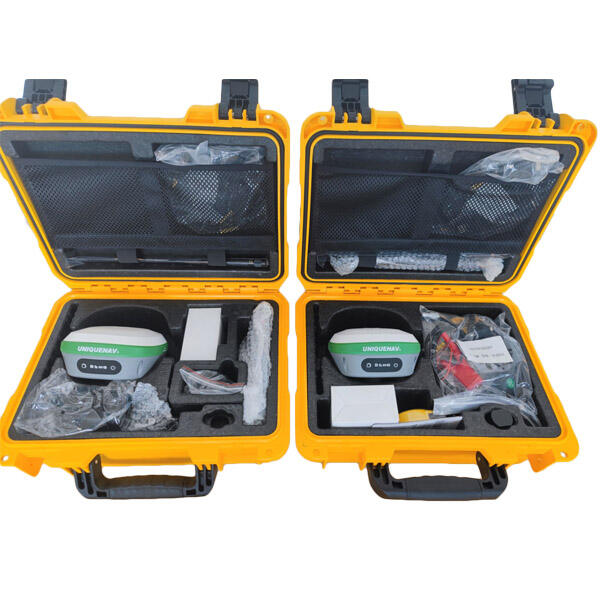
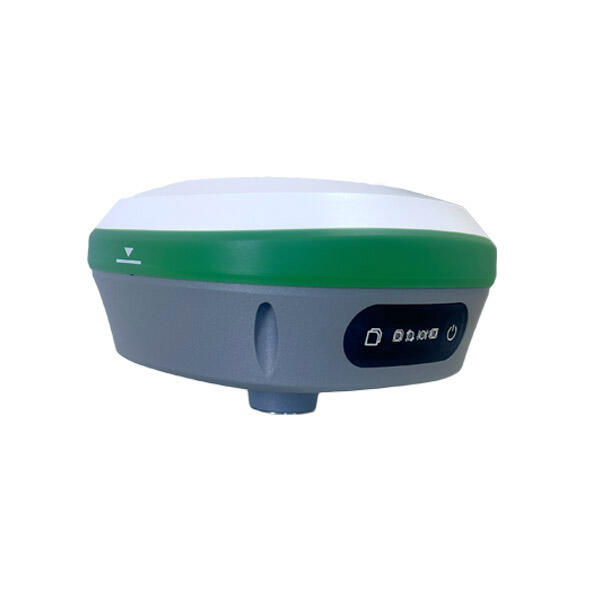
Real-Time Kinematic (RTK) survey technology represents a revolutionary advancement in Global Navigation Satellite System (GNSS) positioning, delivering centimeter-level accuracy for professional surveying applications. This sophisticated positioning method utilizes a network of base stations and mobile receivers to provide instantaneous corrections to satellite signals, enabling surveyors to achieve unprecedented precision in their measurements. The RTK survey system operates by establishing a reference station at a known coordinate location, which continuously monitors satellite signals and calculates correction data. This information is transmitted in real-time to rover units operating within the coverage area, allowing field personnel to obtain highly accurate positioning data without the traditional delays associated with post-processing methods. The technological foundation of RTK survey systems relies on advanced algorithms that analyze carrier phase measurements from multiple satellite constellations, including GPS, GLONASS, Galileo, and BeiDou networks. These systems can track dozens of satellites simultaneously, ensuring robust signal reception even in challenging environments with partial sky obstruction. The RTK survey methodology incorporates sophisticated error modeling techniques that compensate for atmospheric delays, satellite orbit uncertainties, and other systematic errors that can affect positioning accuracy. Modern RTK survey equipment features integrated communication capabilities, supporting various data transmission methods including radio modems, cellular networks, and internet protocols. This connectivity enables seamless coordination between multiple survey teams and central office operations, facilitating efficient project management and quality control procedures. The versatility of RTK survey technology extends across numerous industries, from construction and engineering to agriculture and environmental monitoring. Applications include topographic mapping, construction layout, infrastructure development, property boundary determination, and precision agriculture operations. The technology's ability to provide immediate results significantly reduces field time requirements while maintaining the highest standards of accuracy demanded by professional surveying practices.

New Product Recommendations

RTK survey technology delivers exceptional speed and efficiency compared to traditional surveying methods, enabling field crews to complete projects in significantly less time while maintaining superior accuracy standards. Unlike conventional total station surveys that require line-of-sight measurements between instrument positions, RTK survey systems provide direct coordinate positioning from satellite signals, eliminating the need for complex traverse networks and reducing setup procedures. This streamlined workflow allows surveyors to collect data points rapidly across large areas without establishing multiple control points or conducting time-intensive calculations. The real-time nature of RTK survey corrections means that field personnel receive immediate feedback on measurement quality, enabling instant verification and reducing the likelihood of errors that might require costly return visits to project sites. Cost-effectiveness represents another significant advantage of RTK survey implementation, as organizations can reduce labor expenses through improved productivity and decreased field time requirements. The technology eliminates many traditional surveying procedures, such as establishing temporary benchmarks and conducting extensive traverse calculations, resulting in substantial time savings that translate directly to project cost reductions. Additionally, the enhanced accuracy of RTK survey measurements reduces the risk of construction errors and rework, providing long-term financial benefits that extend well beyond initial equipment investments. RTK survey systems offer remarkable versatility in challenging terrain conditions where conventional surveying methods may prove difficult or impossible to implement. The satellite-based positioning capability allows surveyors to work effectively in areas with limited visibility, dense vegetation, or irregular topography that would typically require extensive clearing or alternative measurement techniques. This flexibility enables project completion in previously inaccessible locations while maintaining consistent accuracy standards regardless of environmental conditions. The technology's multi-constellation satellite tracking capability ensures reliable performance even in urban environments with tall buildings or forested areas with partial sky obstruction. Integration capabilities with modern digital workflows represent a crucial advantage of RTK survey systems, as data collected in the field seamlessly transfers to computer-aided design software, geographic information systems, and construction management platforms. This digital integration eliminates manual data entry procedures and reduces transcription errors while enabling immediate analysis and visualization of survey results. The compatibility with cloud-based data sharing platforms facilitates real-time collaboration between field crews, office personnel, and project stakeholders, improving communication and decision-making processes throughout project lifecycles.

Tips And Tricks

How GNSS RTK Systems Deliver High-Precision Results

27

Nov

How GNSS RTK Systems Deliver High-Precision Results

Modern surveying and positioning applications demand exceptional accuracy that traditional GPS systems simply cannot deliver. Global Navigation Satellite System Real-Time Kinematic (GNSS RTK Systems) have revolutionized precision positioning by provi...
View More
Why Is RTK GNSS Essential for High-Accuracy Industrial Positioning?

22

Dec

Why Is RTK GNSS Essential for High-Accuracy Industrial Positioning?

In today's rapidly evolving industrial landscape, precise positioning has become the cornerstone of operational excellence across multiple sectors. RTK GNSS technology represents a quantum leap forward in positioning accuracy, delivering centimeter-l...
View More
How Does an Auto Level Improve Site-Leveling Efficiency?

11

Feb

How Does an Auto Level Improve Site-Leveling Efficiency?

Construction and surveying professionals consistently seek tools that enhance precision while reducing time-consuming manual processes. The auto level stands as one of the most crucial instruments in modern site-leveling operations, transforming how ...
View More
What Key Features Should You Check When Buying an Auto Level?

11

Feb

What Key Features Should You Check When Buying an Auto Level?

When precision matters most in construction and surveying projects, selecting the right auto level becomes a critical decision that can impact the success of your entire operation. An auto level serves as the backbone of accurate height measurements ...
View More

Get a Free Quote

Our representative will contact you soon.
Email
Name
Company Name
Message
0/1000

rtk survey

Centimeter-Level Precision in Real-Time Operations

Centimeter-Level Precision in Real-Time Operations

The exceptional accuracy capabilities of RTK survey systems deliver centimeter-level precision consistently across diverse project environments, setting new standards for professional surveying applications. This remarkable precision stems from advanced carrier phase measurement techniques that analyze satellite signals at the millimeter level, combined with sophisticated algorithms that process correction data instantaneously. Unlike traditional positioning methods that may achieve meter-level accuracy, RTK survey technology routinely delivers horizontal accuracies within 1-2 centimeters and vertical accuracies within 2-3 centimeters under optimal conditions. This precision level enables surveyors to meet the most stringent accuracy requirements for critical infrastructure projects, including bridge construction, tunnel alignment, and high-rise building foundations where minimal tolerances are essential for structural integrity. The real-time aspect of this precision represents a fundamental breakthrough in surveying efficiency, as field personnel can immediately verify measurement quality and make necessary adjustments without returning to office environments for post-processing procedures. This immediate feedback capability significantly reduces project timelines while ensuring that accuracy standards are maintained throughout data collection activities. The consistency of RTK survey precision across extended working periods provides substantial advantages for large-scale projects requiring numerous measurement sessions, as surveyors can maintain uniform accuracy standards regardless of temporal variations in atmospheric conditions or satellite geometry. Advanced quality control features integrated within RTK survey systems continuously monitor measurement precision indicators, alerting operators to potential accuracy degradation and ensuring that collected data meets specified tolerance requirements. This automated quality assurance capability reduces the risk of accepting substandard measurements and provides confidence in the reliability of survey results for critical decision-making processes.
Comprehensive Multi-Constellation Satellite Support

Comprehensive Multi-Constellation Satellite Support

Modern RTK survey systems leverage comprehensive multi-constellation satellite support, accessing signals from GPS, GLONASS, Galileo, BeiDou, and other emerging navigation systems to deliver unprecedented reliability and performance consistency. This extensive satellite coverage ensures robust positioning capabilities even in challenging environments where traditional single-constellation systems might experience signal limitations or degraded accuracy. The utilization of multiple satellite constellations provides significant advantages in urban environments characterized by tall buildings, dense infrastructure, or complex skyline geometries that can obstruct satellite visibility. By tracking signals from 60 or more satellites simultaneously, RTK survey systems maintain positioning capability when individual satellites become temporarily unavailable due to physical obstructions or atmospheric interference. This multi-constellation approach enhances geometric diversity in satellite positioning calculations, resulting in improved accuracy and reduced position dilution of precision values that directly correlate to measurement quality. The redundancy provided by multiple satellite systems ensures operational continuity during satellite maintenance periods or unexpected system outages that might affect individual constellation performance. Advanced RTK survey receivers incorporate intelligent satellite selection algorithms that automatically optimize constellation usage based on current sky visibility conditions, signal strength measurements, and geometric considerations. This automated optimization ensures that the system consistently utilizes the best available satellite combinations for maximum positioning accuracy while maintaining computational efficiency. The global coverage provided by multiple satellite constellations enables RTK survey operations across diverse geographical regions without performance degradation, supporting international projects and organizations operating in multiple countries. Future-proofing capabilities inherent in multi-constellation support ensure that RTK survey investments remain viable as new satellite systems become operational and existing constellations undergo modernization programs.
Seamless Digital Integration and Workflow Optimization

Seamless Digital Integration and Workflow Optimization

RTK survey technology excels in seamless digital integration capabilities that transform traditional surveying workflows through automated data management, cloud connectivity, and comprehensive software compatibility. Modern RTK survey systems feature sophisticated data management platforms that automatically organize, validate, and distribute measurement results across project teams while maintaining complete audit trails for quality assurance purposes. This digital integration eliminates manual data transcription procedures that historically introduced errors and consumed valuable time resources, replacing them with automated processes that ensure data integrity throughout project lifecycles. The cloud connectivity features enable real-time data sharing between field crews, office personnel, and project stakeholders, facilitating immediate collaboration and decision-making processes that accelerate project completion timelines. Advanced RTK survey platforms support direct integration with leading computer-aided design software, geographic information systems, and Building Information Modeling applications, enabling surveyors to deliver measurement results in formats specifically tailored to client requirements. This compatibility reduces post-processing overhead while ensuring that survey data integrates smoothly with existing project workflows and software environments. The automated quality control features embedded within digital RTK survey platforms continuously monitor measurement parameters and flag potential issues before they impact project outcomes, providing proactive error prevention capabilities that enhance overall data reliability. Mobile device compatibility enables field personnel to access comprehensive project information, reference materials, and communication tools through tablet computers and smartphones, creating fully integrated digital work environments that support efficient field operations. The scalability of digital RTK survey platforms accommodates projects ranging from small-scale boundary surveys to large infrastructure developments, providing consistent functionality and performance characteristics regardless of project complexity or duration. Advanced reporting capabilities generate comprehensive documentation automatically, including measurement summaries, accuracy assessments, and compliance certifications that satisfy regulatory requirements and client specifications without additional manual preparation efforts.

Get a Free Quote

Our representative will contact you soon.
Email
Name
Company Name
Message
0/1000