Simple RTK Technology: Precision Positioning Made Easy for Professional Surveying and Navigation

All Categories

simple rtk

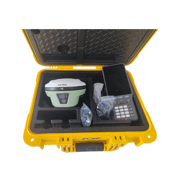
Simple RTK represents a revolutionary approach to real-time kinematic positioning that transforms complex surveying and navigation tasks into accessible, user-friendly operations. This cutting-edge technology delivers centimeter-level accuracy positioning by utilizing GPS, GLONASS, Galileo, and BeiDou satellite systems in conjunction with correction data streams. The simple RTK system eliminates traditional barriers that once made precision positioning exclusively available to specialized professionals, democratizing high-accuracy location services for diverse industries and applications. At its core, simple RTK operates by establishing a base station that broadcasts correction signals to rover units, enabling them to achieve positioning accuracy within 1-2 centimeters horizontally and 2-3 centimeters vertically. The system supports multiple communication methods including radio, cellular networks, and internet connections, ensuring reliable data transmission across various operational environments. Modern simple RTK solutions feature intuitive interfaces that require minimal technical expertise, allowing operators to begin collecting precise measurements within minutes of setup. The technology incorporates advanced algorithms that automatically handle complex calculations, satellite signal processing, and atmospheric corrections that traditionally required extensive technical knowledge. Key applications span construction site surveying, precision agriculture, land mapping, infrastructure monitoring, and autonomous vehicle navigation. The simple RTK system supports both static and kinematic positioning modes, accommodating diverse workflow requirements from boundary surveys to dynamic machine control applications. Integration capabilities extend to popular GIS software, CAD programs, and specialized surveying applications, streamlining data collection and processing workflows. The technology features robust error detection and correction mechanisms that maintain accuracy even in challenging environments with satellite signal interference or multipath effects.

New Product Releases

Simple RTK technology delivers exceptional value by dramatically reducing operational costs compared to traditional surveying methods. Organizations can eliminate expensive equipment rentals and reduce dependence on specialized surveying contractors, achieving significant long-term savings while maintaining professional-grade accuracy standards. The system enables rapid deployment and immediate productivity, with most operators becoming proficient within hours rather than weeks of training typically required for conventional RTK systems. This accessibility advantage transforms positioning workflows by allowing non-technical personnel to collect precise measurements, expanding operational capacity without additional specialized hiring. The simple RTK approach provides consistent accuracy across diverse environmental conditions, maintaining centimeter-level precision whether operating in urban areas with building interference, forested regions with canopy obstruction, or open agricultural fields. This reliability eliminates the uncertainty and rework costs associated with less accurate positioning methods, ensuring project timelines and budgets remain predictable. Real-time data collection capabilities enable immediate decision-making and quality control, preventing costly errors that might otherwise go undetected until later project phases. The technology supports seamless integration with existing workflows and software systems, minimizing disruption while maximizing productivity gains. Simple RTK systems offer exceptional portability and battery life, enabling full-day operations without frequent recharging or cumbersome power supply arrangements. The technology scales efficiently from single-operator applications to complex multi-user networks, accommodating growing operational requirements without significant infrastructure investments. Advanced connectivity options ensure reliable performance across various geographic locations and network conditions, maintaining productivity regardless of cellular coverage limitations. The simple RTK solution provides comprehensive data logging and export capabilities, facilitating regulatory compliance, project documentation, and quality assurance requirements. Remote monitoring and support features enable proactive maintenance scheduling and rapid troubleshooting, minimizing downtime and ensuring consistent performance. The technology delivers future-proof investment value through regular software updates and expanding satellite constellation support, protecting equipment investments while continuously improving capabilities.

Practical Tips

How Can RTK Improve Surveying Precision for Large Construction Sites?

22

Dec

How Can RTK Improve Surveying Precision for Large Construction Sites?

Modern construction projects demand unprecedented accuracy and efficiency, particularly when dealing with expansive development sites spanning hundreds of acres. Traditional surveying methods often fall short when faced with the complexities of large...
View More
What Should Engineers Check Before Choosing an RTK System?

22

Dec

What Should Engineers Check Before Choosing an RTK System?

Selecting the right RTK system represents one of the most critical decisions in modern surveying and construction projects. Engineers must navigate through numerous technical specifications, accuracy requirements, and operational considerations to en...
View More
How Do RTK GNSS Receivers Maintain Stability in Complex Terrains?

22

Dec

How Do RTK GNSS Receivers Maintain Stability in Complex Terrains?

Navigation accuracy in challenging environments has become a critical requirement across industries ranging from construction and surveying to autonomous vehicles and precision agriculture. RTK GNSS receivers represent the pinnacle of satellite-based...
View More
What Should You Evaluate Before Purchasing a Total Station?

13

Jan

What Should You Evaluate Before Purchasing a Total Station?

When investing in surveying equipment, selecting the right total station represents one of the most critical decisions for engineering professionals, construction teams, and surveying companies. A total station serves as the backbone of precise measu...
View More

Get a Free Quote

Our representative will contact you soon.
Email
Name
Company Name
Message
0/1000

simple rtk

Instant Setup and User-Friendly Operation

Instant Setup and User-Friendly Operation

Simple RTK technology revolutionizes positioning workflows through its remarkable ease of use and rapid deployment capabilities that eliminate traditional barriers to precision surveying. Unlike conventional RTK systems that require extensive technical training and complex configuration procedures, simple RTK solutions feature intuitive interfaces and automated setup processes that enable operators to achieve centimeter-level accuracy within minutes of unpacking the equipment. The system automatically detects and connects to available satellite constellations, configures optimal correction parameters, and establishes communication links without requiring manual intervention or technical expertise. This streamlined approach transforms the user experience by providing guided setup wizards, visual status indicators, and clear operational feedback that keeps operators informed throughout the positioning process. The simple RTK interface eliminates confusing technical terminology and complex menu structures, presenting essential information in straightforward displays that anyone can understand and act upon. Automated quality control features continuously monitor positioning accuracy and alert operators to potential issues before they impact measurement quality, ensuring consistent results regardless of operator experience level. The technology incorporates smart algorithms that adapt to changing environmental conditions, automatically adjusting parameters to maintain optimal performance without requiring operator intervention. Battery management systems provide accurate runtime estimates and low-power warnings, preventing unexpected shutdowns during critical operations. The simple RTK solution supports multiple measurement modes and data formats, accommodating diverse project requirements while maintaining consistent operational simplicity. Quick-start guides and interactive tutorials embedded within the system enable rapid skill development and confidence building for new operators. The technology features robust construction and weather-resistant designs that withstand challenging field conditions while maintaining reliable performance and ease of use.
Multi-Constellation Satellite Support and Enhanced Accuracy

Multi-Constellation Satellite Support and Enhanced Accuracy

Simple RTK technology leverages advanced multi-constellation satellite support to deliver unprecedented positioning accuracy and reliability across diverse operational environments and geographic locations. By simultaneously utilizing GPS, GLONASS, Galileo, and BeiDou satellite systems, simple RTK solutions access significantly more satellite signals than traditional single-constellation systems, resulting in faster convergence times, improved accuracy, and enhanced performance in challenging environments. This comprehensive satellite support ensures consistent positioning availability even in areas with limited sky visibility, such as urban canyons, forested regions, or mountainous terrain where traditional systems might struggle to maintain adequate satellite coverage. The multi-constellation approach provides critical redundancy that maintains positioning accuracy even when individual satellite systems experience outages or degraded performance, ensuring uninterrupted workflow continuity for time-sensitive projects. Simple RTK technology incorporates sophisticated signal processing algorithms that optimize satellite selection and weighting based on real-time signal quality assessments, automatically prioritizing the strongest and most reliable signals while filtering out sources of interference or multipath effects. The system continuously monitors atmospheric conditions and applies appropriate corrections to compensate for ionospheric and tropospheric delays that can impact positioning accuracy, maintaining centimeter-level precision throughout daily operational periods. Advanced error detection and correction mechanisms identify and eliminate measurement anomalies before they can compromise data quality, providing operators with confidence in their results. The simple RTK solution supports both L1 and L2 frequency bands across multiple constellations, enabling faster ambiguity resolution and more robust positioning solutions in challenging environments. Real-time accuracy indicators provide immediate feedback on positioning quality, allowing operators to make informed decisions about measurement timing and locations. The technology automatically adapts to regional satellite availability and local atmospheric conditions, optimizing performance for specific geographic locations and operational requirements while maintaining consistent accuracy standards globally.
Seamless Integration and Scalable Connectivity

Seamless Integration and Scalable Connectivity

Simple RTK technology excels through its comprehensive integration capabilities and flexible connectivity options that seamlessly blend with existing workflows while providing scalable solutions for growing operational requirements. The system supports multiple data formats and communication protocols, enabling direct integration with popular GIS software, CAD applications, construction management platforms, and precision agriculture systems without requiring complex data conversion processes or specialized technical expertise. This integration flexibility allows organizations to leverage their existing software investments while gaining access to centimeter-level positioning accuracy, maximizing return on investment and minimizing workflow disruption. Simple RTK solutions feature multiple connectivity options including cellular networks, Wi-Fi, Bluetooth, and radio communications, ensuring reliable data transmission and correction signal delivery regardless of operational environment or infrastructure availability. The technology automatically selects optimal communication methods based on signal strength and network availability, maintaining consistent performance while minimizing data costs and connection complexity. Cloud-based correction services provide global coverage and eliminate the need for local base station infrastructure, enabling rapid deployment in remote locations or temporary project sites while maintaining professional-grade accuracy standards. The simple RTK system supports scalable network configurations that accommodate everything from single-operator applications to complex multi-user environments with dozens of simultaneous rovers, providing flexible solutions that grow with organizational needs without requiring complete system replacement. Advanced user management features enable secure access control, data sharing, and project collaboration while maintaining data integrity and regulatory compliance requirements. The technology incorporates automatic firmware updates and remote diagnostic capabilities that ensure optimal performance and enable proactive maintenance scheduling, minimizing downtime and maximizing operational efficiency. Integration APIs and development tools enable custom application development and specialized workflow automation, providing organizations with the flexibility to create tailored solutions that address specific operational requirements while leveraging the core simple RTK positioning capabilities.

Get a Free Quote

Our representative will contact you soon.
Email
Name
Company Name
Message
0/1000