Professional Total Station Tools - Advanced Surveying Equipment for Precision Measurement and Construction Layout

All Categories

total station tools

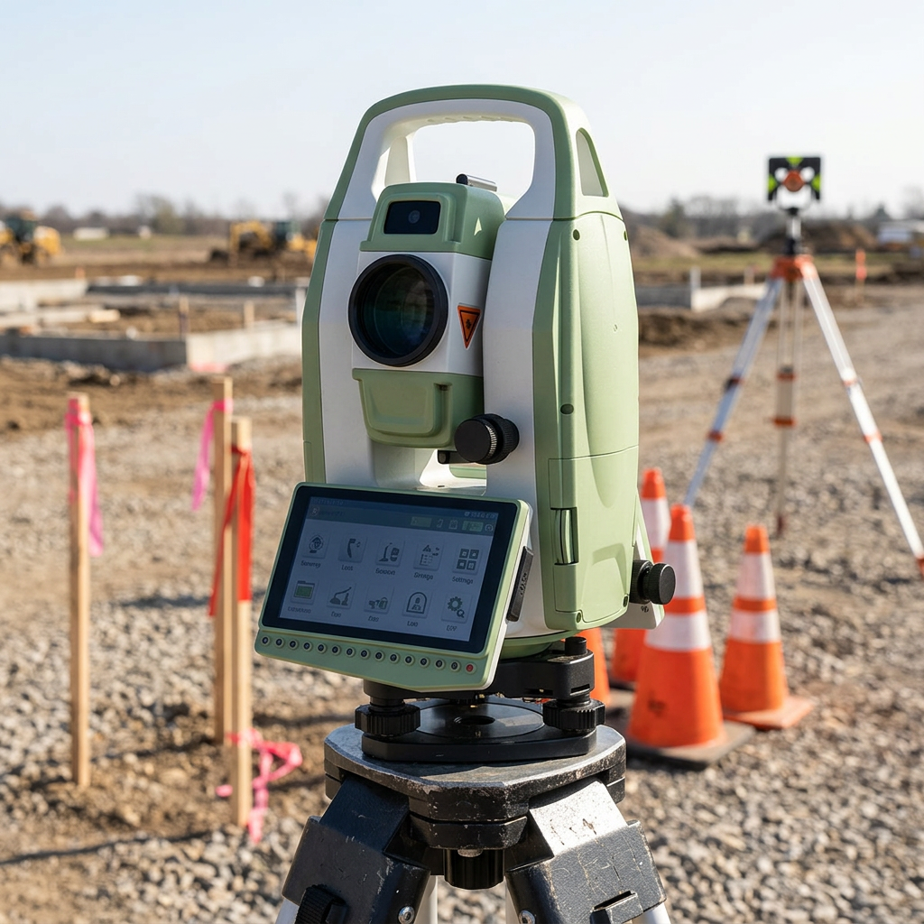
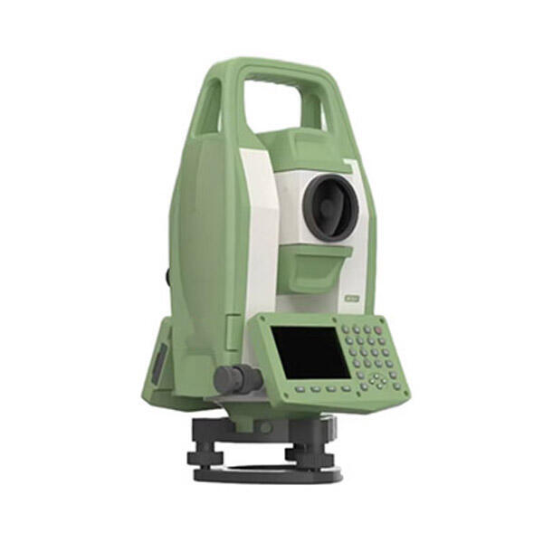
Total station tools represent cutting-edge surveying instruments that revolutionize land measurement and construction projects. These sophisticated devices combine electronic distance measurement, angle measurement, and data processing capabilities into one comprehensive unit. Modern total station tools integrate advanced laser technology with precision optical systems to deliver unmatched accuracy in surveying applications. The fundamental operation relies on electromagnetic wave transmission to measure distances while simultaneously capturing horizontal and vertical angles with exceptional precision. These instruments feature high-resolution displays that present real-time measurements and calculations, enabling surveyors to make immediate decisions in the field. Total station tools incorporate powerful microprocessors that perform complex trigonometric calculations automatically, eliminating manual computation errors and significantly reducing project timelines. The technological architecture includes sophisticated software platforms that support various surveying methodologies, from basic boundary surveys to complex topographical mapping. Many total station tools offer wireless connectivity options, allowing seamless data transfer to tablets, smartphones, and office computers for immediate processing and analysis. The rugged construction ensures reliable performance in challenging environmental conditions, with weatherproof housings protecting sensitive electronic components from dust, moisture, and temperature fluctuations. Advanced models feature motorized drives that enable automated target tracking and robotic operation, transforming single-operator workflows and enhancing productivity. The applications span multiple industries including construction, engineering, mining, archaeology, and infrastructure development. Construction professionals utilize total station tools for precise building layout, foundation positioning, and structural alignment verification. Civil engineers depend on these instruments for road design, utility mapping, and environmental monitoring projects. The versatility extends to specialized applications such as monitoring structural deformations, tracking geological movements, and creating detailed 3D site models for architectural visualization.

New Product Releases

Total station tools deliver remarkable time savings that directly impact project profitability and completion schedules. Traditional surveying methods require multiple instruments and extensive manual calculations, while total station tools streamline the entire process into a single, efficient workflow. Users experience immediate productivity gains as these devices eliminate the need for separate theodolites, levels, and measuring tapes. The integrated design reduces equipment transportation costs and setup time, allowing survey teams to cover more ground in less time. Accuracy represents another compelling advantage, with modern total station tools achieving measurement precision within millimeters over hundreds of meters. This exceptional accuracy prevents costly construction errors and reduces the need for rework, saving both time and materials. The automated calculation features eliminate human error from trigonometric computations, ensuring consistent results across different operators and project phases. Data management capabilities provide substantial operational benefits through electronic storage and instant transfer options. Survey teams can capture thousands of data points without manual recording, reducing paperwork and transcription errors while creating permanent digital records. The ability to export data directly to CAD software and project management platforms accelerates the design process and improves collaboration between field and office teams. Weather resistance ensures continuous operation in adverse conditions, maintaining project momentum regardless of environmental challenges. Many total station tools function reliably in rain, dust, and extreme temperatures, conditions that would halt traditional surveying operations. The durability reduces maintenance costs and equipment downtime, providing excellent return on investment over extended periods. User-friendly interfaces make these sophisticated instruments accessible to operators with varying experience levels. Intuitive menu systems and guided measurement procedures reduce training requirements and minimize the learning curve for new team members. Advanced models offer customizable workflows that adapt to specific project requirements, further enhancing operational efficiency. The versatility of total station tools extends their value across multiple applications within the same organization. A single instrument can handle boundary surveys, construction layout, topographic mapping, and monitoring applications, reducing the need for specialized equipment purchases. This flexibility maximizes equipment utilization and provides greater financial returns for surveying firms and construction companies.

Latest News

How GNSS RTK Systems Deliver High-Precision Results

27

Nov

How GNSS RTK Systems Deliver High-Precision Results

Modern surveying and positioning applications demand exceptional accuracy that traditional GPS systems simply cannot deliver. Global Navigation Satellite System Real-Time Kinematic (GNSS RTK Systems) have revolutionized precision positioning by provi...
View More
How Does a Digital Level Improve Accuracy in Construction Measurements?

13

Jan

How Does a Digital Level Improve Accuracy in Construction Measurements?

Construction professionals understand that precision forms the foundation of every successful project. Modern building techniques demand measurement accuracy that surpasses traditional methods, making the digital level an indispensable tool for contr...
View More
How Does RTK GPS Reduce Errors in Professional Survey Work?

13

Jan

How Does RTK GPS Reduce Errors in Professional Survey Work?

Professional surveying demands precision that can make the difference between project success and costly mistakes. Traditional GPS systems, while revolutionary, often fall short of the accuracy requirements needed for construction, engineering, and l...
View More
Why Are Digital Levels Preferred Over Traditional Bubble Levels?

11

Feb

Why Are Digital Levels Preferred Over Traditional Bubble Levels?

The construction and engineering industries have witnessed a significant transformation in measurement tools over the past decade. Among these advancements, digital levels have emerged as the preferred choice for professionals who demand precision, e...
View More

Get a Free Quote

Our representative will contact you soon.
Email
Name
Company Name
Message
0/1000

total station tools

Precision Laser Distance Measurement Technology

Precision Laser Distance Measurement Technology

Total station tools incorporate state-of-the-art laser distance measurement technology that revolutionizes surveying accuracy and efficiency. The advanced laser systems emit precisely controlled electromagnetic pulses that travel to reflective targets and return to the instrument, where sophisticated processors calculate distances with remarkable precision. Modern total station tools achieve distance measurement accuracy within 1-2 millimeters plus 2 parts per million of the measured distance, ensuring exceptional reliability for critical construction and engineering applications. The laser technology operates effectively across extensive ranges, with many models capable of measuring distances up to several kilometers under optimal conditions, making them suitable for large-scale infrastructure projects and boundary surveys. The non-contact measurement approach eliminates errors associated with traditional chain and tape measurements, while the instantaneous results accelerate field operations significantly. Advanced prism tracking capabilities allow total station tools to automatically locate and lock onto reflective targets, maintaining continuous measurement even when targets move slightly due to wind or vibration. The laser systems incorporate multiple measurement modes including single-shot, continuous, and tracking modes that adapt to different surveying requirements and environmental conditions. Temperature and atmospheric pressure compensation features ensure consistent accuracy across varying weather conditions, automatically adjusting calculations to account for environmental factors that affect electromagnetic wave propagation. The integration of coaxial laser design places the measurement beam precisely along the optical axis of the telescope, eliminating parallax errors and ensuring that distance measurements correspond exactly to the targeted point. Many total station tools feature dual-laser systems that provide both visible red lasers for easy target identification and invisible infrared lasers for extended range capabilities. The rapid measurement cycle times, often completing distance calculations in less than one second, enable surveyors to capture thousands of data points efficiently throughout a project day. Quality laser diodes and precision optics maintain measurement consistency over the instrument's operational lifetime, providing reliable performance that justifies the initial investment through years of dependable service.
Integrated Data Processing And Management Systems

Integrated Data Processing And Management Systems

Total station tools feature comprehensive data processing and management systems that transform raw field measurements into actionable project information. These sophisticated systems incorporate powerful microprocessors and specialized surveying software that perform complex calculations automatically, eliminating manual computation errors and accelerating project workflows. The integrated databases can store thousands of measurement points with associated attributes such as point names, descriptions, and coordinate systems, creating comprehensive digital records of surveying activities. Advanced coordinate geometry functions enable total station tools to calculate areas, volumes, slopes, and elevations directly in the field, providing immediate feedback on project parameters and design compliance. The systems support multiple coordinate systems including local grids, state plane coordinates, and GPS-compatible formats, ensuring seamless integration with existing project data and mapping standards. Real-time quality control features alert operators to potential errors or inconsistencies in measurements, enabling immediate corrections that prevent data quality issues from propagating through project deliverables. The data management capabilities extend to automatic backup systems that preserve critical measurements against accidental loss or equipment failure. Many total station tools incorporate removable storage media and wireless connectivity options that facilitate secure data transfer to office systems and cloud-based project management platforms. The software architectures support customizable data formats and export options that accommodate various CAD programs, GIS systems, and construction management software packages. Advanced models offer field-to-finish capabilities that generate finished drawings and reports directly from raw survey data, reducing office processing time and accelerating project delivery schedules. The integrated systems maintain detailed measurement logs that document surveying procedures and instrument settings, supporting quality assurance protocols and professional certification requirements. Database query functions allow surveyors to quickly locate and review specific measurements or point groups, facilitating efficient data verification and project coordination activities. The processing power enables real-time stake-out calculations that guide construction crews to precise locations based on design coordinates, ensuring accurate implementation of engineering plans and architectural specifications throughout the construction process.
Robotic Operation And Automated Tracking Capabilities

Robotic Operation And Automated Tracking Capabilities

Total station tools equipped with robotic operation and automated tracking capabilities represent the pinnacle of surveying technology innovation, enabling single-operator workflows that dramatically improve productivity and reduce labor costs. These advanced systems incorporate motorized horizontal and vertical drives that respond to remote control commands, allowing surveyors to operate instruments from any location within the measurement range. The automated tracking technology uses active infrared communication between the total station tools and specialized prism targets to maintain continuous lock-on capabilities, even as targets move throughout the survey area. This revolutionary approach eliminates the need for dedicated instrument operators, enabling survey crews to accomplish complex projects with reduced personnel while maintaining exceptional accuracy standards. The robotic systems feature sophisticated target recognition algorithms that distinguish between multiple prisms operating simultaneously in the same area, preventing measurement confusion and ensuring data integrity in busy construction environments. Advanced search functions automatically locate lost targets by systematically scanning predefined areas, minimizing downtime when prisms move outside the instrument's field of view. The remote control units provide intuitive interfaces that allow surveyors to initiate measurements, adjust instrument settings, and review data from distances up to several hundred meters from the total station tools. Long-range communication capabilities ensure reliable operation across large construction sites and challenging terrain where traditional surveying methods would require multiple instrument setups. The robotic operation includes programmable measurement routines that execute complex surveying procedures automatically, reducing operator fatigue and ensuring consistent data collection protocols throughout extended field sessions. Power management systems optimize battery consumption during robotic operation, extending field time and reducing the frequency of battery changes or recharging cycles. The automated features support various surveying applications including topographic mapping, construction layout, monitoring surveys, and as-built documentation with equal effectiveness. Safety enhancements include obstacle detection systems that prevent instrument damage during automated movements and emergency stop functions that halt operation immediately when hazardous conditions develop. The integration of robotic capabilities with data processing systems creates seamless workflows where measurements flow automatically from field collection through data processing to final deliverable generation, establishing new standards for surveying efficiency and project completion speed.

Get a Free Quote

Our representative will contact you soon.
Email
Name
Company Name
Message
0/1000