Professional Total Station Survey Instrument - Precision Surveying Equipment for Modern Applications

All Categories

total station survey instrument

The total station survey instrument represents a revolutionary advancement in modern surveying technology, combining the functionality of an electronic theodolite with an electronic distance meter (EDM) in a single, integrated unit. This sophisticated surveying equipment has transformed the way professionals conduct land surveys, construction layout, and topographic mapping projects. The total station survey instrument operates by measuring both horizontal and vertical angles with exceptional precision while simultaneously calculating distances to target points using advanced laser or infrared technology. These measurements are then processed internally to determine three-dimensional coordinates of surveyed points, eliminating the need for separate instruments and reducing potential errors. Modern total station survey instruments feature digital displays, internal data storage capabilities, and advanced computing power that allows for real-time coordinate calculations and immediate field adjustments. The instrument typically consists of a telescope for target sighting, electronic angle measurement systems, distance measurement components, and a sophisticated onboard computer system. Many contemporary models incorporate reflectorless measurement technology, enabling distance measurements to any visible surface without requiring a prism or reflective target. This capability significantly expands the versatility and efficiency of surveying operations. The total station survey instrument also features automatic target recognition (ATR) technology in premium models, which can automatically locate and lock onto prism targets, further enhancing measurement speed and accuracy. Built-in data logging capabilities allow surveyors to record measurements directly in the field, while wireless connectivity options enable seamless data transfer to office computers or cloud-based systems. The rugged construction of these instruments ensures reliable performance in challenging environmental conditions, with many models offering IP ratings for dust and water resistance. Advanced total station survey instruments also include GPS integration capabilities, allowing for enhanced positioning accuracy and simplified coordinate system management across large survey projects.

New Products

The total station survey instrument delivers exceptional value through its comprehensive measurement capabilities and user-friendly operation. This advanced surveying equipment significantly reduces project completion times by combining multiple measurement functions in one device, eliminating the need to carry and set up separate theodolites and distance meters. Professional surveyors experience dramatically improved accuracy rates, with modern total station survey instruments achieving measurement precision within millimeters for both distance and angular measurements. The integrated computing system performs complex calculations automatically, reducing human error and providing instant results that can be verified immediately in the field. Data collection becomes streamlined and efficient, as the total station survey instrument stores all measurements digitally, eliminating handwritten field notes and reducing transcription errors. The reflectorless measurement capability allows surveyors to measure distances to inaccessible points such as building corners, overhead structures, or dangerous terrain without requiring physical access to place targets. This feature alone can save hours of setup time and improve worker safety on construction sites and challenging survey locations. Battery technology in modern total station survey instruments provides extended operational periods, often lasting full working days without requiring recharging, ensuring uninterrupted productivity. The rugged design withstands harsh weather conditions, temperature extremes, and construction site environments, providing reliable performance when other equipment might fail. Automatic target recognition features in premium models further enhance efficiency by reducing the time required to acquire and track survey targets. The learning curve for operating total station survey instruments remains manageable, with intuitive interfaces and comprehensive training programs available from manufacturers. Cost-effectiveness becomes apparent through reduced labor requirements, as fewer personnel are needed to complete complex surveying tasks compared to traditional methods. The versatility of total station survey instruments makes them suitable for diverse applications, from small residential lot surveys to large infrastructure projects, providing excellent return on investment. Integration capabilities with CAD software and GPS systems create seamless workflows from field measurement to final drawing production, reducing project timelines and improving client satisfaction. Modern total station survey instruments also feature advanced communication options, including Bluetooth and wireless connectivity, enabling real-time data sharing between field crews and office personnel.

Tips And Tricks

GNSS RTK: The Ultimate Guide to Real-Time Kinematic Surveying

27

Nov

GNSS RTK: The Ultimate Guide to Real-Time Kinematic Surveying

Real-Time Kinematic (RTK) technology has revolutionized the field of surveying by providing centimeter-level accuracy in positioning measurements. This advanced Global Navigation Satellite System (GNSS) technique enables surveyors, construction profe...
View More
Choosing the Best GNSS RTK System for Your Project

27

Nov

Choosing the Best GNSS RTK System for Your Project

When precision positioning is critical for your surveying, construction, or engineering project, selecting the right GNSS RTK system becomes a pivotal decision that can determine project success. Modern surveying demands centimeter-level accuracy, re...
View More
What Should Engineers Check Before Choosing an RTK System?

22

Dec

What Should Engineers Check Before Choosing an RTK System?

Selecting the right RTK system represents one of the most critical decisions in modern surveying and construction projects. Engineers must navigate through numerous technical specifications, accuracy requirements, and operational considerations to en...
View More
What Should Buyers Compare When Sourcing RTK GPS Equipment?

13

Jan

What Should Buyers Compare When Sourcing RTK GPS Equipment?

Modern construction, surveying, and agricultural operations increasingly rely on precise positioning technology to achieve millimeter-level accuracy in their work. When sourcing RTK GPS equipment, buyers face numerous technical specifications, featur...
View More

Get a Free Quote

Our representative will contact you soon.
Email
Name
Company Name
Message
0/1000

total station survey instrument

Precision Measurement Technology

Precision Measurement Technology

The precision measurement technology integrated into modern total station survey instruments sets new standards for accuracy and reliability in professional surveying applications. These sophisticated instruments utilize advanced electronic angle measurement systems that can achieve accuracy levels of 1 arc second or better, translating to millimeter-level precision over typical surveying distances. The distance measurement component employs state-of-the-art laser technology or infrared EDM systems capable of measuring ranges from a few meters to several kilometers with accuracy typically within 1-3 millimeters plus 1-2 parts per million of the measured distance. This exceptional precision results from multiple technological innovations, including temperature and atmospheric pressure compensation systems that automatically adjust measurements for environmental conditions that could affect accuracy. The total station survey instrument incorporates dual-axis compensators that automatically correct for minor instrument leveling errors, ensuring that measurements remain accurate even when the instrument is not perfectly level. Advanced signal processing algorithms filter out noise and interference, while multiple measurement averaging functions allow users to achieve even higher accuracy levels when required. The precision measurement technology also includes sophisticated targeting systems with high-resolution telescopes offering magnification ranges typically between 20x to 40x, enabling accurate sighting of targets at considerable distances. Many premium total station survey instruments feature advanced optics with ED (Extra-low Dispersion) glass elements that minimize chromatic aberration and provide sharp, clear images even in challenging lighting conditions. The electronic measurement systems operate continuously during observations, providing real-time feedback on measurement quality and allowing operators to optimize their positioning for best results. Temperature sensors and barometric pressure sensors built into the total station survey instrument ensure that environmental corrections are applied automatically, maintaining measurement accuracy throughout varying field conditions. The precision measurement technology extends to the internal computing systems, which use double-precision arithmetic for all coordinate calculations, ensuring that computational errors do not compromise the inherent accuracy of the measurement systems.
Integrated Data Management System

Integrated Data Management System

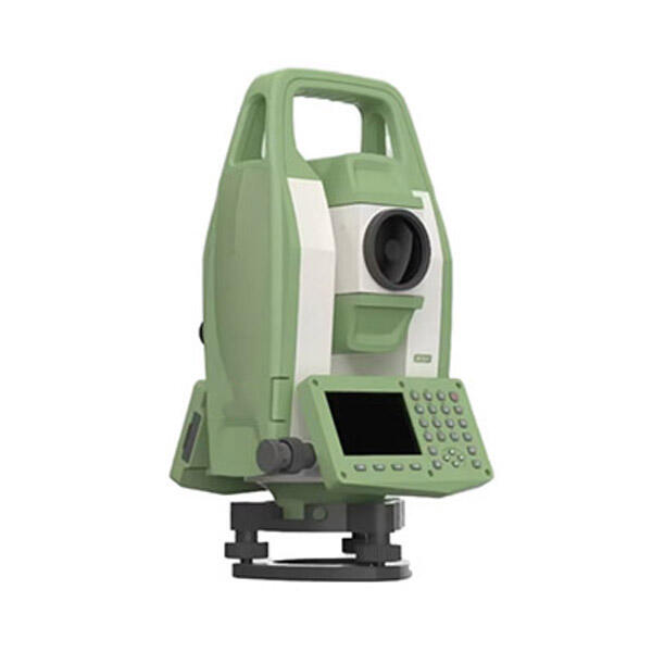
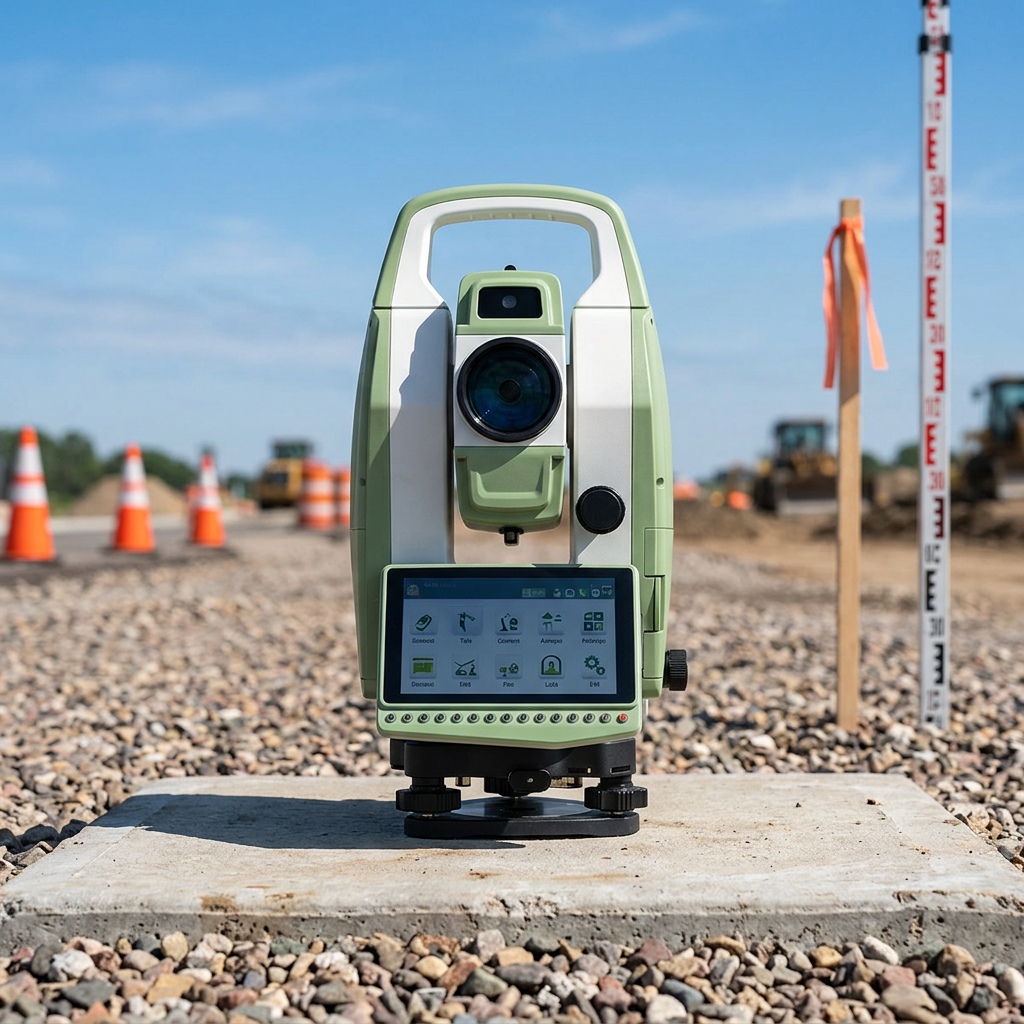
The integrated data management system represents one of the most valuable features of modern total station survey instruments, transforming how surveying professionals collect, process, and utilize field measurement data. This comprehensive system begins with robust internal memory capable of storing thousands of survey points, complete with point identifiers, coordinates, descriptive codes, and measurement metadata. The data management architecture allows users to organize surveys into separate job files, making it easy to manage multiple projects simultaneously while maintaining clear data separation and preventing accidental data mixing. Advanced total station survey instruments incorporate sophisticated coding systems that enable automatic point classification and feature identification during data collection, streamlining the transition from field measurements to final drawings and maps. The system supports customizable data formats, allowing compatibility with popular CAD and GIS software packages, while also maintaining industry-standard formats for maximum flexibility in data processing workflows. Real-time coordinate calculation and display capabilities provide immediate feedback to surveyors, enabling on-the-spot quality control and error detection before leaving survey locations. The integrated data management system includes comprehensive search and retrieval functions, making it easy to locate and review specific measurements or survey points from extensive datasets. Export capabilities support multiple file formats, including ASCII text, DXF, and specialized surveying formats, ensuring seamless integration with office-based processing software. Many total station survey instruments feature wireless data transmission capabilities, enabling real-time data sharing between field crews and office personnel for enhanced project coordination and immediate data backup. The system also incorporates data validation routines that check for common surveying errors such as duplicate point numbers, impossible measurements, or inconsistent angle closures, alerting operators to potential issues before they become costly problems. Advanced models include GPS integration within their data management systems, allowing for coordinate transformations and enhanced positioning capabilities. The data management system maintains detailed measurement logs, including time stamps, environmental conditions, and measurement parameters, providing comprehensive audit trails for quality assurance and project documentation purposes.
Versatile Application Capabilities

Versatile Application Capabilities

The versatile application capabilities of total station survey instruments make them indispensable tools across numerous professional fields and project types, demonstrating exceptional adaptability to diverse surveying challenges and requirements. Construction professionals rely on these instruments for precise site layout, building positioning, and dimensional verification throughout project phases, from initial site preparation through final as-built documentation. The total station survey instrument excels in topographic mapping applications, efficiently collecting elevation data and terrain features to create detailed contour maps and digital terrain models for engineering design and environmental analysis. Land surveying professionals utilize these instruments for boundary surveys, subdivision layout, and property line establishment, taking advantage of their precision and legal-grade accuracy for important land ownership documentation. Infrastructure development projects benefit from the total station survey instrument's ability to perform alignment surveys for roads, railways, and utility corridors, ensuring that construction follows design specifications with minimal deviation. Mining and quarrying operations employ these instruments for volume calculations, stockpile monitoring, and safety inspections in challenging environments where traditional surveying methods would be impractical or dangerous. Environmental monitoring applications leverage the reflectorless measurement capabilities to survey sensitive areas without disturbing ecosystems while collecting data for habitat mapping and conservation planning. Architectural restoration projects utilize total station survey instruments to create precise as-built drawings of historical structures, capturing intricate details necessary for preservation and renovation work. The instruments prove valuable in forensic applications, providing accurate measurements for accident reconstruction, crime scene documentation, and legal evidence collection. Industrial facility management benefits from these versatile tools for equipment positioning, maintenance planning, and spatial analysis of complex manufacturing environments. Deformation monitoring projects rely on the precision measurement capabilities to detect minute structural movements in dams, bridges, and buildings over extended periods. Archaeological excavations employ total station survey instruments to precisely document artifact locations and site features, creating detailed records essential for scientific research and cultural preservation. The instruments adapt to specialized applications such as tunnel surveying, where precise alignment control is critical for meeting breakthrough tolerances, and marine surveying applications for port facilities and coastal engineering projects.

Get a Free Quote

Our representative will contact you soon.
Email
Name
Company Name
Message
0/1000