Total Station Instrument: Professional Surveying Equipment for Precision Measurement and Data Collection

All Categories

total station instrument

The total station instrument represents a revolutionary advancement in surveying and construction technology, combining electronic distance measurement, digital theodolite capabilities, and sophisticated data processing into one comprehensive device. This electronic surveying instrument integrates angle measurement, distance measurement, and data recording functions, making it an indispensable tool for modern surveying professionals. The total station instrument operates by measuring horizontal and vertical angles with high precision while simultaneously calculating distances using electromagnetic waves. Professional surveyors rely on this sophisticated equipment to establish precise coordinates, create detailed topographic maps, and perform complex construction layout tasks with exceptional accuracy. The device features a built-in computer system that automatically processes measurements, performs coordinate calculations, and stores data for future analysis. Modern total station instruments incorporate advanced laser technology, enabling users to measure distances up to several kilometers with millimeter-level precision. The instrument's electronic display provides real-time feedback, showing measurements, coordinates, and calculated results instantly. These devices typically include motorized targeting systems that can automatically locate and track prisms, significantly reducing manual labor and human error. The total station instrument connects seamlessly with GPS systems, creating a powerful combination for large-scale surveying projects. Data collection capabilities allow surveyors to record thousands of measurements, which can be exported to computer-aided design software for detailed analysis and mapping. Weather-resistant construction ensures reliable operation in challenging field conditions, while rechargeable battery systems provide extended operational time. The versatility of the total station instrument extends beyond traditional surveying, supporting applications in construction monitoring, deformation analysis, and engineering surveys. Advanced models feature reflectorless measurement capabilities, enabling distance measurement to any surface without requiring special targets.

New Product Recommendations

The total station instrument delivers exceptional time savings compared to traditional surveying methods, completing complex measurement tasks that previously required multiple instruments and extensive calculations. Surveyors can establish control networks, perform detailed topographic surveys, and execute precise construction layouts using a single device, eliminating the need for separate theodolites, distance meters, and calculation tools. The automated data collection feature reduces field time significantly, as measurements are instantly recorded and processed without manual note-taking or repetitive calculations. This efficiency translates directly into cost savings for surveying projects, allowing professionals to complete more work with fewer resources and reduced labor costs. Accuracy represents another major advantage of the total station instrument, with precision levels reaching arc-seconds for angles and millimeters for distances. The electronic measurement system eliminates human reading errors common with optical instruments, while built-in error correction algorithms compensate for atmospheric conditions and instrument imperfections. Digital data storage prevents transcription errors and ensures measurement integrity throughout the project lifecycle. The total station instrument enhances safety by reducing the need for personnel in hazardous areas, as reflectorless measurement capabilities allow operators to survey dangerous locations from safe distances. Weather resistance and robust construction ensure reliable operation in extreme conditions, minimizing project delays and equipment downtime. User-friendly interfaces with intuitive menu systems enable quick training for new operators, reducing learning curves and increasing productivity. Battery-powered operation provides freedom from external power sources, supporting extended field work in remote locations. The instrument's versatility adapts to various surveying applications, from simple boundary surveys to complex engineering projects, making it suitable for diverse professional needs. Integration capabilities with modern software systems streamline workflow processes, allowing seamless data transfer from field measurements to office analysis and design applications. Real-time coordinate display enables immediate quality control, helping surveyors identify and correct errors during data collection rather than discovering problems later during post-processing.

Latest News

GNSS RTK: The Ultimate Guide to Real-Time Kinematic Surveying

27

Nov

GNSS RTK: The Ultimate Guide to Real-Time Kinematic Surveying

Real-Time Kinematic (RTK) technology has revolutionized the field of surveying by providing centimeter-level accuracy in positioning measurements. This advanced Global Navigation Satellite System (GNSS) technique enables surveyors, construction profe...
View More
Choosing the Best GNSS RTK System for Your Project

27

Nov

Choosing the Best GNSS RTK System for Your Project

When precision positioning is critical for your surveying, construction, or engineering project, selecting the right GNSS RTK system becomes a pivotal decision that can determine project success. Modern surveying demands centimeter-level accuracy, re...
View More
Why Do Mapping Teams Prefer RTK for Real-Time Positioning Tasks?

22

Dec

Why Do Mapping Teams Prefer RTK for Real-Time Positioning Tasks?

Modern mapping teams face unprecedented demands for precision and speed in their surveying operations. The evolution of positioning technologies has revolutionized how professionals approach field data collection, with RTK for real-time positioning e...
View More
Why Is RTK GNSS Essential for High-Accuracy Industrial Positioning?

22

Dec

Why Is RTK GNSS Essential for High-Accuracy Industrial Positioning?

In today's rapidly evolving industrial landscape, precise positioning has become the cornerstone of operational excellence across multiple sectors. RTK GNSS technology represents a quantum leap forward in positioning accuracy, delivering centimeter-l...
View More

Get a Free Quote

Our representative will contact you soon.
Email
Name
Company Name
Message
0/1000

total station instrument

Advanced Precision Technology for Unmatched Accuracy

Advanced Precision Technology for Unmatched Accuracy

The total station instrument incorporates cutting-edge precision technology that delivers measurement accuracy superior to traditional surveying methods, establishing new standards for professional surveying applications. The sophisticated electronic distance measurement system utilizes infrared laser technology combined with phase-shift measurement principles, achieving distance accuracy within 1-2 millimeters plus 2 parts per million over measurement ranges extending several kilometers. Angular measurements reach precision levels of 1 to 5 arc-seconds, depending on the instrument grade, ensuring that surveyors can establish control networks and perform layout work with confidence in their results. The instrument's dual-axis compensator automatically corrects for minor leveling errors, maintaining measurement accuracy even when the device is not perfectly level. This advanced compensation system eliminates a significant source of error common in traditional surveying, where manual leveling procedures often introduce inaccuracies. Temperature and pressure sensors built into the total station instrument automatically adjust measurements for atmospheric conditions, compensating for refraction effects that can significantly impact distance measurements over long ranges. The precision technology extends to the instrument's servo-driven targeting system, which can automatically locate and lock onto prisms with sub-millimeter accuracy, ensuring consistent and repeatable measurements throughout extended surveying sessions. Multiple measurement modes allow operators to optimize accuracy for specific applications, whether performing rapid topographic mapping or executing precise construction layout requiring maximum precision. The total station instrument's precision capabilities enable professionals to meet increasingly stringent accuracy requirements in modern construction and engineering projects, where millimeter-level tolerances are becoming standard. Quality control features provide real-time accuracy assessment, alerting operators to potential measurement issues and ensuring data integrity. This advanced precision technology ultimately translates into higher quality deliverables, reduced rework, and increased client confidence in surveying results.
Comprehensive Data Management and Integration Solutions

Comprehensive Data Management and Integration Solutions

The total station instrument features sophisticated data management capabilities that revolutionize how surveying professionals collect, store, and process measurement information, creating seamless workflows from field data collection through final project delivery. The instrument's internal memory can store thousands of measurement points, complete with descriptive codes, time stamps, and coordinate information, eliminating the need for manual field books and reducing transcription errors. Advanced data organization features allow surveyors to create multiple job files, organize measurements by project areas, and implement standardized coding systems for efficient post-processing. The total station instrument supports various data formats including industry-standard formats compatible with major computer-aided design and geographic information systems software, ensuring seamless data transfer and integration. Real-time data processing capabilities perform coordinate calculations, area and volume computations, and geometric analysis directly in the field, providing immediate feedback on survey progress and quality. The instrument's communication interfaces, including USB ports, Bluetooth connectivity, and some models featuring cellular data capabilities, enable instant data transfer to office computers and cloud-based storage systems. This connectivity allows project managers to monitor survey progress remotely and provides backup security for critical measurement data. The total station instrument's data management system includes powerful search and filtering functions, enabling operators to quickly locate specific measurements or review data quality during field operations. Export capabilities generate standardized reports, coordinate listings, and data summaries that integrate directly with project documentation requirements. Advanced models feature integration with Global Navigation Satellite Systems, combining terrestrial measurements with satellite positioning data for enhanced coordinate accuracy and expanded measurement capabilities. The comprehensive data management system reduces post-processing time significantly, as measurements are pre-organized and formatted for immediate use in design and analysis applications. Quality assurance features track measurement statistics, identify potential errors, and provide detailed audit trails for professional documentation requirements.
Versatile Applications Across Multiple Industries

Versatile Applications Across Multiple Industries

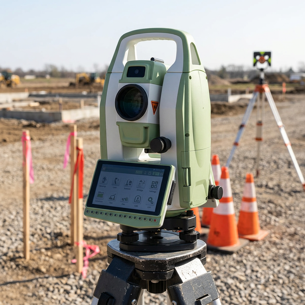
The total station instrument demonstrates remarkable versatility, serving diverse industries and applications ranging from traditional land surveying to specialized engineering projects, making it an essential investment for surveying professionals seeking to expand their service offerings. Construction industry applications include precise building layout, structural monitoring, and as-built documentation, where the instrument's accuracy and efficiency significantly improve project timelines and quality control. The total station instrument excels in infrastructure development projects, supporting highway design, railway construction, and utilities installation with precise alignment control and grade management. Mining operations utilize these instruments for pit surveying, volume calculations, and safety monitoring, where accurate measurements are critical for operational planning and regulatory compliance. Archaeological investigations benefit from the total station instrument's ability to precisely document artifact locations and site features, creating detailed spatial records essential for research and preservation efforts. Environmental monitoring applications include deformation surveys of dams, bridges, and slopes, where the instrument's precision enables detection of minute structural movements that could indicate safety concerns. The total station instrument supports property boundary surveys, subdivision planning, and legal documentation requirements, providing the accuracy needed for property disputes and development approvals. Topographic mapping applications utilize the instrument's rapid measurement capabilities to create detailed terrain models for flood studies, drainage design, and landscape planning. Industrial applications include machinery alignment, facility layout, and quality control measurements in manufacturing environments where precision positioning is critical for operational efficiency. The instrument's reflectorless measurement capabilities expand applications to include facade surveys, structural inspections, and measurements in hazardous areas where traditional surveying methods would be impractical or unsafe. Forensic applications utilize the total station instrument for accident reconstruction, crime scene documentation, and legal evidence collection, where measurement accuracy and documentation integrity are paramount. The versatility extends to specialized applications including antenna positioning for telecommunications, solar panel installation alignment, and precision agriculture applications where accurate field mapping supports optimal crop management strategies.

Get a Free Quote

Our representative will contact you soon.
Email
Name
Company Name
Message
0/1000