Professional Surveying GNSS Receivers - High Precision GPS Equipment for Land Surveying

All Categories

surveying gnss receiver

The surveying GNSS receiver represents a revolutionary advancement in modern land surveying and geospatial data collection. This sophisticated device harnesses signals from multiple satellite constellations including GPS, GLONASS, Galileo, and BeiDou to deliver exceptional positioning accuracy for professional surveying applications. Unlike basic consumer GPS devices, a surveying GNSS receiver incorporates advanced technologies that enable centimeter-level precision, making it indispensable for construction projects, boundary surveys, topographical mapping, and infrastructure development. The core functionality of a surveying GNSS receiver centers on its ability to simultaneously track signals from numerous satellites while applying real-time kinematic processing techniques. This multi-constellation approach significantly enhances signal availability and positioning reliability, particularly in challenging environments such as urban canyons or heavily forested areas where satellite visibility may be limited. Modern surveying GNSS receivers feature robust antenna systems designed to minimize multipath effects and electromagnetic interference, ensuring consistent performance across diverse field conditions. The technological architecture of these devices typically includes dual-frequency capability, allowing the receiver to process both L1 and L2 satellite signals for improved accuracy and faster convergence times. Many advanced models also support L5 frequencies, providing additional redundancy and enhanced precision for critical surveying tasks. The integrated processing unit handles complex calculations in real-time, automatically compensating for atmospheric delays, satellite clock errors, and other systematic biases that could compromise measurement accuracy. Professional surveying GNSS receivers are engineered to withstand harsh field conditions, featuring ruggedized housings with IP67 or IP68 ratings for dust and water resistance. These devices often incorporate shock-resistant designs and operate effectively across extended temperature ranges, ensuring reliable performance in extreme weather conditions. The user interface typically includes intuitive controls and bright displays that remain readable in direct sunlight, while wireless connectivity options enable seamless data transfer and remote monitoring capabilities for enhanced workflow efficiency.

New Product Releases

Professional surveyors benefit tremendously from the exceptional accuracy that surveying GNSS receivers provide, achieving positioning precision within one to two centimeters under optimal conditions. This level of accuracy eliminates the need for extensive traditional surveying methods, reducing project timelines and associated labor costs significantly. The ability to establish precise coordinates quickly and reliably transforms how surveying projects are executed, enabling faster decision-making and improved project outcomes. The surveying GNSS receiver dramatically increases field productivity by allowing surveyors to collect more data points in less time compared to conventional surveying instruments. Traditional methods often require complex setup procedures and line-of-sight measurements between multiple points, whereas GNSS technology enables direct positioning from any location with adequate satellite visibility. This efficiency gain translates to substantial cost savings for surveying firms and their clients, as projects can be completed with fewer personnel and reduced equipment mobilization time. Real-time data processing capabilities represent another significant advantage of modern surveying GNSS receivers. Surveyors can immediately verify measurement quality and make necessary adjustments in the field, preventing costly return trips and ensuring data integrity from the outset. The instant feedback provided by these devices helps maintain quality control standards while reducing the potential for human error during data collection activities. The versatility of surveying GNSS receivers makes them suitable for diverse applications ranging from large-scale infrastructure projects to precise property boundary determinations. These devices seamlessly integrate with existing surveying software platforms, enabling smooth data workflows and compatibility with various CAD and GIS systems. This integration capability streamlines the entire surveying process from field data collection through final deliverable preparation. Weather independence provides another compelling advantage, as surveying GNSS receivers continue operating effectively in conditions that would halt traditional surveying activities. Rain, snow, or fog do not significantly impact satellite signal reception, allowing surveys to proceed according to schedule regardless of weather variations. This reliability helps maintain project timelines and reduces weather-related delays that commonly affect conventional surveying operations. The surveying GNSS receiver also offers superior safety benefits by reducing the need for surveyors to access dangerous or difficult-to-reach locations. Remote positioning capabilities enable data collection from safe vantage points while maintaining accuracy requirements, protecting personnel from potential hazards associated with challenging terrain or high-traffic areas.

Practical Tips

How GNSS RTK Systems Deliver High-Precision Results

27

Nov

How GNSS RTK Systems Deliver High-Precision Results

Modern surveying and positioning applications demand exceptional accuracy that traditional GPS systems simply cannot deliver. Global Navigation Satellite System Real-Time Kinematic (GNSS RTK Systems) have revolutionized precision positioning by provi...
View More
Why Do Mapping Teams Prefer RTK for Real-Time Positioning Tasks?

22

Dec

Why Do Mapping Teams Prefer RTK for Real-Time Positioning Tasks?

Modern mapping teams face unprecedented demands for precision and speed in their surveying operations. The evolution of positioning technologies has revolutionized how professionals approach field data collection, with RTK for real-time positioning e...
View More
What Should Buyers Compare When Sourcing RTK GPS Equipment?

13

Jan

What Should Buyers Compare When Sourcing RTK GPS Equipment?

Modern construction, surveying, and agricultural operations increasingly rely on precise positioning technology to achieve millimeter-level accuracy in their work. When sourcing RTK GPS equipment, buyers face numerous technical specifications, featur...
View More
What Should You Evaluate Before Purchasing a Total Station?

13

Jan

What Should You Evaluate Before Purchasing a Total Station?

When investing in surveying equipment, selecting the right total station represents one of the most critical decisions for engineering professionals, construction teams, and surveying companies. A total station serves as the backbone of precise measu...
View More

Get a Free Quote

Our representative will contact you soon.
Email
Name
Company Name
Message
0/1000

surveying gnss receiver

Advanced Multi-Constellation Technology for Unmatched Reliability

Advanced Multi-Constellation Technology for Unmatched Reliability

The surveying GNSS receiver leverages cutting-edge multi-constellation technology that simultaneously tracks signals from GPS, GLONASS, Galileo, BeiDou, and other emerging satellite systems to deliver unprecedented reliability and accuracy in professional surveying applications. This comprehensive satellite coverage ensures optimal performance across all geographical regions and environmental conditions, providing surveyors with consistent results regardless of their location or project requirements. The multi-constellation approach significantly increases the number of available satellites at any given time, typically providing access to 20-30 satellites simultaneously compared to 8-12 satellites with single-constellation systems. This abundance of satellite signals dramatically improves positioning geometry and reduces dilution of precision, resulting in faster initialization times and more robust measurements throughout the surveying process. The surveying GNSS receiver intelligently selects the best available satellite combinations based on signal strength, elevation angles, and geometric distribution to optimize positioning accuracy and minimize measurement uncertainty. Advanced algorithms continuously monitor signal quality and automatically exclude satellites experiencing interference or atmospheric disturbances, maintaining measurement integrity even in challenging environments. The redundancy provided by multiple constellation support ensures continued operation even if individual satellites or entire constellations experience temporary outages, providing surveyors with confidence that their projects can proceed without interruption. This technology proves particularly valuable in urban environments where buildings and other structures may obstruct satellite signals, as the increased satellite availability improves the likelihood of maintaining adequate signal reception for accurate positioning. The surveying GNSS receiver also benefits from the diverse orbital characteristics of different satellite constellations, which provide improved coverage at various latitudes and times of day, ensuring consistent performance for surveying projects spanning multiple time zones or extended duration periods.
Centimeter-Level Precision with Real-Time Kinematic Processing

Centimeter-Level Precision with Real-Time Kinematic Processing

The surveying GNSS receiver achieves remarkable centimeter-level precision through sophisticated real-time kinematic processing technology that revolutionizes accuracy standards in professional surveying applications. This advanced positioning technique utilizes carrier phase measurements from multiple satellite frequencies to resolve integer ambiguities and deliver positioning solutions with horizontal accuracies typically ranging from 8-15 millimeters and vertical accuracies of 15-25 millimeters under favorable conditions. The real-time kinematic processing capability enables surveyors to obtain precise coordinates instantly in the field, eliminating the traditional requirement for post-processing and significantly accelerating project completion timelines. The surveying GNSS receiver employs dual or triple-frequency technology to enhance ambiguity resolution speed and reliability, often achieving fixed solutions within seconds rather than minutes required by older single-frequency systems. This rapid convergence capability proves essential for time-sensitive projects where surveying delays can impact overall construction schedules or project deadlines. The sophisticated algorithms within the surveying GNSS receiver continuously monitor measurement quality indicators and provide real-time feedback regarding solution reliability, enabling surveyors to make informed decisions about data acceptance and quality control procedures. Advanced atmospheric modeling techniques compensate for ionospheric and tropospheric delays that can degrade positioning accuracy, while multipath mitigation algorithms minimize the impact of reflected satellite signals in challenging environments. The surveying GNSS receiver also incorporates predictive positioning capabilities that maintain accuracy even during brief satellite signal interruptions, ensuring measurement continuity in partially obstructed environments. Quality assurance features include automatic outlier detection and statistical validation procedures that identify potentially problematic measurements before they can compromise survey integrity, providing surveyors with confidence in their results and reducing the likelihood of costly errors or rework requirements.
Rugged Design and Professional-Grade Durability for Field Excellence

Rugged Design and Professional-Grade Durability for Field Excellence

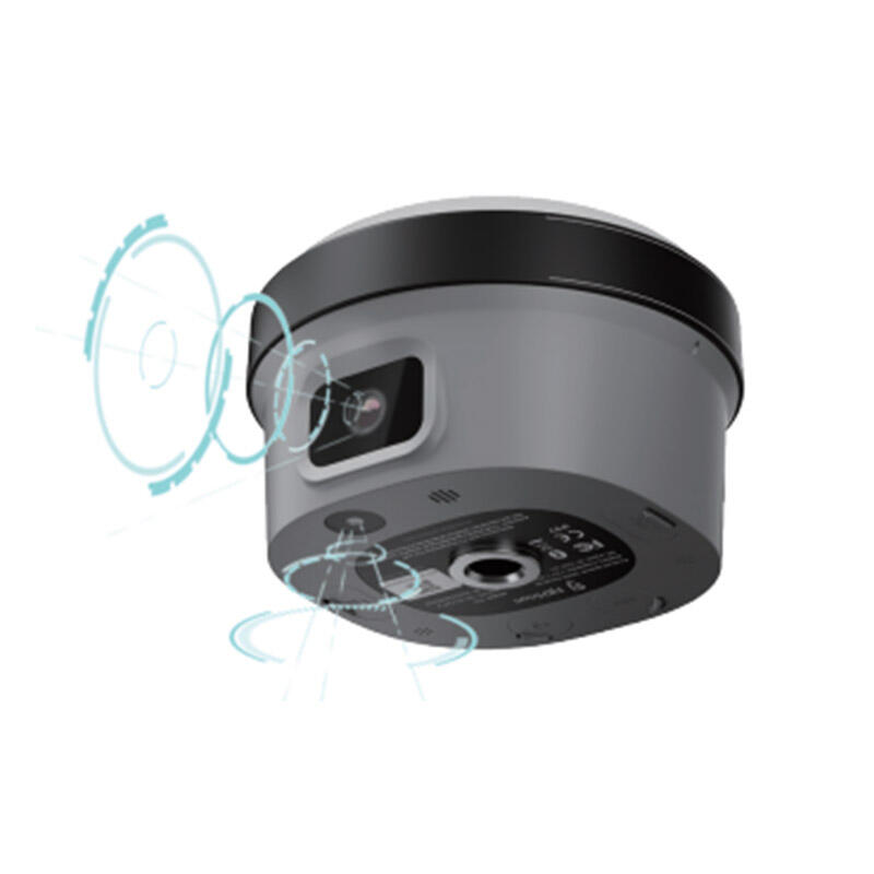
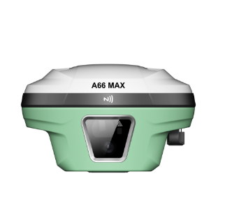
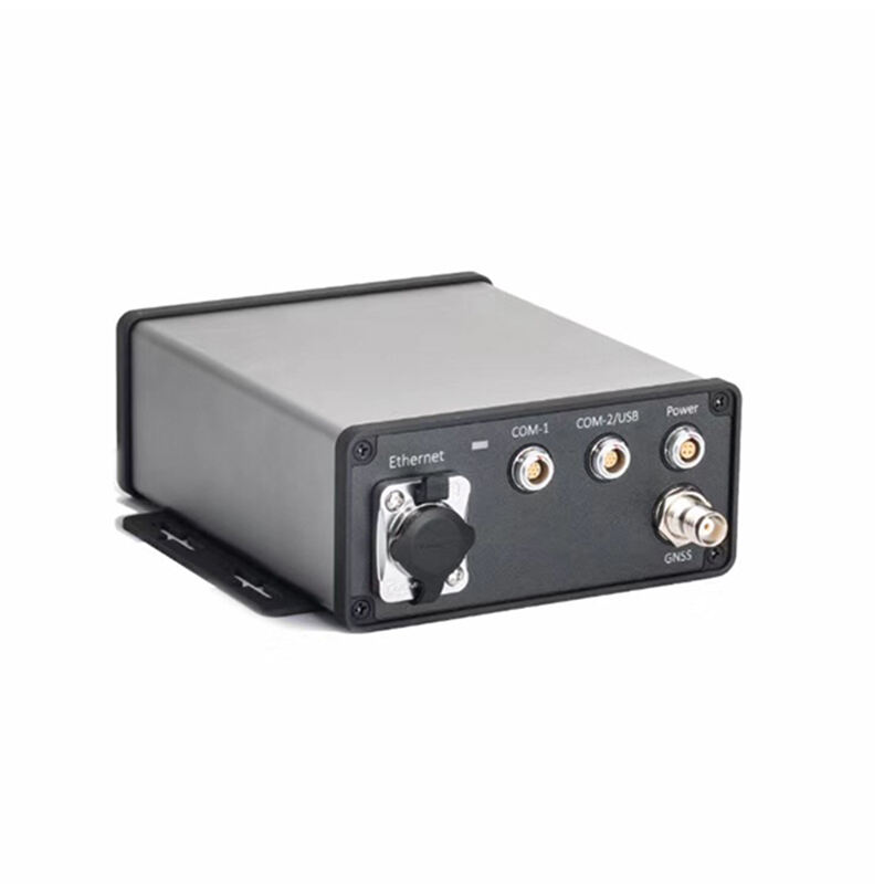
The surveying GNSS receiver incorporates professional-grade construction and rugged design elements specifically engineered to withstand the demanding conditions encountered in professional surveying environments, ensuring reliable operation and long-term durability across diverse field applications. These devices feature reinforced housings constructed from high-impact materials that resist damage from drops, vibrations, and rough handling typical of construction and surveying activities. The surveying GNSS receiver meets stringent military and industrial standards for shock resistance, typically withstanding drops from heights of 1.5 to 2 meters onto concrete surfaces without compromising functionality or accuracy performance. Advanced sealing technologies provide comprehensive protection against dust, moisture, and water ingress, with most professional models achieving IP67 or IP68 ratings that enable submersion in water up to one meter depth for extended periods. Temperature compensation systems ensure accurate operation across extreme temperature ranges, typically from -40°C to +65°C, allowing surveyors to work confidently in arctic conditions, desert environments, or tropical climates without concern for equipment failure or performance degradation. The surveying GNSS receiver incorporates corrosion-resistant materials and protective coatings that prevent deterioration from exposure to saltwater, chemicals, or harsh atmospheric conditions commonly encountered in marine, industrial, or mining surveying applications. Extended battery life capabilities, often exceeding 10-12 hours of continuous operation, eliminate concerns about power limitations during long surveying sessions or remote fieldwork where charging opportunities may be limited. The ergonomic design considerations include comfortable grips, intuitive control layouts, and sunlight-readable displays that maintain visibility and usability throughout extended field operations. Professional accessories and mounting options provide versatile configuration possibilities, allowing the surveying GNSS receiver to integrate seamlessly with tripods, poles, vehicles, or backpack systems depending on specific project requirements. Quality manufacturing processes and comprehensive testing procedures ensure each surveying GNSS receiver meets strict performance standards before deployment, while extensive warranty coverage and professional support services provide peace of mind for surveying professionals investing in these critical measurement tools.

Get a Free Quote

Our representative will contact you soon.
Email
Name
Company Name
Message
0/1000