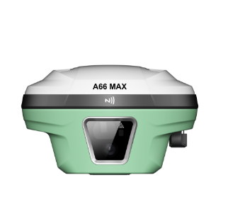
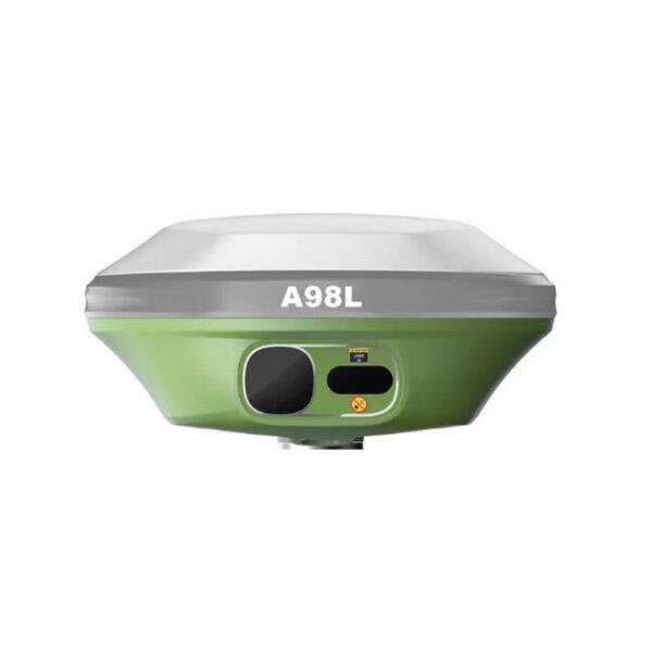
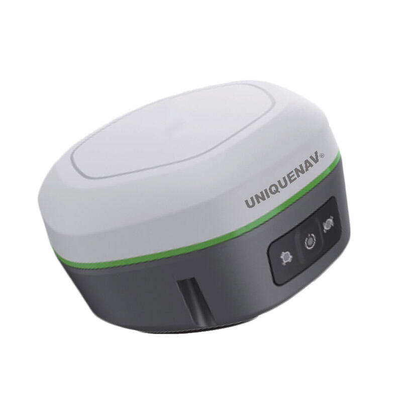
Affordable RTK GPS Systems: Professional Precision Positioning Technology for Modern Surveying

All Categories

affordable rtk gps

The affordable RTK GPS represents a revolutionary advancement in precision positioning technology, making high-accuracy surveying and navigation accessible to professionals across various industries. RTK, which stands for Real-Time Kinematic, is a satellite navigation technique that provides centimeter-level accuracy by using carrier-based ranging and a reference station to correct GPS signals in real-time. This affordable RTK GPS system delivers professional-grade positioning capabilities at a fraction of the traditional cost, democratizing access to precision measurement technology. The core functionality of an affordable RTK GPS centers on its ability to receive corrections from either a local base station or network RTK services, enabling positioning accuracy typically within 1-3 centimeters horizontally and 2-5 centimeters vertically. The system operates by establishing communication between a rover unit and a reference station, where the base station calculates positioning errors and transmits correction data to the mobile receiver. Modern affordable RTK GPS units feature multi-constellation support, simultaneously tracking GPS, GLONASS, Galileo, and BeiDou satellites to ensure maximum satellite availability and positioning reliability even in challenging environments. The technological features include advanced signal processing algorithms, integrated cellular or radio communication modules, and user-friendly interfaces that simplify complex surveying tasks. These systems typically support various correction formats including RTCM standards and can connect through multiple communication methods such as cellular networks, radio links, or internet connections. Applications for affordable RTK GPS span numerous industries including construction, agriculture, surveying, mapping, mining, and environmental monitoring. In construction, these systems enable precise grade checking, stake-out operations, and as-built surveys. Agricultural applications include precision planting, crop monitoring, and field mapping for variable rate applications. Land surveyors utilize affordable RTK GPS for boundary surveys, topographic mapping, and legal descriptions. The versatility and cost-effectiveness of modern affordable RTK GPS systems have transformed how professionals approach precision positioning tasks, making advanced surveying capabilities accessible to smaller firms and individual contractors who previously could not justify the investment in high-end surveying equipment.

New Product Recommendations

The affordable RTK GPS delivers substantial cost savings compared to traditional surveying equipment while maintaining professional-grade accuracy standards that meet industry requirements. Organizations can reduce their equipment investment by up to 70% compared to conventional total stations and high-end survey-grade GPS systems, enabling smaller companies to compete effectively in markets that previously required significant capital investment. The operational efficiency gains from affordable RTK GPS implementation are immediately measurable, with field crews completing surveying tasks in approximately half the time required by traditional methods. Teams can establish precise points, conduct topographic surveys, and perform layout work with significantly reduced setup time and minimal crew requirements. The learning curve for affordable RTK GPS operation is substantially shorter than traditional surveying methods, allowing new technicians to become productive within days rather than months of training. Modern affordable RTK GPS systems feature intuitive interfaces that guide users through complex procedures, eliminating much of the technical expertise traditionally required for precision surveying. The portability advantage of affordable RTK GPS systems enables rapid deployment across multiple job sites, with most units weighing less than 2 kilograms and featuring battery life exceeding 8 hours of continuous operation. This mobility allows survey crews to increase their daily productivity by moving efficiently between locations without the logistical challenges associated with heavy surveying instruments. Data integration capabilities of affordable RTK GPS systems streamline project workflows by directly exporting measurements to CAD software, GIS applications, and construction management platforms. This seamless data flow eliminates manual transcription errors and reduces the time between field measurement and final deliverables. The reliability of modern affordable RTK GPS systems has improved dramatically, with many units featuring IP67 weatherproofing, shock-resistant construction, and redundant communication systems that ensure consistent performance in harsh field conditions. Maintenance requirements are minimal compared to mechanical surveying instruments, with most affordable RTK GPS units requiring only periodic software updates and basic cleaning procedures. The scalability of affordable RTK GPS systems allows organizations to start with basic configurations and expand capabilities as project requirements grow, providing a flexible investment path that adapts to changing business needs. Technical support and training resources for affordable RTK GPS systems have become increasingly comprehensive, with manufacturers offering online tutorials, regional training programs, and responsive technical assistance that ensures users maximize their equipment investment. The return on investment for affordable RTK GPS systems typically occurs within 6-12 months of implementation, considering the combined benefits of reduced equipment costs, improved productivity, and decreased labor requirements.

Practical Tips

GNSS RTK vs. Traditional Surveying: What’s the Difference?

27

Nov

GNSS RTK vs. Traditional Surveying: What’s the Difference?

Modern surveying has undergone a revolutionary transformation with the introduction of Global Navigation Satellite Systems (GNSS) technology, particularly Real-Time Kinematic (RTK) positioning. While traditional surveying methods have served the cons...
View More
How Can RTK Improve Surveying Precision for Large Construction Sites?

22

Dec

How Can RTK Improve Surveying Precision for Large Construction Sites?

Modern construction projects demand unprecedented accuracy and efficiency, particularly when dealing with expansive development sites spanning hundreds of acres. Traditional surveying methods often fall short when faced with the complexities of large...
View More
Why Do Mapping Teams Prefer RTK for Real-Time Positioning Tasks?

22

Dec

Why Do Mapping Teams Prefer RTK for Real-Time Positioning Tasks?

Modern mapping teams face unprecedented demands for precision and speed in their surveying operations. The evolution of positioning technologies has revolutionized how professionals approach field data collection, with RTK for real-time positioning e...
View More
What Should Buyers Compare When Sourcing RTK GPS Equipment?

13

Jan

What Should Buyers Compare When Sourcing RTK GPS Equipment?

Modern construction, surveying, and agricultural operations increasingly rely on precise positioning technology to achieve millimeter-level accuracy in their work. When sourcing RTK GPS equipment, buyers face numerous technical specifications, featur...
View More

Get a Free Quote

Our representative will contact you soon.
Email
Name
Company Name
Message
0/1000

affordable rtk gps

Centimeter-Level Accuracy at Unprecedented Value

Centimeter-Level Accuracy at Unprecedented Value

The most compelling feature of affordable RTK GPS technology lies in its ability to deliver centimeter-level positioning accuracy that rivals systems costing significantly more, making precision surveying accessible to organizations with limited budgets. This accuracy achievement represents a fundamental shift in surveying economics, where professional-grade results no longer require premium equipment investments. The affordable RTK GPS maintains horizontal accuracy within 1-3 centimeters and vertical accuracy within 2-5 centimeters under optimal conditions, meeting or exceeding the precision requirements for most construction, surveying, and mapping applications. This level of accuracy is achieved through sophisticated signal processing algorithms that analyze carrier-phase measurements from multiple satellite constellations simultaneously, creating a robust positioning solution that performs consistently across various environmental conditions. The value proposition becomes particularly evident when comparing project completion times and accuracy standards with traditional surveying methods, where affordable RTK GPS systems often deliver superior results in significantly less time. Quality control procedures that previously required multiple measurement techniques can now be completed with a single instrument, reducing equipment needs and simplifying field operations. The accuracy consistency of affordable RTK GPS systems across different measurement scenarios provides confidence for critical applications such as construction layout, boundary surveys, and engineering projects where precision directly impacts project success. Advanced error modeling and atmospheric correction algorithms embedded in modern affordable RTK GPS receivers automatically compensate for signal delays and multipath interference, maintaining accuracy standards even in challenging environments such as urban areas with tall buildings or heavily wooded locations. The long-term accuracy stability of these systems ensures that measurements remain reliable throughout extended projects, with drift characteristics that meet professional surveying standards. Calibration procedures for affordable RTK GPS systems are streamlined and often automated, eliminating the complex adjustment procedures required by traditional surveying instruments while maintaining traceable accuracy standards. The accuracy validation features built into modern affordable RTK GPS systems provide real-time quality indicators that help operators identify optimal measurement conditions and potential sources of error, ensuring consistent results across different users and environmental conditions. This combination of high accuracy, ease of use, and affordable pricing has transformed the surveying industry by enabling precision measurement capabilities for applications and organizations that previously relied on less accurate or more expensive alternatives.
Multi-Constellation Satellite Support for Maximum Reliability

Multi-Constellation Satellite Support for Maximum Reliability

The multi-constellation capability of affordable RTK GPS systems represents a significant technological advancement that dramatically improves positioning reliability, availability, and performance compared to single-constellation receivers. Modern affordable RTK GPS units simultaneously track satellites from GPS, GLONASS, Galileo, and BeiDou constellations, providing access to over 100 satellites worldwide and ensuring optimal positioning geometry in virtually any location. This multi-constellation approach addresses one of the most significant limitations of traditional GPS systems by maintaining positioning capability in challenging environments where satellite visibility is restricted by buildings, terrain, or vegetation. The increased satellite availability translates directly into faster initialization times, with affordable RTK GPS systems typically achieving fixed solutions in 30-60 seconds compared to several minutes required by older single-constellation systems. Signal redundancy provided by multiple satellite constellations enhances positioning reliability by maintaining accuracy even when individual satellites are blocked or experiencing signal interference, ensuring continuous operation during critical surveying tasks. The geometric diversity of satellites from different constellations improves the mathematical strength of position calculations, resulting in more stable and accurate positioning solutions across various environmental conditions. Advanced signal processing algorithms in affordable RTK GPS receivers optimize constellation selection based on real-time signal quality assessment, automatically choosing the best combination of satellites to maximize positioning performance while minimizing potential error sources. The global coverage provided by multi-constellation support ensures consistent performance regardless of geographic location, making affordable RTK GPS systems suitable for international projects or operations in remote areas where traditional GPS coverage might be limited. Interference resistance is significantly enhanced through multi-constellation operation, as jamming or signal interference affecting one constellation can be compensated by continued operation on other satellite systems, maintaining positioning capability in electronically challenging environments. The future-proofing aspect of multi-constellation support ensures that affordable RTK GPS investments remain viable as new satellites are launched and constellation capabilities expand, protecting equipment investments against technological obsolescence. Quality control features leverage multi-constellation data to provide enhanced accuracy assessment and error detection capabilities, allowing operators to identify and correct potential measurement issues in real-time. The power efficiency of modern multi-constellation receivers has been optimized to maintain extended battery life despite processing signals from multiple satellite systems, ensuring full-day operation without compromising performance. This comprehensive satellite support system transforms affordable RTK GPS units into highly reliable positioning tools that perform consistently across diverse applications and environmental conditions, providing the dependability required for professional surveying and construction applications.
Seamless Integration and User-Friendly Operation

Seamless Integration and User-Friendly Operation

The integration capabilities and user-friendly design of affordable RTK GPS systems eliminate traditional barriers to precision surveying adoption, enabling organizations to implement advanced positioning technology without extensive training or workflow disruption. Modern affordable RTK GPS units feature intuitive touchscreen interfaces that guide users through complex surveying procedures with step-by-step instructions, reducing the learning curve and minimizing the potential for operator error. The software ecosystem surrounding affordable RTK GPS systems includes comprehensive field applications that handle everything from basic point collection to complex construction layout tasks, providing a complete surveying solution in a single integrated package. Data compatibility represents a crucial advantage, with affordable RTK GPS systems supporting industry-standard formats that ensure seamless integration with existing CAD software, GIS applications, and project management systems used across construction and surveying industries. Cloud connectivity features enable real-time data synchronization between field crews and office personnel, facilitating immediate quality control review and eliminating delays associated with traditional data transfer methods. The plug-and-play nature of modern affordable RTK GPS systems allows rapid deployment with minimal setup requirements, enabling crews to begin productive work within minutes of arriving at a job site rather than spending significant time on equipment configuration. Wireless communication capabilities built into affordable RTK GPS receivers support multiple connection methods including cellular networks, Wi-Fi, and Bluetooth, ensuring reliable data transmission across various field conditions and communication infrastructure limitations. The automated correction source management features of advanced affordable RTK GPS systems intelligently select optimal correction services based on location and accuracy requirements, removing technical complexity while ensuring maximum positioning performance. Training resources provided by affordable RTK GPS manufacturers typically include comprehensive online tutorials, video demonstrations, and interactive learning modules that enable users to develop proficiency quickly and cost-effectively. Technical support structures for affordable RTK GPS systems often exceed those available for traditional surveying equipment, with manufacturers providing responsive assistance through multiple channels including phone support, remote troubleshooting, and online resources. The modular design philosophy of many affordable RTK GPS systems allows users to start with basic configurations and add capabilities as needs evolve, providing a scalable investment path that grows with organizational requirements. Firmware update capabilities ensure that affordable RTK GPS systems continue to improve over time, with manufacturers regularly releasing enhancements that add new features and improve performance without requiring hardware replacement. The standardized operation procedures across different affordable RTK GPS models facilitate crew training and equipment interchangeability, reducing operational complexity for organizations managing multiple units or planning equipment upgrades.

Get a Free Quote

Our representative will contact you soon.
Email
Name
Company Name
Message
0/1000