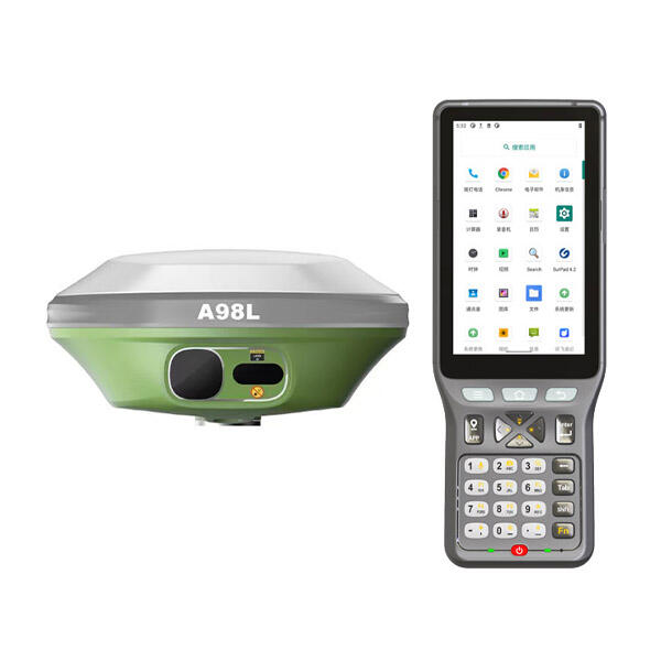
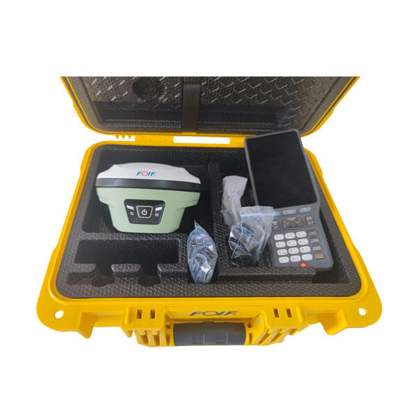
Professional GNSS Base and Rover Systems - Precision Surveying Technology Solutions

All Categories

gnss base and rover

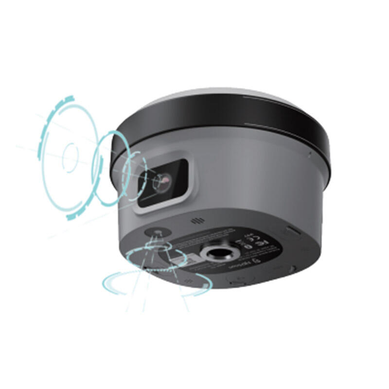
A GNSS base and rover system represents cutting-edge positioning technology that delivers centimeter-level accuracy for professional surveying, construction, and mapping applications. This dual-component solution consists of a stationary base station and a mobile rover unit that work together to provide Real-Time Kinematic (RTK) corrections for precise positioning measurements. The base station establishes a fixed reference point with known coordinates, continuously receiving signals from multiple satellite constellations including GPS, GLONASS, Galileo, and BeiDou. Meanwhile, the rover unit moves freely across the survey area, receiving both satellite signals and correction data from the base station to calculate its exact position with remarkable precision. The GNSS base and rover configuration eliminates common positioning errors caused by atmospheric interference, satellite clock drift, and orbital uncertainties. The base station monitors these error sources in real-time and transmits correction data to the rover through radio communication or cellular networks. This correction process enables the rover to achieve positioning accuracy within 1-2 centimeters horizontally and 2-3 centimeters vertically under optimal conditions. Modern GNSS base and rover systems feature advanced signal processing capabilities, supporting multi-frequency reception and anti-jamming technology. The equipment typically includes integrated displays, data logging capabilities, and wireless communication modules for seamless operation. Users can configure survey points, establish coordinate systems, and export measurement data directly from the field. The system's versatility extends across numerous professional applications including land surveying, construction layout, topographic mapping, infrastructure monitoring, precision agriculture, and geospatial data collection. Professional surveyors rely on GNSS base and rover technology for boundary surveys, subdivision layouts, and legal property documentation requiring certified accuracy standards.

New Product Recommendations

The GNSS base and rover system delivers exceptional value through its superior accuracy and efficiency compared to traditional surveying methods. Users achieve centimeter-level precision consistently across large survey areas without the time-consuming processes associated with conventional total stations or tape measurements. This precision translates directly into reduced project costs and eliminated rework scenarios that often plague construction and surveying projects. The system dramatically increases productivity by enabling single-person operation where traditional methods required multiple team members. Surveyors complete boundary surveys, topographic mapping, and construction stakeout projects in significantly less time while maintaining professional accuracy standards. The mobility advantage of the rover unit allows operators to access challenging terrain and remote locations that would be difficult or impossible to reach with traditional surveying equipment. Weather resistance and rugged construction ensure reliable performance in harsh environmental conditions including rain, dust, and extreme temperatures. The GNSS base and rover setup eliminates line-of-sight requirements between measurement points, a major limitation of conventional surveying instruments. This freedom enables efficient data collection across varied topography including forests, urban environments, and construction sites with numerous obstructions. Real-time data processing capabilities provide immediate feedback on measurement quality and accuracy, allowing operators to verify results in the field before moving to subsequent locations. The system's compatibility with industry-standard software platforms streamlines data integration with CAD programs, GIS applications, and project management systems. Cost-effectiveness becomes apparent through reduced labor requirements, faster project completion times, and minimized equipment transportation needs. The technology scales efficiently from small residential surveys to large infrastructure projects without requiring different equipment configurations. Long-term reliability and low maintenance requirements further enhance the total cost of ownership while ensuring consistent performance across thousands of measurement cycles. The GNSS base and rover combination provides professional surveyors with a competitive advantage through enhanced service delivery capabilities and the ability to handle more complex projects efficiently.

Tips And Tricks

Choosing the Best GNSS RTK System for Your Project

27

Nov

Choosing the Best GNSS RTK System for Your Project

When precision positioning is critical for your surveying, construction, or engineering project, selecting the right GNSS RTK system becomes a pivotal decision that can determine project success. Modern surveying demands centimeter-level accuracy, re...
View More
Why Do Mapping Teams Prefer RTK for Real-Time Positioning Tasks?

22

Dec

Why Do Mapping Teams Prefer RTK for Real-Time Positioning Tasks?

Modern mapping teams face unprecedented demands for precision and speed in their surveying operations. The evolution of positioning technologies has revolutionized how professionals approach field data collection, with RTK for real-time positioning e...
View More
How Can a Digital Level Boost Efficiency in Surveying Tasks?

11

Feb

How Can a Digital Level Boost Efficiency in Surveying Tasks?

Modern surveying operations demand precision, speed, and reliability to meet tight project deadlines while maintaining accuracy standards. Traditional surveying methods, while foundational, often fall short of the efficiency requirements in today's f...
View More
Why Are Digital Levels Preferred Over Traditional Bubble Levels?

11

Feb

Why Are Digital Levels Preferred Over Traditional Bubble Levels?

The construction and engineering industries have witnessed a significant transformation in measurement tools over the past decade. Among these advancements, digital levels have emerged as the preferred choice for professionals who demand precision, e...
View More

Get a Free Quote

Our representative will contact you soon.
Email
Name
Company Name
Message
0/1000

gnss base and rover

Unmatched Precision and Reliability for Professional Applications

Unmatched Precision and Reliability for Professional Applications

The GNSS base and rover system stands out in the surveying industry through its exceptional precision capabilities that consistently deliver centimeter-level accuracy across diverse field conditions. This remarkable precision stems from the sophisticated RTK correction methodology where the base station continuously monitors satellite signal errors and transmits real-time corrections to the rover unit. The technology eliminates atmospheric delays, satellite clock errors, and orbital uncertainties that typically compromise positioning accuracy in standalone GPS devices. Professional surveyors depend on this reliability for legal boundary determinations, construction layout projects, and infrastructure development where measurement errors can result in costly disputes and project delays. The system maintains its precision performance across extended baseline distances, typically operating effectively within a 10-15 kilometer radius from the base station. This extended range capability enables coverage of large survey areas with a single base station setup, reducing equipment requirements and operational complexity. The multi-constellation satellite support enhances signal availability and geometric diversity, ensuring consistent performance even in challenging environments with partial sky obstruction. Advanced signal processing algorithms automatically detect and reject multipath signals that could compromise accuracy, while adaptive filtering techniques optimize position solutions based on current satellite geometry and signal quality conditions. The GNSS base and rover configuration provides measurement repeatability within millimeter ranges, enabling precise monitoring applications for structural deformation, ground subsidence, and other dynamic phenomena requiring high-precision change detection. Quality assurance features include real-time accuracy indicators, data logging capabilities, and automatic error detection systems that alert operators to potential measurement issues before they impact survey results. This combination of precision, reliability, and quality assurance makes the GNSS base and rover system indispensable for professional applications where accuracy requirements exceed the capabilities of traditional surveying methods or standard positioning devices.
Enhanced Productivity Through Advanced Technology Integration

Enhanced Productivity Through Advanced Technology Integration

Modern GNSS base and rover systems revolutionize surveying productivity through seamless integration of advanced technologies that streamline field operations and data management processes. The wireless communication capabilities enable real-time data transmission between base and rover units, eliminating the need for physical data collection visits and reducing survey completion times significantly. Integrated cellular modems allow connection to NTRIP correction services, providing RTK corrections without deploying a dedicated base station for smaller projects or urban areas with existing reference networks. The user interface design prioritizes operational efficiency with intuitive touchscreen displays, customizable measurement workflows, and automated data validation routines that minimize operator training requirements and reduce the potential for human errors. Cloud-based data synchronization ensures immediate availability of survey results across project teams, enabling real-time collaboration between field crews, office personnel, and clients. The system's compatibility with popular surveying software platforms eliminates data conversion steps and integrates seamlessly with existing project workflows. Advanced stakeout capabilities guide operators directly to predetermined points using visual and audio indicators, significantly reducing the time required for construction layout and boundary marking activities. The GNSS base and rover technology supports multiple coordinate systems and datum transformations, allowing operators to work directly in project-specific coordinate frameworks without manual conversion processes. Automated quality control features continuously monitor measurement conditions and provide real-time feedback on position accuracy, satellite availability, and correction data status. These productivity enhancements translate into measurable business benefits including reduced project timelines, lower labor costs, and increased capacity to handle multiple concurrent projects. The technology enables single-person survey operations where traditional methods required multi-person crews, maximizing resource utilization and project profitability. Long battery life and efficient power management extend field operation time while rapid startup procedures minimize setup delays between measurement locations.
Versatile Applications Across Multiple Industries

Versatile Applications Across Multiple Industries

The adaptability of GNSS base and rover systems makes them invaluable across numerous industries and applications, from traditional land surveying to emerging precision agriculture and autonomous vehicle guidance systems. In construction applications, the technology enables accurate building layout, grade control for earthmoving equipment, and infrastructure monitoring throughout project lifecycles. Contractors rely on GNSS base and rover precision for foundation placement, utility installation, and quality control measurements that ensure compliance with engineering specifications and building codes. Agricultural professionals utilize the technology for precision farming applications including field mapping, crop monitoring, and automated machinery guidance systems that optimize planting patterns and resource utilization. The system's real-time positioning capabilities support variable rate application of fertilizers and pesticides, reducing input costs while maximizing crop yields through data-driven farming practices. Environmental monitoring projects benefit from the precise positioning required for groundwater monitoring well installation, wetland delineation, and ecological habitat mapping where accurate geographic data supports regulatory compliance and conservation efforts. Mining and quarry operations depend on GNSS base and rover technology for ore body mapping, haul road design, and equipment guidance systems that improve operational efficiency and safety standards. The technology supports cadastral surveying requirements for property boundary determination, subdivision development, and legal documentation where positioning accuracy directly impacts property values and ownership rights. Transportation infrastructure projects utilize GNSS positioning for highway design, bridge construction monitoring, and railway alignment surveys that require millimeter-level precision over extended distances. Emergency response applications include disaster mapping, search and rescue operations, and infrastructure damage assessment where rapid deployment and accurate positioning capabilities support critical decision-making processes. The flexibility to operate in diverse environments from dense urban areas to remote wilderness locations makes GNSS base and rover systems essential tools for geospatial professionals across multiple industry sectors requiring reliable positioning solutions.

Get a Free Quote

Our representative will contact you soon.
Email
Name
Company Name
Message
0/1000