Professional RTK Modules: Centimeter-Level Precision Positioning Solutions

All Categories

rtk modules

RTK modules represent a revolutionary advancement in precision positioning technology, offering centimeter-level accuracy for a wide range of applications. Real Time Kinematic positioning systems utilize satellite navigation signals to provide precise location data with remarkable accuracy, typically achieving positioning precision within 1-2 centimeters. These sophisticated rtk modules incorporate advanced signal processing capabilities, enabling users to obtain high-precision coordinates in real-time applications. The core functionality of rtk modules revolves around processing differential corrections from reference stations, which significantly enhance the accuracy of standard GNSS positioning. Modern rtk modules support multiple constellation systems including GPS, GLONASS, Galileo, and BeiDou, ensuring robust performance across different geographical regions and environmental conditions. The technological foundation of these systems relies on carrier phase measurements and sophisticated algorithms that resolve integer ambiguities in satellite signals. RTK modules feature compact designs that integrate seamlessly into various devices and equipment, making them ideal for surveying instruments, agricultural machinery, construction equipment, and autonomous vehicles. These modules typically include built-in communication interfaces such as radio modems, cellular connectivity, or Wi-Fi capabilities, facilitating the transmission of correction data between base stations and rovers. The processing power of contemporary rtk modules enables rapid initialization times, often achieving fixed solutions within seconds of startup. Advanced rtk modules incorporate robust error correction mechanisms and quality assurance protocols that ensure reliable performance even in challenging environments with signal obstructions or interference. The versatility of these positioning systems extends to both static and kinematic applications, supporting professional surveyors, precision agriculture specialists, construction professionals, and researchers who require accurate spatial data collection and navigation capabilities.

New Product Recommendations

RTK modules deliver exceptional positioning accuracy that transforms how professionals approach location-based tasks and measurements. Users experience significant time savings compared to traditional surveying methods, as rtk modules eliminate the need for multiple measurement sessions and complex post-processing procedures. The real-time nature of these systems allows operators to verify measurements instantly, reducing errors and improving workflow efficiency. Modern rtk modules offer remarkable cost-effectiveness by combining multiple positioning technologies into a single, integrated solution that reduces equipment expenses and operational overhead. These systems provide consistent performance across various environmental conditions, ensuring reliable results whether working in urban areas with tall buildings, forested regions, or open agricultural fields. The plug-and-play design of contemporary rtk modules simplifies implementation, allowing users to integrate precise positioning capabilities into existing equipment without extensive modifications or specialized training. Battery life optimization in modern rtk modules ensures extended field operation, with many systems providing full-day performance on a single charge. The flexibility of these modules supports both professional and commercial applications, making precision positioning accessible to small businesses and individual operators. RTK modules enhance safety by providing accurate navigation data for heavy machinery operators, reducing the risk of accidents and improving operational awareness. The scalability of these systems allows organizations to start with basic configurations and expand capabilities as requirements grow. Data logging capabilities built into rtk modules enable comprehensive record-keeping and analysis, supporting quality control processes and regulatory compliance requirements. Integration compatibility ensures rtk modules work seamlessly with existing software platforms and equipment systems, minimizing disruption to established workflows. The durability and weather resistance of industrial-grade rtk modules guarantee reliable performance in harsh outdoor conditions, protecting investments and ensuring consistent operation. Remote monitoring capabilities allow supervisors to track equipment location and performance metrics, improving project management and resource allocation. The global compatibility of multi-constellation rtk modules ensures consistent performance regardless of geographical location, making these systems ideal for international operations and traveling professionals.

Latest News

How GNSS RTK Systems Deliver High-Precision Results

27

Nov

How GNSS RTK Systems Deliver High-Precision Results

Modern surveying and positioning applications demand exceptional accuracy that traditional GPS systems simply cannot deliver. Global Navigation Satellite System Real-Time Kinematic (GNSS RTK Systems) have revolutionized precision positioning by provi...
View More
Why Do Mapping Teams Prefer RTK for Real-Time Positioning Tasks?

22

Dec

Why Do Mapping Teams Prefer RTK for Real-Time Positioning Tasks?

Modern mapping teams face unprecedented demands for precision and speed in their surveying operations. The evolution of positioning technologies has revolutionized how professionals approach field data collection, with RTK for real-time positioning e...
View More
How Do Total Stations Support High-Accuracy Layout in Construction?

13

Jan

How Do Total Stations Support High-Accuracy Layout in Construction?

Construction projects demand exceptional precision when establishing accurate layout points and measurements across job sites. Modern surveying instruments have revolutionized how construction professionals approach dimensional control and spatial po...
View More
How Does a Digital Level Improve Accuracy in Construction Measurements?

13

Jan

How Does a Digital Level Improve Accuracy in Construction Measurements?

Construction professionals understand that precision forms the foundation of every successful project. Modern building techniques demand measurement accuracy that surpasses traditional methods, making the digital level an indispensable tool for contr...
View More

Get a Free Quote

Our representative will contact you soon.
Email
Name
Company Name
Message
0/1000

rtk modules

Centimeter-Level Precision for Professional Applications

Centimeter-Level Precision for Professional Applications

RTK modules revolutionize precision positioning by delivering centimeter-level accuracy that meets the demanding requirements of professional surveying, construction, and engineering applications. This exceptional precision capability transforms traditional measurement approaches, enabling users to achieve survey-grade accuracy without the complexity and expense of conventional surveying equipment. The advanced signal processing algorithms embedded in rtk modules analyze carrier phase measurements from multiple satellite constellations, resolving ambiguities in real-time to deliver consistent 1-2 centimeter accuracy under optimal conditions. This level of precision proves invaluable for construction site layout, where accurate positioning ensures structural elements align perfectly according to architectural plans and engineering specifications. Professional surveyors benefit enormously from the real-time nature of rtk modules, as they can verify boundary markers, establish property lines, and conduct topographic surveys with confidence in the accuracy of their measurements. The precision capabilities extend to agricultural applications, where rtk modules enable variable rate application of fertilizers and pesticides, optimizing crop yields while minimizing environmental impact through precise field mapping and guidance systems. Engineering projects requiring precise elevation data rely on rtk modules to establish accurate vertical references, ensuring proper drainage gradients and structural foundations meet design specifications. The consistent accuracy of these systems reduces the need for redundant measurements and verification surveys, significantly improving project timelines and reducing operational costs. Quality assurance protocols built into rtk modules provide confidence indicators and error estimates, allowing operators to assess measurement reliability and make informed decisions about data quality. The precision capabilities of rtk modules support advanced applications such as machine control systems, where construction equipment follows precise three-dimensional models to achieve exact grading and excavation results. This level of accuracy enables innovative construction techniques and supports the growing adoption of Building Information Modeling in construction projects.
Multi-Constellation Support for Enhanced Reliability

Multi-Constellation Support for Enhanced Reliability

Modern rtk modules incorporate multi-constellation support that dramatically enhances positioning reliability and performance consistency across diverse operational environments and geographical locations. This comprehensive satellite system compatibility ensures rtk modules maintain robust signal reception and accurate positioning even when individual constellation signals experience interference or degradation. The integration of GPS, GLONASS, Galileo, and BeiDou satellite systems provides rtk modules with access to over 100 satellites simultaneously, creating redundancy that ensures continuous operation in challenging environments such as urban canyons, dense forests, or mountainous terrain. This multi-constellation approach significantly reduces the time required for initial positioning fixes, often achieving centimeter-level accuracy within seconds of startup compared to single-constellation systems that may require several minutes for reliable positioning. The global coverage provided by multiple satellite constellations ensures rtk modules perform consistently regardless of geographical location, making these systems ideal for international projects and organizations operating across multiple continents. Enhanced satellite geometry resulting from multi-constellation support improves dilution of precision values, leading to more accurate and stable positioning solutions throughout the day. The redundancy provided by multiple satellite systems enhances system resilience against signal jamming or spoofing attempts, ensuring continued operation in security-sensitive applications. RTK modules with multi-constellation support demonstrate superior performance in polar regions and equatorial zones where single constellation systems may experience coverage limitations. The increased satellite availability enables more frequent measurement updates, supporting dynamic applications such as precision agriculture guidance systems and autonomous vehicle navigation. Advanced rtk modules intelligently select optimal satellite combinations from available constellations, automatically adapting to changing signal conditions and maintaining peak performance without user intervention. This intelligent constellation management extends battery life by optimizing power consumption while maintaining positioning accuracy requirements. The future-proof design of multi-constellation rtk modules ensures compatibility with emerging satellite systems and signal improvements, protecting investment value and extending operational lifespan.
Seamless Integration and Communication Capabilities

Seamless Integration and Communication Capabilities

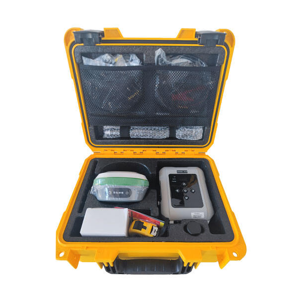
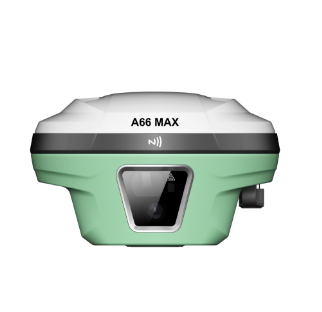
RTK modules excel in their sophisticated integration and communication capabilities, offering versatile connectivity options that seamlessly interface with existing equipment and software systems across diverse industrial applications. These advanced communication features eliminate traditional barriers to precision positioning implementation, enabling organizations to upgrade their operational capabilities without extensive system overhauls or specialized infrastructure investments. Modern rtk modules incorporate multiple communication protocols including radio modems, cellular networks, Wi-Fi, and Bluetooth connectivity, providing flexible options for transmitting correction data between base stations and rover units across varying operational scales and environmental conditions. The plug-and-play architecture of contemporary rtk modules supports standard industry interfaces such as RS-232, USB, and Ethernet connections, ensuring compatibility with surveying instruments, agricultural equipment, construction machinery, and mobile computing devices. Advanced rtk modules feature intelligent communication management that automatically selects optimal data transmission methods based on signal strength, distance requirements, and power consumption considerations, ensuring reliable operation without constant user intervention. The standardized output formats supported by rtk modules, including NMEA sentences and industry-specific protocols, enable direct integration with Geographic Information Systems, Computer-Aided Design software, and enterprise resource planning platforms. Cloud-based correction services supported by modern rtk modules eliminate the need for local base station infrastructure, reducing setup complexity and operational costs while maintaining high accuracy standards through network RTK services. The bidirectional communication capabilities of advanced rtk modules enable remote configuration, firmware updates, and diagnostic monitoring, supporting proactive maintenance and reducing downtime in mission-critical applications. These systems support simultaneous multi-user access, allowing multiple operators to share correction data from a single base station, maximizing equipment utilization and reducing per-user costs in large-scale operations. The robust error correction and data validation protocols embedded in rtk modules ensure communication integrity even in noisy electromagnetic environments, maintaining positioning accuracy and system reliability. Integration APIs and software development kits provided with rtk modules enable custom application development, allowing organizations to create specialized solutions that meet unique operational requirements while leveraging proven positioning technology.

Get a Free Quote

Our representative will contact you soon.
Email
Name
Company Name
Message
0/1000