Professional Global Navigation Satellite System Receivers - High-Precision GNSS Solutions for Surveying and Mapping

All Categories

global navigation satellite system receiver

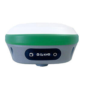
A global navigation satellite system receiver represents a sophisticated electronic device that captures and processes signals transmitted from satellite constellations orbiting Earth to determine precise positioning, velocity, and timing information. These advanced receivers utilize multiple satellite systems including GPS (Global Positioning System), GLONASS (Global Navigation Satellite System), Galileo, and BeiDou to deliver accurate location data across various applications. The primary function of a global navigation satellite system receiver involves receiving radio frequency signals from multiple satellites simultaneously, calculating distances through time-of-flight measurements, and employing trilateration algorithms to establish exact geographical coordinates. Modern global navigation satellite system receivers incorporate multi-constellation capability, enabling them to access signals from different satellite networks for enhanced accuracy and reliability. These devices feature robust signal processing capabilities, advanced antenna designs, and sophisticated chipsets that can handle weak signals in challenging environments such as urban canyons or dense forest coverage. The technological architecture includes radio frequency front-ends that amplify and filter incoming satellite signals, digital signal processors that decode navigation messages, and embedded processors that execute positioning calculations. Contemporary global navigation satellite system receivers support various augmentation systems like WAAS, EGNOS, and MSAS to achieve sub-meter accuracy levels. They incorporate advanced features such as Real-Time Kinematic processing, Precise Point Positioning, and multi-frequency signal reception. The operational frequency bands typically include L1, L2, and L5 frequencies, with newer models supporting emerging L6 signals. These receivers find extensive applications across surveying and mapping industries, precision agriculture, autonomous vehicle navigation, marine and aviation sectors, construction and mining operations, emergency services, and consumer electronics including smartphones and wearable devices.

New Product Recommendations

The global navigation satellite system receiver offers numerous compelling advantages that make it an essential tool for professionals and consumers seeking reliable positioning solutions. First and foremost, these receivers provide exceptional accuracy levels that surpass traditional navigation methods, delivering positioning precision within centimeters when using advanced techniques like RTK processing. This remarkable accuracy translates into significant cost savings for surveying projects, construction activities, and precision agriculture applications where exact measurements are crucial. The multi-constellation support feature ensures reliable performance even in challenging environments where satellite visibility might be limited, as the global navigation satellite system receiver can simultaneously track signals from GPS, GLONASS, Galileo, and BeiDou systems. This redundancy dramatically improves service availability and reduces the likelihood of signal loss in urban areas or mountainous terrain. Users benefit from faster acquisition times and improved signal tracking capabilities, resulting in quicker startup procedures and more consistent performance throughout operation periods. The versatility of modern global navigation satellite system receivers allows them to serve multiple industries and applications, from high-precision surveying to recreational outdoor activities, making them valuable investments for diverse user groups. Energy efficiency represents another significant advantage, as contemporary receivers consume minimal power while maintaining continuous operation, extending battery life for portable applications. The robust construction and weatherproof designs ensure reliable performance in harsh environmental conditions, including extreme temperatures, humidity, and vibration exposure. Integration capabilities allow seamless connection with various external devices, sensors, and software platforms, enhancing workflow efficiency and data management processes. Real-time data processing capabilities enable immediate decision-making and eliminate delays associated with post-processing procedures. The user-friendly interfaces and intuitive operation procedures make these devices accessible to operators with varying technical expertise levels. Advanced global navigation satellite system receivers also provide comprehensive data logging capabilities, storing positioning information, measurement parameters, and system status for later analysis and quality assurance purposes. The scalability of these systems allows users to upgrade functionality through software updates and additional modules, protecting their investment while adapting to evolving requirements.

Latest News

Top Tips for Using High Accuracy Handheld GPS in the Field

27

Nov

Top Tips for Using High Accuracy Handheld GPS in the Field

Professional fieldwork demands precision, reliability, and efficiency in positioning technology. Modern surveying, construction, and geospatial applications require positioning solutions that deliver centimeter-level accuracy while maintaining the po...
View More
How Do RTK GNSS Receivers Maintain Stability in Complex Terrains?

22

Dec

How Do RTK GNSS Receivers Maintain Stability in Complex Terrains?

Navigation accuracy in challenging environments has become a critical requirement across industries ranging from construction and surveying to autonomous vehicles and precision agriculture. RTK GNSS receivers represent the pinnacle of satellite-based...
View More
How Do Total Stations Support High-Accuracy Layout in Construction?

13

Jan

How Do Total Stations Support High-Accuracy Layout in Construction?

Construction projects demand exceptional precision when establishing accurate layout points and measurements across job sites. Modern surveying instruments have revolutionized how construction professionals approach dimensional control and spatial po...
View More
What Key Features Should You Check When Buying an Auto Level?

11

Feb

What Key Features Should You Check When Buying an Auto Level?

When precision matters most in construction and surveying projects, selecting the right auto level becomes a critical decision that can impact the success of your entire operation. An auto level serves as the backbone of accurate height measurements ...
View More

Get a Free Quote

Our representative will contact you soon.
Email
Name
Company Name
Message
0/1000

global navigation satellite system receiver

Multi-Constellation Technology for Unmatched Reliability

Multi-Constellation Technology for Unmatched Reliability

The revolutionary multi-constellation technology incorporated in advanced global navigation satellite system receivers represents a quantum leap in positioning reliability and accuracy. This sophisticated feature enables simultaneous reception and processing of signals from multiple satellite networks including American GPS, Russian GLONASS, European Galileo, and Chinese BeiDou systems, creating an unprecedented level of redundancy and performance enhancement. When a global navigation satellite system receiver utilizes multi-constellation technology, it dramatically increases the number of available satellites from which it can receive signals, often doubling or tripling the satellite count compared to single-system receivers. This abundance of satellite signals provides several critical benefits that directly impact user experience and operational success. Enhanced signal availability ensures consistent positioning even in challenging environments where buildings, trees, or terrain might obstruct signals from certain satellites. The increased satellite diversity also improves geometric dilution of precision, resulting in more accurate position calculations and reduced measurement uncertainties. Users operating in urban environments particularly benefit from this technology, as the receiver can maintain reliable positioning even when tall buildings block significant portions of the sky. The multi-constellation capability also provides superior performance in high-latitude regions where traditional GPS coverage might be limited, ensuring global operational capability. This technology significantly reduces convergence time for precise positioning applications, allowing users to achieve centimeter-level accuracy more quickly than ever before. The redundancy offered by multiple constellation support also enhances system integrity, as the receiver can detect and exclude faulty satellite signals while maintaining accurate positioning through alternative satellites. Professional surveyors, construction professionals, and precision agriculture specialists particularly value this reliability enhancement, as it directly translates to improved productivity and reduced project delays. The multi-constellation global navigation satellite system receiver also demonstrates exceptional performance in kinematic applications, maintaining continuous positioning solutions even during rapid movement or temporary signal obstructions.
Real-Time Kinematic Processing for Centimeter-Level Accuracy

Real-Time Kinematic Processing for Centimeter-Level Accuracy

Real-Time Kinematic processing capabilities integrated into professional-grade global navigation satellite system receivers deliver unprecedented positioning accuracy that revolutionizes precision measurement applications across multiple industries. This advanced technology enables users to achieve centimeter-level positioning accuracy in real-time, eliminating the need for time-consuming post-processing procedures and dramatically improving workflow efficiency. The RTK-enabled global navigation satellite system receiver utilizes sophisticated algorithms that analyze carrier phase measurements from satellite signals, comparing them with reference station data to calculate highly precise position corrections. This process involves establishing a communication link with a base station or correction service, receiving differential corrections, and applying these corrections to achieve remarkable accuracy levels typically ranging from one to five centimeters. The real-time aspect of this technology provides immediate feedback to users, allowing for instant quality assessment and immediate decision-making during fieldwork activities. Surveying professionals benefit enormously from RTK-capable global navigation satellite system receivers, as they can establish property boundaries, conduct topographic surveys, and perform construction layout tasks with confidence in their measurements. The technology proves invaluable for precision agriculture applications, enabling farmers to implement variable-rate applications, create accurate field maps, and optimize planting patterns with exact positioning control. Construction and engineering projects rely heavily on RTK technology for machine control applications, where excavators, graders, and other heavy equipment require precise positioning guidance to achieve specified grades and elevations. The initialization process for RTK positioning has been significantly streamlined in modern global navigation satellite system receivers, with advanced ambiguity resolution algorithms that quickly establish fixed solutions even in challenging signal environments. Users appreciate the reliability and consistency of RTK positioning, as it maintains accuracy levels throughout extended operation periods without degradation. The integration of multiple constellation signals enhances RTK performance by providing additional carrier phase measurements, improving solution reliability and reducing convergence times. Network RTK services further expand the operational range of these systems, allowing users to achieve centimeter accuracy across wide geographic areas without establishing their own reference stations.
Rugged Design and Environmental Adaptability for Professional Applications

Rugged Design and Environmental Adaptability for Professional Applications

The robust construction and environmental adaptability of professional global navigation satellite system receivers ensure reliable operation across diverse working conditions and challenging environments encountered in demanding field applications. These devices undergo rigorous testing and certification processes to meet stringent industrial standards for temperature resistance, moisture protection, shock absorption, and electromagnetic interference immunity. The weatherproof housing typically features IP67 or higher ingress protection ratings, guaranteeing complete protection against dust infiltration and temporary water immersion, making the global navigation satellite system receiver suitable for use in rain, snow, or humid conditions without performance degradation. Temperature specifications often range from negative forty to positive seventy degrees Celsius, enabling operation in extreme climate conditions from Arctic surveys to desert construction projects. The mechanical design incorporates shock-resistant components and reinforced housing materials that withstand drops, vibrations, and impacts commonly encountered during transportation and field use. Professional-grade global navigation satellite system receivers feature corrosion-resistant materials and protective coatings that prevent deterioration from salt air, chemical exposure, and ultraviolet radiation during extended outdoor deployment. The antenna systems employ advanced materials and designs that maintain signal reception quality despite environmental stresses, ensuring consistent satellite tracking performance throughout varying weather conditions. Internal components utilize industrial-grade electronics with enhanced thermal management systems that maintain stable operation even during extreme temperature fluctuations. Many models incorporate conformal coating on circuit boards and sealed connector systems that provide additional protection against moisture and contamination. The user interface elements including displays, keypads, and ports feature protective designs that resist wear from frequent use while maintaining functionality in gloved operation scenarios. Battery systems within these global navigation satellite system receivers utilize advanced chemistry and thermal management to deliver reliable power performance across temperature extremes while maintaining extended operational life. The electromagnetic compatibility design ensures proper operation near radio transmitters, power lines, and other electronic equipment without interference issues. Field-replaceable components and modular designs facilitate maintenance and repairs in remote locations, minimizing downtime and operational disruptions. These environmental adaptations make professional global navigation satellite system receivers invaluable tools for industries including mining, offshore operations, military applications, emergency services, and research expeditions where equipment reliability directly impacts safety and mission success.

Get a Free Quote

Our representative will contact you soon.
Email
Name
Company Name
Message
0/1000