Professional Differential GPS Receiver - Centimeter Precision Positioning Technology

All Categories

differential gps receiver

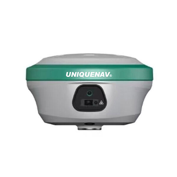
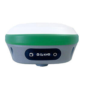
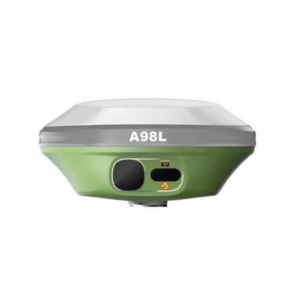
A differential GPS receiver represents a sophisticated positioning technology that significantly enhances location accuracy beyond standard GPS capabilities. This advanced system operates by using correction data from reference stations to eliminate common GPS errors, delivering precision measurements that can achieve accuracy within centimeters rather than meters. The differential GPS receiver works by receiving signals from both GPS satellites and ground-based reference stations, which continuously monitor satellite signals and calculate correction factors for atmospheric delays, satellite clock errors, and orbital variations. The core functionality of a differential GPS receiver centers on real-time error correction processing. When GPS satellites transmit positioning signals, various factors can introduce inaccuracies, including ionospheric and tropospheric delays, multipath effects, and satellite ephemeris errors. The differential GPS receiver addresses these challenges by incorporating correction data that compensates for these systematic errors. This correction process occurs through multiple communication methods, including radio links, cellular networks, or satellite-based augmentation systems. Technological features of modern differential GPS receivers include multi-frequency signal processing capabilities, which allow simultaneous tracking of L1, L2, and L5 GPS frequencies. Advanced models incorporate multi-constellation support, enabling compatibility with GPS, GLONASS, Galileo, and BeiDou satellite systems. The receivers feature robust signal processing algorithms that filter noise and maintain lock on satellite signals even in challenging environments. Many units include integrated communication modules for receiving correction data through various transmission methods. Applications for differential GPS receivers span numerous industries and sectors. Surveying and mapping professionals rely on these devices for precise boundary determination, topographic surveys, and construction layout work. Agricultural operations utilize differential GPS receivers for precision farming techniques, including automated steering systems, variable rate applications, and field mapping. Maritime navigation benefits from enhanced positioning accuracy for port approaches, channel navigation, and offshore operations. Aviation applications include precision approach and landing systems that require centimeter-level accuracy for safety-critical operations.

Popular Products

The differential GPS receiver delivers exceptional positioning accuracy that transforms how professionals approach location-dependent tasks. Standard GPS systems typically provide accuracy within 3-5 meters under optimal conditions, but differential GPS receivers consistently achieve sub-meter precision, with many systems delivering centimeter-level accuracy. This dramatic improvement enables users to complete tasks that demand precise positioning with confidence and reliability. Users experience significant time savings through increased efficiency in field operations. The enhanced accuracy eliminates the need for repeated measurements and reduces rework caused by positioning errors. Survey teams can complete projects faster since they spend less time verifying measurements and making corrections. Construction crews benefit from accurate initial positioning that prevents costly mistakes during building foundation work and utility installations. The differential GPS receiver provides consistent performance across various environmental conditions. Unlike standard GPS systems that may struggle with accuracy in challenging terrain or near large structures, differential systems maintain reliable positioning through advanced error correction algorithms. This consistency proves invaluable for professionals working in urban environments, dense forests, or mountainous regions where GPS signals face interference. Cost-effectiveness emerges as a major advantage when considering long-term operational benefits. While the initial investment in a differential GPS receiver may exceed standard GPS costs, the system pays for itself through reduced project timelines, fewer errors requiring correction, and improved work quality. Organizations report significant savings in labor costs and materials waste when using differential GPS technology for precision applications. The technology offers seamless integration with existing workflows and equipment. Modern differential GPS receivers connect easily with mapping software, construction equipment, and agricultural machinery through standardized communication protocols. This compatibility allows users to upgrade their positioning accuracy without completely replacing their existing technology infrastructure. Real-time correction capabilities ensure that users receive immediate feedback about positioning accuracy. The differential GPS receiver continuously processes correction data, providing instant alerts when accuracy falls below specified thresholds. This real-time monitoring prevents users from unknowingly working with degraded positioning data, maintaining quality standards throughout project execution. Enhanced productivity results from the ability to work confidently in challenging conditions. Weather conditions that might force delays with standard GPS systems often do not affect differential GPS receiver performance. Users can maintain productive schedules regardless of atmospheric conditions that typically introduce GPS errors.

Tips And Tricks

Top Tips for Using High Accuracy Handheld GPS in the Field

27

Nov

Top Tips for Using High Accuracy Handheld GPS in the Field

Professional fieldwork demands precision, reliability, and efficiency in positioning technology. Modern surveying, construction, and geospatial applications require positioning solutions that deliver centimeter-level accuracy while maintaining the po...
View More
What Should Buyers Compare When Sourcing RTK GPS Equipment?

13

Jan

What Should Buyers Compare When Sourcing RTK GPS Equipment?

Modern construction, surveying, and agricultural operations increasingly rely on precise positioning technology to achieve millimeter-level accuracy in their work. When sourcing RTK GPS equipment, buyers face numerous technical specifications, featur...
View More
How Does a Digital Level Improve Accuracy in Construction Measurements?

13

Jan

How Does a Digital Level Improve Accuracy in Construction Measurements?

Construction professionals understand that precision forms the foundation of every successful project. Modern building techniques demand measurement accuracy that surpasses traditional methods, making the digital level an indispensable tool for contr...
View More
How Does an Auto Level Improve Site-Leveling Efficiency?

11

Feb

How Does an Auto Level Improve Site-Leveling Efficiency?

Construction and surveying professionals consistently seek tools that enhance precision while reducing time-consuming manual processes. The auto level stands as one of the most crucial instruments in modern site-leveling operations, transforming how ...
View More

Get a Free Quote

Our representative will contact you soon.
Email
Name
Company Name
Message
0/1000

differential gps receiver

Centimeter-Level Precision Technology

Centimeter-Level Precision Technology

The differential GPS receiver achieves remarkable centimeter-level precision through sophisticated error correction technology that revolutionizes positioning accuracy standards. This exceptional precision stems from the system's ability to process correction data from strategically positioned reference stations that continuously monitor GPS satellite signals and calculate real-time error corrections. The reference stations detect common GPS errors including atmospheric delays, satellite clock drift, and orbital variations, then transmit correction factors to differential GPS receivers in the field. This process eliminates systematic errors that typically affect standard GPS positioning, resulting in accuracy improvements of 10 to 100 times compared to standalone GPS systems. The technology employs carrier-phase measurements and real-time kinematic processing to achieve this unprecedented accuracy level. Professional surveyors particularly benefit from this precision when establishing property boundaries, conducting topographic surveys, or performing construction stakeout work where millimeter accuracy can prevent costly legal disputes and construction errors. Agricultural applications leverage this precision for autonomous vehicle guidance systems that maintain exact row spacing and prevent crop damage through precise steering control. The centimeter-level accuracy enables farmers to implement precision agriculture techniques including variable rate seeding, fertilizer application, and harvest operations that maximize yield while minimizing input costs. Construction and engineering projects require this level of precision for foundation work, utility installations, and infrastructure development where small positioning errors can cascade into major problems. The differential GPS receiver delivers consistent centimeter-level performance regardless of project scale, from small residential surveys to large infrastructure developments. This reliability allows professionals to work with confidence knowing their positioning data meets the most stringent accuracy requirements. The technology maintains this precision throughout extended operating periods, with built-in quality assurance features that continuously monitor accuracy levels and alert users when performance falls below specified thresholds. Advanced signal processing algorithms filter environmental interference and multipath effects that can degrade positioning accuracy, ensuring consistent centimeter-level performance across diverse working conditions. Users appreciate the immediate productivity gains that result from this enhanced accuracy, as projects progress more efficiently without the delays associated with measurement verification and error correction procedures required by less accurate positioning systems.
Multi-Constellation Satellite Compatibility

Multi-Constellation Satellite Compatibility

The differential GPS receiver incorporates comprehensive multi-constellation satellite compatibility that dramatically improves positioning reliability and availability across all operating environments. This advanced capability enables simultaneous signal reception from GPS, GLONASS, Galileo, and BeiDou satellite constellations, effectively quadrupling the number of available positioning satellites compared to GPS-only systems. The expanded satellite constellation access provides several critical advantages that enhance user productivity and system reliability. Increased satellite visibility ensures consistent positioning performance in challenging environments where buildings, terrain, or vegetation might obstruct signals from individual constellations. Urban professionals working among tall structures benefit enormously from this multi-constellation approach, as the system maintains accurate positioning even when GPS satellites are blocked by buildings or infrastructure. The differential GPS receiver automatically selects the optimal combination of satellites from all available constellations, continuously optimizing positioning accuracy and reliability based on current satellite geometry and signal quality. This intelligent satellite selection process occurs transparently, requiring no user intervention while delivering superior performance compared to single-constellation systems. Forest and mining operations particularly value this capability since dense canopy cover or steep terrain walls can severely limit GPS-only system performance, but multi-constellation support maintains reliable positioning through alternative satellite access. The technology provides faster position acquisition times since the receiver can lock onto signals from multiple satellite constellations simultaneously. Users experience reduced wait times when initializing the system or reacquiring satellite signals after temporary obstructions, maintaining productive workflows without positioning delays. International users benefit significantly from multi-constellation compatibility since different regions have varying satellite constellation coverage strengths. GLONASS provides excellent coverage in northern latitudes, Galileo offers strong European performance, and BeiDou excels in Asia-Pacific regions, while GPS maintains global coverage standards. The differential GPS receiver seamlessly operates worldwide by automatically adapting to local constellation strengths and availability. Redundancy features enhance system reliability since signal loss from one constellation does not compromise positioning capability when other constellations remain available. This backup capability proves essential for mission-critical applications where positioning continuity cannot be interrupted. Emergency response teams, maritime navigation, and aviation operations rely on this redundancy to maintain operational capability under adverse conditions that might affect individual satellite constellations.
Real-Time Correction Processing

Real-Time Correction Processing

The differential GPS receiver excels through its sophisticated real-time correction processing capability that continuously enhances positioning accuracy by immediately applying error corrections as they become available. This dynamic correction system operates by receiving and processing correction data streams from reference station networks, satellite-based augmentation systems, or cellular communication links, then instantly applying these corrections to GPS positioning calculations. The real-time aspect proves crucial for applications requiring immediate accurate positioning feedback, eliminating the delays associated with post-processing correction methods used by less advanced systems. Professional users benefit from instant positioning confidence since they can verify accuracy in real-time rather than discovering errors after completing field work. The correction processing algorithms continuously analyze incoming data quality and automatically switch between correction sources to maintain optimal performance, ensuring uninterrupted accurate positioning even when primary correction sources experience temporary outages. Construction equipment operators particularly appreciate this real-time capability when performing grade control work, excavation operations, or material placement tasks where immediate position feedback prevents costly mistakes and rework. The differential GPS receiver processes multiple correction data formats including RTCM, CMR, and proprietary formats, providing compatibility with various correction service providers and reference station networks. This flexibility allows users to select correction services based on local availability, cost considerations, or specific accuracy requirements without being locked into single-source solutions. Marine applications leverage real-time correction processing for harbor approaches, channel navigation, and dynamic positioning operations where immediate accurate feedback is essential for safe vessel operation. The system maintains correction processing performance across varying communication link qualities, automatically adjusting to available bandwidth and signal conditions while preserving maximum possible accuracy. Advanced buffering and prediction algorithms ensure continuous positioning accuracy even during brief correction data interruptions, maintaining operational continuity in challenging communication environments. Agricultural automation systems depend on real-time correction processing for autonomous vehicle guidance, implement control, and field mapping operations where delayed correction application would compromise operational efficiency and accuracy. The differential GPS receiver provides user-configurable correction processing parameters, allowing customization for specific application requirements while maintaining ease of operation for non-technical users. Quality monitoring features continuously assess correction data validity and positioning accuracy, providing real-time status indicators that keep users informed about system performance and any potential accuracy limitations. Emergency alert capabilities immediately notify users when correction processing encounters problems that might affect positioning accuracy, enabling proactive responses that maintain work quality and prevent errors from propagating through ongoing operations.

Get a Free Quote

Our representative will contact you soon.
Email
Name
Company Name
Message
0/1000