Rugged GNSS Receiver: Professional-Grade Navigation Technology for Extreme Environments

All Categories

rugged gnss receiver

A rugged GNSS receiver represents the pinnacle of satellite navigation technology designed specifically for demanding environments and professional applications. This sophisticated positioning device combines Global Navigation Satellite System capabilities with military-grade construction to deliver precise location data under extreme conditions. The rugged GNSS receiver integrates multiple satellite constellations including GPS, GLONASS, Galileo, and BeiDou to ensure maximum accuracy and reliability across diverse operational scenarios. The primary functions of a rugged GNSS receiver encompass high-precision positioning, real-time kinematic surveying, and continuous tracking capabilities. These devices feature advanced signal processing algorithms that maintain lock on satellite signals even in challenging environments with heavy canopy cover, urban canyons, or electromagnetic interference. The rugged GNSS receiver incorporates sophisticated error correction mechanisms and multi-frequency reception to achieve centimeter-level accuracy for critical applications. Technological features include waterproof housings rated to IP67 or higher standards, shock-resistant internal components, and extended operating temperature ranges from -40°C to +70°C. The rugged GNSS receiver utilizes advanced antenna technology with enhanced gain patterns and anti-jamming capabilities to ensure reliable signal reception. Modern units integrate Bluetooth and WiFi connectivity for seamless data transfer and remote monitoring capabilities. Applications span numerous industries including surveying, construction, agriculture, military operations, search and rescue missions, and scientific research. The rugged GNSS receiver proves invaluable for precision farming applications, enabling variable rate application and automated guidance systems. Construction professionals rely on these devices for site layout, equipment guidance, and quality control processes. Military and emergency response teams depend on rugged GNSS receiver units for navigation, coordination, and mission-critical positioning tasks where failure is not an option.

New Product Recommendations

The rugged GNSS receiver delivers exceptional durability that significantly reduces equipment replacement costs and minimizes operational downtime. Unlike standard consumer devices, these professional-grade units withstand drops from heights exceeding two meters, resist water immersion up to three meters depth, and continue operating in dust storms and extreme weather conditions. This robust construction translates directly into lower total cost of ownership for businesses and organizations. Users experience enhanced productivity through reliable performance in challenging environments where conventional devices fail completely. The rugged GNSS receiver maintains consistent accuracy levels regardless of environmental stressors, ensuring project timelines stay on track and data collection remains uninterrupted. Advanced battery management systems provide extended operational periods, often exceeding 12 hours of continuous use, reducing the need for frequent charging breaks and increasing field efficiency. The superior accuracy capabilities of a rugged GNSS receiver eliminate costly rework and measurement errors that plague projects using inferior positioning equipment. Centimeter-level precision reduces material waste in construction applications and improves crop yield optimization in agricultural settings. Real-time correction services integrated into these devices provide immediate feedback, allowing operators to make adjustments instantly rather than discovering errors during post-processing phases. Versatile connectivity options enable seamless integration with existing workflows and software systems. The rugged GNSS receiver supports multiple data formats and communication protocols, ensuring compatibility with industry-standard applications and reducing training requirements for staff members. Cloud-based data management capabilities allow teams to access and share positioning information across multiple locations simultaneously, improving coordination and decision-making processes. The investment in a rugged GNSS receiver pays dividends through improved operational efficiency, reduced insurance claims from equipment damage, and enhanced safety for field personnel working in hazardous environments. Professional support services and extended warranty options provide additional peace of mind for organizations relying on precise positioning data for critical operations.

Practical Tips

GNSS RTK: The Ultimate Guide to Real-Time Kinematic Surveying

27

Nov

GNSS RTK: The Ultimate Guide to Real-Time Kinematic Surveying

Real-Time Kinematic (RTK) technology has revolutionized the field of surveying by providing centimeter-level accuracy in positioning measurements. This advanced Global Navigation Satellite System (GNSS) technique enables surveyors, construction profe...
View More
GNSS RTK vs. Traditional Surveying: What’s the Difference?

27

Nov

GNSS RTK vs. Traditional Surveying: What’s the Difference?

Modern surveying has undergone a revolutionary transformation with the introduction of Global Navigation Satellite Systems (GNSS) technology, particularly Real-Time Kinematic (RTK) positioning. While traditional surveying methods have served the cons...
View More
How Do RTK GNSS Receivers Maintain Stability in Complex Terrains?

22

Dec

How Do RTK GNSS Receivers Maintain Stability in Complex Terrains?

Navigation accuracy in challenging environments has become a critical requirement across industries ranging from construction and surveying to autonomous vehicles and precision agriculture. RTK GNSS receivers represent the pinnacle of satellite-based...
View More
How Does a Theodolite Compare to Total Stations in Practical Use?

11

Feb

How Does a Theodolite Compare to Total Stations in Practical Use?

Surveying professionals and construction engineers face critical decisions when selecting measurement instruments for their projects. The choice between traditional surveying tools and modern integrated systems can significantly impact project effici...
View More

Get a Free Quote

Our representative will contact you soon.
Email
Name
Company Name
Message
0/1000

rugged gnss receiver

Military-Grade Durability and Environmental Protection

Military-Grade Durability and Environmental Protection

The rugged GNSS receiver stands apart from consumer-grade alternatives through its exceptional environmental resistance and military-specification construction standards. These devices undergo rigorous testing protocols that simulate years of harsh field conditions within controlled laboratory environments. The housing materials utilize aerospace-grade aluminum alloys and reinforced polymer composites that resist corrosion, impact damage, and thermal expansion under extreme temperature variations. Sealed connector systems prevent moisture infiltration while maintaining reliable electrical connections even after thousands of mating cycles. The internal shock mounting systems protect sensitive electronic components from vibration damage during transportation and operation in heavy machinery environments. Temperature compensation circuits ensure accurate performance across operating ranges from arctic conditions to desert environments where surface temperatures exceed 60°C. The rugged GNSS receiver features multiple layers of protection including conformal coatings on circuit boards, gasket-sealed battery compartments, and reinforced antenna connections. Electromagnetic interference shielding prevents signal degradation in industrial environments with high-power electrical equipment or radio frequency emissions. Salt spray resistance testing validates performance in marine applications where corrosive environments rapidly destroy unprotected electronics. The device maintains functionality after submersion testing that exceeds industry standards, providing confidence for users working near water bodies or in flood-prone regions. Impact resistance testing involves repeated drops onto concrete surfaces from various angles, ensuring the rugged GNSS receiver continues operating after accidental falls from scaffolding, vehicles, or survey tripods. Dust ingress protection prevents particle accumulation that could interfere with cooling systems or electrical contacts. These comprehensive protection measures result in mean time between failures that exceeds five years under normal operating conditions, significantly reducing replacement costs and operational disruptions for professional users who depend on reliable positioning data for mission-critical applications.
Multi-Constellation Tracking and Advanced Signal Processing

Multi-Constellation Tracking and Advanced Signal Processing

The rugged GNSS receiver incorporates cutting-edge signal processing technology that simultaneously tracks multiple satellite constellations to deliver unprecedented positioning accuracy and reliability. Advanced correlation algorithms process signals from GPS, GLONASS, Galileo, BeiDou, and regional augmentation systems concurrently, creating a robust positioning solution that maintains accuracy even when individual satellites become temporarily unavailable. The multi-frequency reception capability enables the device to utilize L1, L2, and L5 signals, providing enhanced ionospheric correction and improved performance in challenging signal environments. Real-time kinematic processing algorithms achieve centimeter-level accuracy by analyzing carrier phase measurements and applying sophisticated error modeling techniques. The rugged GNSS receiver employs adaptive filtering mechanisms that automatically adjust tracking parameters based on environmental conditions and signal quality metrics. Anti-jamming technology protects against intentional interference while anti-spoofing algorithms verify signal authenticity to prevent location manipulation attempts. The integrated inertial measurement unit provides continuous positioning updates during temporary satellite signal loss, ensuring uninterrupted operation in tunnels, under bridges, or in dense urban environments. Advanced multipath mitigation techniques analyze signal reflection patterns and eliminate positioning errors caused by buildings, terrain features, or metallic structures. The device automatically selects optimal satellite combinations based on geometric dilution of precision calculations, maximizing accuracy while minimizing computational overhead. Atmospheric modeling algorithms compensate for tropospheric and ionospheric delays that affect signal propagation, particularly important for long-baseline surveying applications. The rugged GNSS receiver supports various correction services including satellite-based augmentation systems, network RTK services, and post-processing differential correction methods. Machine learning algorithms continuously optimize tracking performance by analyzing historical data patterns and predicting optimal configuration parameters for specific operating environments, ensuring users achieve maximum accuracy potential from their rugged GNSS receiver investment.
Professional Integration and Workflow Optimization

Professional Integration and Workflow Optimization

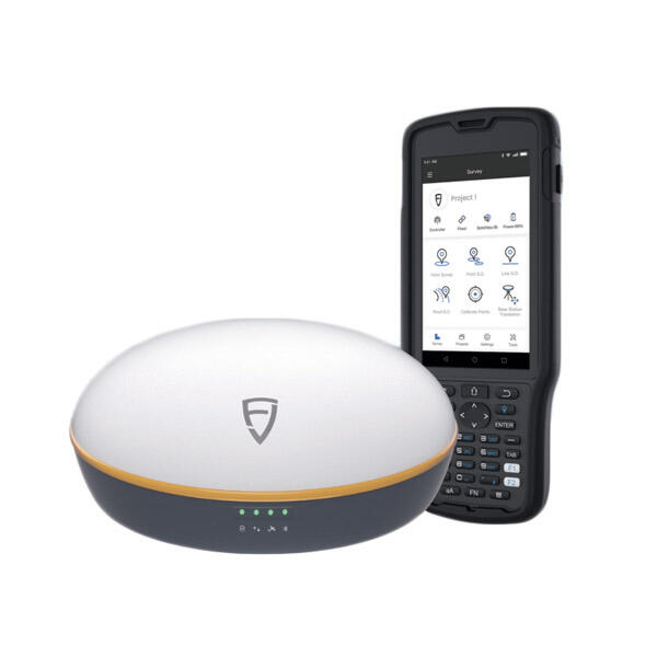
The rugged GNSS receiver excels in professional environments through comprehensive integration capabilities that streamline workflows and enhance productivity across diverse applications. Advanced data management systems automatically organize positioning information with timestamps, coordinate transformations, and quality metrics that facilitate immediate analysis and reporting. The device supports over thirty coordinate systems and map projections, enabling seamless integration with existing Geographic Information Systems and Computer-Aided Design software platforms used by surveying, engineering, and construction professionals. Customizable data collection templates allow users to configure the rugged GNSS receiver for specific project requirements, reducing setup time and minimizing operator errors during field operations. Real-time data transmission capabilities enable immediate sharing of positioning information with remote team members, supervisors, and clients through secure cloud-based platforms. The integrated project management features track survey progress, calculate area measurements, and generate preliminary reports directly in the field, eliminating delays associated with office-based post-processing workflows. Advanced stakeout functionality guides operators to predetermined coordinates with centimeter-level accuracy, essential for construction layout and infrastructure installation projects. The rugged GNSS receiver interfaces seamlessly with robotic total stations, laser scanners, and unmanned aerial vehicles to create comprehensive measurement solutions that combine multiple data collection methodologies. Customizable alarm systems alert operators to accuracy degradation, battery depletion, or communication failures, preventing data loss and ensuring quality control standards. The device maintains detailed audit trails that document measurement procedures, operator actions, and environmental conditions for compliance with industry standards and legal requirements. Mobile application support enables remote monitoring and control of multiple rugged GNSS receiver units from tablet computers or smartphones, improving supervision efficiency for large-scale projects. Advanced reporting capabilities generate professional documentation with embedded maps, statistical summaries, and graphical presentations suitable for client deliverables and regulatory submissions. The investment in a rugged GNSS receiver delivers measurable returns through reduced field time, improved accuracy, and enhanced project documentation capabilities that distinguish professional service providers in competitive markets.

Get a Free Quote

Our representative will contact you soon.
Email
Name
Company Name
Message
0/1000