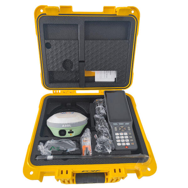
rtk survey machine
The RTK survey machine represents a revolutionary advancement in precision surveying technology, combining real-time kinematic positioning with cutting-edge GPS capabilities to deliver unparalleled accuracy in field measurements. This sophisticated surveying instrument utilizes satellite navigation systems to provide centimeter-level precision, making it an indispensable tool for modern surveying professionals. The RTK survey machine operates by receiving corrections from a base station or network of reference stations, enabling surveyors to achieve positioning accuracy within 1-2 centimeters in real-time. This remarkable precision capability transforms how construction projects, land development initiatives, and topographic mapping operations are conducted. The device integrates advanced GNSS technology with robust data processing algorithms, allowing users to capture detailed spatial information with unprecedented reliability. Key technological features include multi-constellation satellite tracking, which supports GPS, GLONASS, Galileo, and BeiDou systems simultaneously for enhanced signal availability and positioning stability. The RTK survey machine incorporates weather-resistant housing designed to withstand harsh field conditions, ensuring consistent performance across diverse environmental challenges. Modern units feature intuitive touchscreen interfaces that simplify operation while providing comprehensive data visualization capabilities. Applications span numerous industries including civil engineering, mining operations, agricultural planning, environmental monitoring, and archaeological documentation. Construction professionals rely on RTK survey machines for precise site layout, grade checking, and infrastructure development projects. Land surveyors utilize these instruments for boundary determination, property mapping, and cadastral surveys that require legal-grade accuracy. The technology proves invaluable for monitoring structural deformation, tracking geological movements, and conducting precise volumetric calculations. Mining companies depend on RTK survey machines for ore body mapping, pit design, and equipment guidance systems that optimize extraction processes. Agricultural applications include precision farming initiatives, drainage system design, and field mapping for crop management optimization.