RTK GNSS System: Professional Real-Time Positioning Technology for Surveying and Construction Applications

All Categories

rtk gnss system

The RTK GNSS system represents a revolutionary advancement in satellite-based positioning technology that delivers unprecedented accuracy for professional surveying, construction, and mapping applications. Real-Time Kinematic Global Navigation Satellite System technology combines traditional GNSS receivers with sophisticated correction algorithms to achieve centimeter-level positioning accuracy in real-time operations. This cutting-edge RTK GNSS system operates by establishing a reference station at a known coordinate position, which continuously receives satellite signals and calculates positioning errors caused by atmospheric conditions, satellite clock drift, and orbital variations. The reference station then transmits these correction data to mobile RTK GNSS system units operating within the coverage area, typically ranging from 10 to 50 kilometers depending on environmental conditions and equipment specifications. The mobile receivers apply these corrections instantaneously, eliminating common sources of positioning errors and delivering horizontal accuracy within 1-3 centimeters and vertical accuracy within 2-5 centimeters under optimal conditions. Modern RTK GNSS system implementations support multiple satellite constellation tracking, including GPS, GLONASS, Galileo, and BeiDou systems, ensuring robust signal availability and enhanced positioning reliability across diverse geographical locations and challenging environments. The technology incorporates advanced signal processing algorithms, multi-frequency carrier phase measurements, and sophisticated ambiguity resolution techniques to maintain consistent performance standards. Contemporary RTK GNSS system solutions feature integrated communication modules supporting various data transmission methods, including radio frequency links, cellular networks, and internet protocols for maximum operational flexibility. These systems typically include comprehensive data logging capabilities, coordinate transformation functions, and compatibility with industry-standard surveying software platforms, making them indispensable tools for professional applications requiring precise positioning measurements and real-time coordinate determination.

New Product Recommendations

The RTK GNSS system delivers exceptional positioning accuracy that surpasses conventional GPS technology by significant margins, providing users with centimeter-level precision that transforms surveying, construction layout, and mapping workflows. This remarkable accuracy eliminates the need for time-consuming traditional surveying methods, reducing project completion times while maintaining superior measurement quality standards. Users experience dramatic productivity improvements when implementing RTK GNSS system technology, as field crews can establish precise control points, conduct topographic surveys, and perform construction stakeout operations with remarkable efficiency compared to conventional total station methodologies. The RTK GNSS system operates continuously in real-time, providing instant position corrections that allow operators to make immediate decisions and adjustments without waiting for post-processing calculations or returning to office environments for data analysis. This real-time capability proves invaluable for construction projects where schedule adherence and rapid progress measurements directly impact project profitability and completion timelines. Cost effectiveness represents another compelling advantage of RTK GNSS system implementation, as organizations reduce labor requirements, minimize equipment transportation needs, and eliminate expenses associated with establishing traditional survey control networks. Field teams using RTK GNSS system technology can cover larger areas with fewer personnel, completing survey projects that previously required multiple days in significantly shorter timeframes. The system's versatility enables seamless transitions between different surveying tasks, from boundary determination to construction layout, without requiring additional equipment setup or calibration procedures. Weather independence distinguishes RTK GNSS system performance from optical surveying instruments, as satellite-based positioning continues functioning effectively during overcast conditions, light precipitation, and temperature variations that would compromise traditional surveying equipment accuracy. Modern RTK GNSS system solutions integrate seamlessly with existing surveying workflows, supporting popular data formats and coordinate systems while maintaining compatibility with established project management software platforms. User-friendly interfaces and intuitive operation procedures ensure rapid learning curves for field personnel, minimizing training requirements and accelerating technology adoption across surveying teams. The RTK GNSS system provides consistent measurement quality regardless of terrain complexity, operating effectively across flat agricultural fields, steep construction sites, and challenging environmental conditions where conventional surveying methods face significant limitations.

Tips And Tricks

Choosing the Best GNSS RTK System for Your Project

27

Nov

Choosing the Best GNSS RTK System for Your Project

When precision positioning is critical for your surveying, construction, or engineering project, selecting the right GNSS RTK system becomes a pivotal decision that can determine project success. Modern surveying demands centimeter-level accuracy, re...
View More
What Should Buyers Compare When Sourcing RTK GPS Equipment?

13

Jan

What Should Buyers Compare When Sourcing RTK GPS Equipment?

Modern construction, surveying, and agricultural operations increasingly rely on precise positioning technology to achieve millimeter-level accuracy in their work. When sourcing RTK GPS equipment, buyers face numerous technical specifications, featur...
View More
Why Are Digital Levels Preferred Over Traditional Bubble Levels?

11

Feb

Why Are Digital Levels Preferred Over Traditional Bubble Levels?

The construction and engineering industries have witnessed a significant transformation in measurement tools over the past decade. Among these advancements, digital levels have emerged as the preferred choice for professionals who demand precision, e...
View More
What Key Features Should You Check When Buying an Auto Level?

11

Feb

What Key Features Should You Check When Buying an Auto Level?

When precision matters most in construction and surveying projects, selecting the right auto level becomes a critical decision that can impact the success of your entire operation. An auto level serves as the backbone of accurate height measurements ...
View More

Get a Free Quote

Our representative will contact you soon.
Email
Name
Company Name
Message
0/1000

rtk gnss system

Unmatched Real-Time Accuracy for Professional Applications

Unmatched Real-Time Accuracy for Professional Applications

The RTK GNSS system achieves extraordinary positioning accuracy through sophisticated carrier phase measurement techniques that differentiate it from standard GPS technology and conventional surveying methods. This advanced positioning capability stems from the system's ability to track carrier wave phases from multiple satellite signals simultaneously, processing these measurements through complex mathematical algorithms that resolve carrier phase ambiguities in real-time. The RTK GNSS system maintains horizontal positioning accuracy within 8-15 millimeters plus 1 part per million of baseline distance under optimal conditions, while vertical accuracy typically ranges from 15-20 millimeters plus 1 part per million, representing a dramatic improvement over code-based positioning systems that achieve meter-level accuracy at best. This exceptional precision proves essential for applications requiring strict tolerance adherence, including precision agriculture guidance systems, construction foundation layout, utility infrastructure mapping, and cadastral boundary surveys where measurement errors can result in costly disputes or project delays. The RTK GNSS system accomplishes this remarkable accuracy by continuously comparing carrier phase measurements from mobile receivers with reference station observations, calculating and applying corrections for atmospheric delays, satellite orbit errors, and clock drift variations that affect signal propagation. The system processes these corrections instantaneously through robust communication links, ensuring that field operators receive position solutions with minimal latency, typically within 1-2 seconds of measurement initiation. Professional surveyors utilizing RTK GNSS system technology can confidently establish property boundaries, conduct topographic mapping, and perform construction layout operations knowing that their measurements meet or exceed industry accuracy standards and regulatory requirements. The technology's reliability stems from its multi-constellation tracking capabilities, utilizing signals from GPS, GLONASS, Galileo, and BeiDou satellite systems to ensure robust positioning solutions even in challenging environments with limited sky visibility or signal obstruction. This comprehensive satellite tracking approach enables the RTK GNSS system to maintain consistent accuracy performance across diverse geographical locations and operational conditions, providing users with dependable positioning solutions for critical surveying applications.
Enhanced Operational Efficiency and Productivity

Enhanced Operational Efficiency and Productivity

The RTK GNSS system revolutionizes surveying productivity by eliminating traditional workflow bottlenecks and enabling single-operator measurement collection across extensive project areas without compromising accuracy standards. Unlike conventional total station surveying that requires line-of-sight visibility between instruments and prism targets, the RTK GNSS system operates through satellite signal reception, allowing surveyors to collect coordinate data independently without establishing intervisible control networks or coordinating multiple field crew members. This operational independence translates directly into increased daily productivity, as experienced operators using RTK GNSS system technology can typically collect 300-500 survey points per day compared to 100-200 points achievable through traditional surveying methods. The system's mobility advantages become particularly evident during large-area topographic surveys, boundary determinations, and construction progress monitoring where crews can move freely across project sites without equipment setup delays or sight line restrictions. Real-time coordinate display capabilities enable immediate quality assurance verification, allowing operators to identify and address potential measurement issues while remaining in the field rather than discovering problems during subsequent office processing sessions. The RTK GNSS system supports rapid project startup procedures, as reference station installation and system initialization typically require 15-30 minutes compared to hours needed for establishing conventional survey control networks. Field crews benefit from simplified equipment transportation requirements, as complete RTK GNSS system solutions weigh significantly less than comparable total station configurations while providing superior measurement capabilities. The technology's versatility enables seamless transitions between different survey applications within single field sessions, supporting topographic data collection, construction stakeout, boundary surveys, and utility mapping without equipment changes or recalibration procedures. Automated data logging features eliminate manual recording errors while ensuring comprehensive project documentation that meets professional surveying standards and regulatory requirements. Integration capabilities with modern survey software platforms enable real-time data processing, coordinate transformations, and quality control analysis, streamlining project workflows from initial measurement collection through final deliverable preparation.
Versatile Applications Across Multiple Industries

Versatile Applications Across Multiple Industries

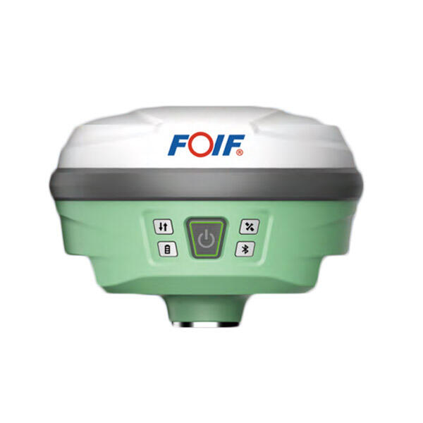
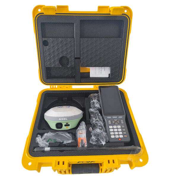
The RTK GNSS system demonstrates remarkable adaptability across diverse industry sectors, providing specialized solutions for construction management, precision agriculture, infrastructure development, environmental monitoring, and geospatial mapping applications. Construction professionals leverage RTK GNSS system capabilities for accurate building layout, foundation positioning, earthwork volume calculations, and progress monitoring throughout project lifecycles. The technology enables construction crews to establish precise building corners, utility line locations, and grade control points directly from digital design files, eliminating traditional surveying delays while ensuring millimeter-accurate construction alignment. Agricultural applications benefit tremendously from RTK GNSS system implementation, particularly in precision farming operations where accurate field mapping, crop monitoring, and automated machinery guidance systems require consistent centimeter-level positioning. Farmers utilizing RTK GNSS system technology can optimize fertilizer application patterns, implement variable rate seeding strategies, and conduct precise harvest monitoring while reducing input costs and maximizing crop yields through data-driven agricultural management practices. Infrastructure development projects depend on RTK GNSS system accuracy for highway design implementation, railway construction, pipeline installation, and utility network expansion where positioning errors can compromise structural integrity and operational safety. Environmental consulting applications utilize RTK GNSS system capabilities for wetland boundary delineation, contamination site mapping, ecological habitat monitoring, and natural resource inventory projects requiring precise coordinate determination and regulatory compliance documentation. Mining and quarry operations implement RTK GNSS system technology for resource exploration, extraction planning, volumetric calculations, and safety monitoring applications where accurate positioning directly impacts operational efficiency and regulatory compliance. Emergency response organizations utilize portable RTK GNSS system configurations for disaster assessment, evacuation planning, search and rescue operations, and infrastructure damage evaluation where rapid, accurate positioning information proves critical for effective response coordination. Archaeological investigations benefit from RTK GNSS system precision during artifact location recording, site boundary establishment, and excavation grid layout procedures where measurement accuracy preserves valuable historical information. Marine applications incorporate RTK GNSS system technology for hydrographic surveying, coastal mapping, dredging operations, and offshore construction projects requiring precise positioning in challenging aquatic environments.

Get a Free Quote

Our representative will contact you soon.
Email
Name
Company Name
Message
0/1000