Professional Total Station and Prism Systems - Precision Surveying Equipment for Construction and Engineering

All Categories

total station and prism

A total station and prism combination represents the cornerstone of modern surveying technology, revolutionizing how professionals measure distances, angles, and coordinates in construction, engineering, and mapping projects. The total station serves as an electronic theodolite integrated with electronic distance measurement capabilities, while the prism acts as a reflective target that enables precise measurements across vast distances. This sophisticated surveying instrument combines angle measurement, distance measurement, and data recording functions into one comprehensive device. The total station utilizes advanced laser technology to emit infrared signals that bounce off the prism and return to the instrument, calculating exact distances with remarkable accuracy. Modern total station and prism systems feature digital displays, onboard computers, and wireless connectivity options that streamline data collection and transfer processes. The prism component consists of corner cube reflectors made from high-quality optical glass, designed to reflect laser signals directly back to their source regardless of the angle of incidence within specific ranges. These reflective targets come in various sizes and mounting configurations, including handheld poles, tribrach adapters, and permanent mounting solutions. The technological integration between total station and prism enables surveyors to establish control networks, perform topographic surveys, stake out construction points, and monitor structural movements with millimeter-level precision. Contemporary total station models incorporate GPS capabilities, Bluetooth connectivity, and cloud-based data management systems that enhance productivity and accuracy. The prism technology has evolved to include specialized coatings and materials that maximize reflectivity while minimizing signal loss, ensuring reliable measurements even in challenging environmental conditions. This surveying solution supports multiple measurement modes including reflectorless measurements for inaccessible areas, though the total station and prism combination remains the gold standard for precision work requiring the highest accuracy standards.

New Products

The total station and prism system delivers exceptional measurement accuracy that surpasses traditional surveying methods, enabling professionals to achieve millimeter-level precision across distances exceeding several kilometers. This remarkable accuracy stems from advanced laser technology and sophisticated algorithms that compensate for atmospheric conditions, temperature variations, and other environmental factors that might affect measurement quality. Users experience significant time savings compared to conventional surveying techniques, as the total station and prism combination eliminates the need for multiple instrument setups and complex calculations. The electronic data collection capabilities built into modern total station systems automatically record measurements, coordinates, and field notes, reducing human error while accelerating project completion timelines. Construction teams benefit from real-time positioning feedback that allows immediate verification of stake-out points, preventing costly mistakes and rework scenarios. The versatility of total station and prism technology accommodates diverse project requirements, from large-scale infrastructure development to precise architectural surveys and everything in between. Weather resistance features protect both the total station instrument and prism components against harsh environmental conditions, ensuring reliable performance in rain, snow, dust, and extreme temperatures. The ergonomic design of modern total station units reduces operator fatigue during extended field sessions, while intuitive software interfaces minimize training requirements for new users. Cost-effectiveness becomes apparent through improved productivity, reduced labor requirements, and decreased material waste resulting from enhanced measurement precision. The total station and prism system supports seamless integration with CAD software, GIS platforms, and Building Information Modeling systems, creating efficient workflows from field measurement to final design documentation. Battery life improvements in contemporary total station models enable full-day operation without interruption, while quick-charge capabilities minimize downtime between projects. The prism technology offers multiple targeting options including mini prisms for confined spaces, 360-degree prisms for tracking applications, and specialized prisms for monitoring tasks. Quality control processes benefit tremendously from the ability to perform rapid accuracy checks and verification measurements, ensuring project specifications are met consistently throughout construction phases. Remote measurement capabilities allow operators to safely survey hazardous or inaccessible areas without compromising personal safety or measurement quality.

Practical Tips

GNSS RTK: The Ultimate Guide to Real-Time Kinematic Surveying

27

Nov

GNSS RTK: The Ultimate Guide to Real-Time Kinematic Surveying

Real-Time Kinematic (RTK) technology has revolutionized the field of surveying by providing centimeter-level accuracy in positioning measurements. This advanced Global Navigation Satellite System (GNSS) technique enables surveyors, construction profe...
View More
Choosing the Best GNSS RTK System for Your Project

27

Nov

Choosing the Best GNSS RTK System for Your Project

When precision positioning is critical for your surveying, construction, or engineering project, selecting the right GNSS RTK system becomes a pivotal decision that can determine project success. Modern surveying demands centimeter-level accuracy, re...
View More
GNSS RTK vs. Traditional Surveying: What’s the Difference?

27

Nov

GNSS RTK vs. Traditional Surveying: What’s the Difference?

Modern surveying has undergone a revolutionary transformation with the introduction of Global Navigation Satellite Systems (GNSS) technology, particularly Real-Time Kinematic (RTK) positioning. While traditional surveying methods have served the cons...
View More
Why Are Digital Levels Preferred Over Traditional Bubble Levels?

11

Feb

Why Are Digital Levels Preferred Over Traditional Bubble Levels?

The construction and engineering industries have witnessed a significant transformation in measurement tools over the past decade. Among these advancements, digital levels have emerged as the preferred choice for professionals who demand precision, e...
View More

Get a Free Quote

Our representative will contact you soon.
Email
Name
Company Name
Message
0/1000

total station and prism

Unmatched Precision and Reliability in Professional Surveying

Unmatched Precision and Reliability in Professional Surveying

The total station and prism combination delivers industry-leading measurement precision that transforms how construction and engineering professionals approach complex projects. Modern total station instruments achieve angular accuracy within 1 arc second and distance measurement precision of plus or minus 1 millimeter, establishing new standards for surveying excellence. This exceptional accuracy results from sophisticated electronic systems that continuously monitor and compensate for environmental variables including temperature fluctuations, atmospheric pressure changes, and humidity variations that traditionally compromised measurement reliability. The prism technology enhances this precision through advanced optical coatings and geometrically perfect corner cube designs that ensure consistent signal reflection regardless of positioning angles within operational ranges. Professional surveyors rely on this accuracy for critical applications including high-rise construction, bridge engineering, tunnel excavation, and precision manufacturing where measurement errors can result in catastrophic failures or significant financial losses. The total station and prism system maintains accuracy consistency across varying distances, from close-range detail surveys to long-distance control network establishment spanning several kilometers. Quality assurance protocols built into modern total station software automatically flag potential measurement discrepancies and prompt operators to verify questionable readings before accepting data. The reliability factor extends beyond measurement accuracy to encompass instrument durability and consistent performance under demanding field conditions. Rigorous testing procedures ensure total station and prism components withstand temperature extremes, shock impacts, dust infiltration, and moisture exposure commonly encountered in construction environments. This reliability translates into reduced instrument downtime, lower maintenance costs, and increased project efficiency. Professional users appreciate the confidence that comes from knowing their total station and prism measurements will stand up to legal scrutiny and regulatory compliance requirements. The precision capabilities enable innovative construction techniques including prefabrication verification, robotic construction guidance, and real-time structural monitoring systems that were previously impossible with conventional surveying methods.
Advanced Technology Integration for Modern Surveying Workflows

Advanced Technology Integration for Modern Surveying Workflows

Contemporary total station and prism systems incorporate cutting-edge technology features that revolutionize traditional surveying workflows and enhance operational efficiency across diverse project types. Bluetooth connectivity enables seamless data transfer between the total station and field computers, smartphones, or tablets, eliminating manual data entry errors and accelerating information processing speeds. Cloud-based data management systems allow real-time synchronization of survey measurements with project databases, enabling immediate access to current information for all team members regardless of their physical location. The total station and prism combination supports multiple measurement modes including robotic operation where the instrument automatically tracks prism movements, significantly reducing crew requirements for many surveying tasks. GPS integration within advanced total station models provides absolute positioning capabilities that complement traditional relative measurements, creating comprehensive positioning solutions for complex projects. Onboard computing power enables sophisticated calculations including coordinate transformations, area computations, volume calculations, and slope analysis without requiring external processing equipment. Touch-screen interfaces and intuitive menu systems reduce learning curves for new operators while providing experienced users with rapid access to advanced functions and customization options. The total station technology supports various prism configurations including 360-degree tracking prisms, mini prisms for confined spaces, and specialized monitoring prisms for automated measurement systems. Wireless communication capabilities allow remote operation of total station functions, improving safety in hazardous environments while maintaining full measurement accuracy. Digital imaging systems integrated into select total station models capture photographic documentation synchronized with measurement data, creating comprehensive records for future reference and verification purposes. Battery management systems optimize power consumption while providing extended operational periods, with smart charging algorithms that protect battery longevity and ensure reliable field performance. Software compatibility ensures seamless integration with popular CAD platforms, GIS systems, and construction management software, streamlining project workflows from initial survey through final documentation phases. The total station and prism system supports customizable measurement routines and automated sequences that standardize data collection procedures while reducing operator workload and potential errors.
Comprehensive Versatility for Diverse Professional Applications

Comprehensive Versatility for Diverse Professional Applications

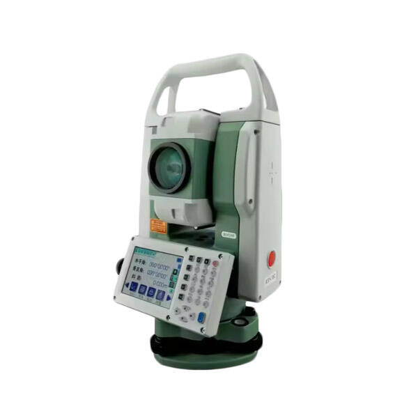
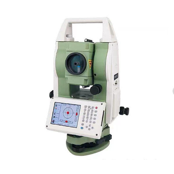
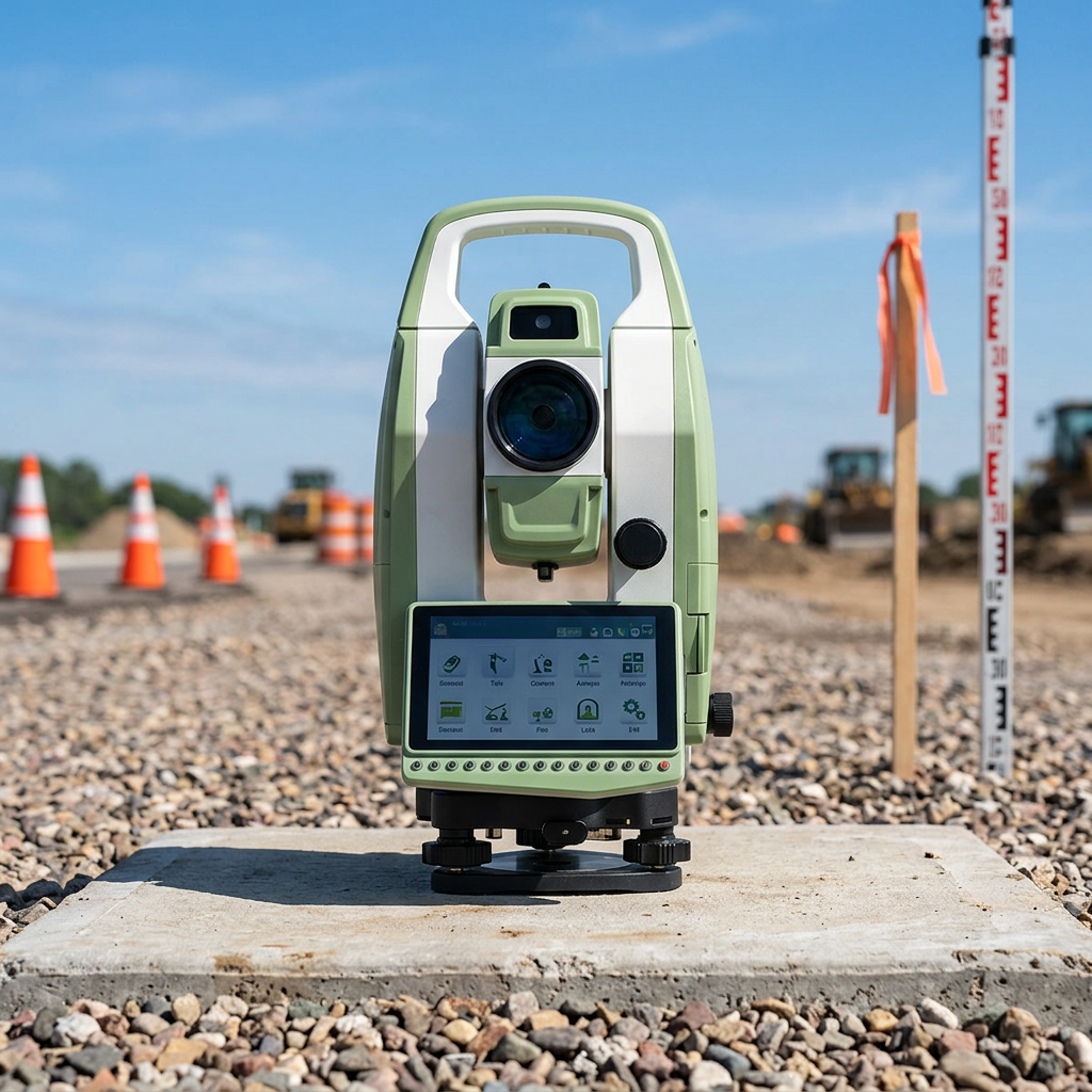
The total station and prism system demonstrates remarkable versatility by adapting to an extensive range of professional applications across construction, engineering, archaeology, mining, and environmental monitoring sectors. Construction professionals utilize total station and prism technology for site preparation, foundation layout, structural monitoring, and quality control verification throughout project lifecycles. Engineering applications include highway design surveys, bridge construction monitoring, dam safety assessments, and utility infrastructure mapping where precision measurements are critical for public safety and regulatory compliance. Archaeological teams employ total station and prism systems for site documentation, artifact positioning, and excavation grid establishment, preserving cultural heritage through accurate digital records. Mining operations benefit from total station capabilities in shaft surveying, stockpile volume calculations, and subsidence monitoring that ensure operational safety and environmental compliance. Environmental monitoring projects utilize the total station and prism combination for shoreline mapping, flood plain surveys, and ecosystem boundary delineation supporting conservation efforts and regulatory reporting requirements. Urban planning initiatives rely on total station accuracy for property boundary surveys, zoning verification, and infrastructure assessment that guide community development decisions. Industrial applications include manufacturing facility layout, equipment alignment verification, and production line optimization where precise positioning directly impacts operational efficiency and product quality. The total station and prism system accommodates both large-scale regional surveys and detailed local measurements, providing flexibility that eliminates the need for multiple specialized instruments. Temporary monitoring installations use automated total station systems with permanent prism networks to track structural movements, ground settlement, or equipment positioning over extended periods. Emergency response situations benefit from rapid deployment capabilities of portable total station and prism equipment for disaster assessment, evacuation route planning, and recovery infrastructure design. Educational institutions employ total station and prism technology for student training programs, research projects, and campus facility management, preparing the next generation of surveying professionals while supporting institutional operations. The adaptability extends to various measurement environments including indoor spaces, underground locations, and challenging outdoor conditions where conventional surveying methods prove inadequate or impractical.

Get a Free Quote

Our representative will contact you soon.
Email
Name
Company Name
Message
0/1000