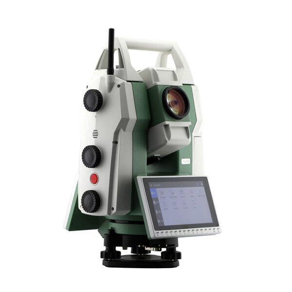
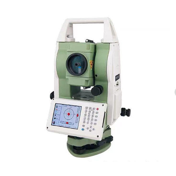
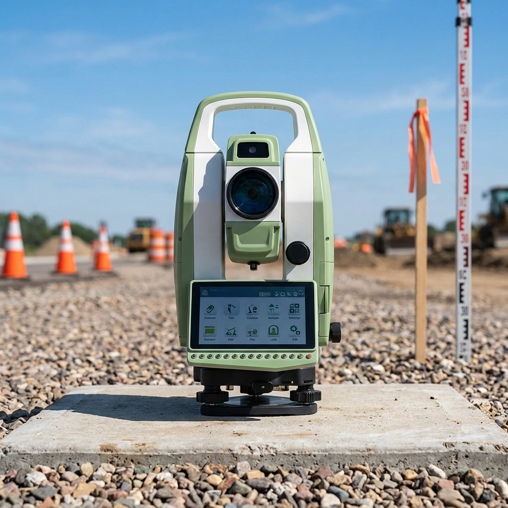
GNSS Total Station: Advanced Surveying Technology with Integrated Satellite Positioning and Precision Measurement

All Categories

gnss total station

A GNSS total station represents a revolutionary advancement in surveying technology, combining the precision of traditional total station measurements with the global positioning capabilities of Global Navigation Satellite Systems. This sophisticated instrument integrates electronic distance measurement, angle measurement, and satellite positioning into a single, powerful surveying solution. The GNSS total station operates by receiving signals from multiple satellite constellations including GPS, GLONASS, Galileo, and BeiDou, while simultaneously performing terrestrial measurements using laser technology. The main functions of a GNSS total station encompass comprehensive surveying tasks including topographic mapping, construction layout, monitoring applications, and geodetic measurements. The instrument automatically switches between GNSS positioning and conventional total station modes based on environmental conditions and measurement requirements. Technological features include advanced signal processing algorithms, real-time kinematic positioning capabilities, automated target recognition systems, and wireless connectivity options. The device incorporates sophisticated software that processes both satellite signals and terrestrial measurements, providing seamless integration of positioning data. Modern GNSS total station units feature high-resolution displays, intuitive user interfaces, and robust data storage capabilities. Applications span across construction projects, infrastructure development, mining operations, archaeological surveys, and environmental monitoring. The instrument proves invaluable for establishing control networks, performing boundary surveys, monitoring structural deformation, and executing precise engineering layouts. Its versatility makes it essential for professional surveyors, engineers, and construction teams requiring accurate positioning data in challenging environments where satellite coverage may be intermittent or obstructed by buildings, vegetation, or terrain features.

New Product Recommendations

The GNSS total station delivers exceptional versatility by combining two essential surveying technologies into one comprehensive instrument, eliminating the need for multiple devices and reducing equipment costs significantly. Users benefit from increased productivity as the system automatically selects the most appropriate measurement method based on current conditions, ensuring continuous operation even when satellite signals become temporarily unavailable. This seamless switching capability means surveyors can work efficiently in urban environments, forested areas, or confined spaces without interrupting their workflow. The instrument provides superior accuracy across various measurement ranges, delivering millimeter precision for both distance and angular measurements while maintaining centimeter-level positioning accuracy through GNSS technology. Time savings represent another crucial advantage, as the GNSS total station eliminates the need for traditional traverse setups and reduces the number of control points required for surveys. Setup procedures become faster and more straightforward, allowing teams to complete projects in shorter timeframes while maintaining professional standards. The device enhances measurement reliability through redundant positioning methods, enabling operators to verify results using both satellite and terrestrial measurements for critical applications. Weather resistance and durability features ensure consistent performance across diverse environmental conditions, from extreme temperatures to dusty or humid locations. Advanced data management capabilities streamline field-to-office workflows, with automatic data logging, cloud synchronization, and compatibility with popular survey software packages. The instrument reduces human error through automated measurement processes and intelligent quality control features that alert operators to potential issues. Cost-effectiveness improves over time as organizations require fewer instruments and personnel to complete equivalent surveying tasks. Training requirements diminish due to intuitive operation and automated functions, making the technology accessible to operators with varying experience levels. Remote monitoring capabilities enable supervisors to track project progress and verify measurement quality from off-site locations, enhancing project management efficiency and client communication.

Latest News

Why Do Mapping Teams Prefer RTK for Real-Time Positioning Tasks?

22

Dec

Why Do Mapping Teams Prefer RTK for Real-Time Positioning Tasks?

Modern mapping teams face unprecedented demands for precision and speed in their surveying operations. The evolution of positioning technologies has revolutionized how professionals approach field data collection, with RTK for real-time positioning e...
View More
What Should Buyers Compare When Sourcing RTK GPS Equipment?

13

Jan

What Should Buyers Compare When Sourcing RTK GPS Equipment?

Modern construction, surveying, and agricultural operations increasingly rely on precise positioning technology to achieve millimeter-level accuracy in their work. When sourcing RTK GPS equipment, buyers face numerous technical specifications, featur...
View More
What Should You Evaluate Before Purchasing a Total Station?

13

Jan

What Should You Evaluate Before Purchasing a Total Station?

When investing in surveying equipment, selecting the right total station represents one of the most critical decisions for engineering professionals, construction teams, and surveying companies. A total station serves as the backbone of precise measu...
View More
How Does RTK GPS Reduce Errors in Professional Survey Work?

13

Jan

How Does RTK GPS Reduce Errors in Professional Survey Work?

Professional surveying demands precision that can make the difference between project success and costly mistakes. Traditional GPS systems, while revolutionary, often fall short of the accuracy requirements needed for construction, engineering, and l...
View More

Get a Free Quote

Our representative will contact you soon.
Email
Name
Company Name
Message
0/1000

gnss total station

Integrated Dual-Technology Measurement System

Integrated Dual-Technology Measurement System

The GNSS total station stands out through its innovative integration of satellite positioning and conventional surveying technologies, creating a unified measurement platform that adapts dynamically to changing field conditions. This dual-technology approach represents a significant breakthrough in surveying equipment design, addressing the limitations that have traditionally affected both GNSS receivers and total stations when used independently. The system employs sophisticated algorithms to continuously monitor satellite signal quality, atmospheric conditions, and measurement environment, automatically determining the optimal measurement method for each specific situation. When strong satellite coverage exists, the instrument leverages GNSS positioning for rapid area coverage and efficient data collection. However, when obstacles such as buildings, bridges, dense vegetation, or topographic features obstruct satellite signals, the system seamlessly transitions to conventional total station mode, maintaining measurement continuity without requiring operator intervention. This intelligent switching mechanism ensures that surveying teams never face work stoppages due to environmental limitations, significantly improving project completion rates and reducing schedule delays. The integration extends beyond simple mode switching, as the GNSS total station correlates data from both measurement systems to enhance overall accuracy and provide comprehensive quality assurance. Cross-validation between satellite and terrestrial measurements enables the detection of systematic errors, atmospheric disturbances, or equipment malfunctions that might otherwise compromise survey results. The dual-technology design also supports advanced surveying techniques such as network RTK positioning combined with traditional traversing methods, enabling surveyors to establish highly accurate control networks with minimal time investment. This technological fusion eliminates the need for separate GNSS receivers and total stations, reducing equipment transportation requirements, setup complexity, and maintenance costs while providing superior measurement capabilities across diverse project types and environmental challenges.
Real-Time Data Processing and Quality Control

Real-Time Data Processing and Quality Control

Advanced real-time data processing capabilities distinguish the GNSS total station as a premium surveying instrument, incorporating sophisticated computational algorithms that analyze measurement data instantaneously and provide immediate feedback on data quality and accuracy. The system processes satellite signals, atmospheric corrections, and terrestrial measurements simultaneously, applying complex mathematical models to deliver precise positioning results within seconds of measurement initiation. This real-time processing eliminates the traditional delays associated with post-processing workflows, enabling surveyors to make immediate decisions about measurement acceptance, point relocation, or additional observations based on current accuracy assessments. The built-in quality control systems continuously monitor various parameters including satellite geometry, signal strength, atmospheric conditions, measurement repeatability, and instrument stability, alerting operators to potential issues before they affect survey results. Automated error detection algorithms identify common surveying mistakes such as incorrect prism constants, atmospheric modeling errors, or instrument setup problems, providing specific recommendations for corrective actions. The GNSS total station maintains comprehensive measurement statistics, tracking precision estimates, confidence intervals, and uncertainty propagation throughout the survey process. Visual indicators and audible alerts notify operators when measurements exceed predefined accuracy thresholds, ensuring that all collected data meets project specifications before leaving the field. Advanced filtering techniques remove noise and systematic errors from both satellite and terrestrial observations, improving overall measurement reliability and consistency. The real-time processing capabilities extend to coordinate transformations, datum conversions, and projection calculations, enabling immediate verification that measured positions align correctly with existing survey control and project requirements. Quality control reports generate automatically, documenting measurement conditions, accuracy achievements, and any issues encountered during data collection. This comprehensive quality assurance approach reduces the likelihood of costly resurvey requirements and enhances client confidence in delivered results.
Enhanced Productivity and Workflow Integration

Enhanced Productivity and Workflow Integration

The GNSS total station revolutionizes surveying productivity through streamlined workflows that integrate seamlessly with modern project management systems and digital construction processes. This enhanced productivity stems from the elimination of traditional surveying bottlenecks, including time-consuming instrument setups, extensive traverse networks, and complex coordinate transformations between different measurement systems. The instrument connects wirelessly to tablets, smartphones, and ruggedized field computers, enabling real-time data sharing between team members and automatic synchronization with cloud-based project databases. Survey crews can access updated drawings, design files, and project specifications directly through the instrument interface, ensuring that field measurements align perfectly with current design requirements. The integrated workflow capabilities extend to construction layout applications, where the GNSS total station guides operators to design points using visual and audible navigation aids, reducing layout time and improving accuracy compared to traditional measurement methods. Data collection efficiency improves dramatically through automated measurement sequences, batch processing capabilities, and intelligent point coding systems that organize survey data according to predefined classification schemes. The instrument supports multiple simultaneous operations, allowing surveyors to measure points, perform calculations, generate reports, and communicate with project stakeholders concurrently rather than sequentially. Advanced scheduling and task management features help survey teams prioritize measurement activities based on project deadlines, weather conditions, and equipment availability. Integration with Building Information Modeling systems enables direct import of survey data into design software, eliminating manual data entry and reducing transcription errors that commonly affect traditional surveying workflows. The GNSS total station supports collaborative surveying approaches where multiple instruments can share measurement data in real-time, enabling large survey teams to work efficiently across extensive project sites while maintaining consistent accuracy standards and avoiding duplicate measurements.

Get a Free Quote

Our representative will contact you soon.
Email
Name
Company Name
Message
0/1000