Professional Automatic Theodolite - Advanced Electronic Surveying Instruments for Precision Angle Measurement

All Categories

automatic theodolite

An automatic theodolite represents a revolutionary advancement in surveying technology, combining traditional angular measurement capabilities with modern automated features. This sophisticated instrument serves as an essential tool for surveyors, engineers, and construction professionals who require precise angle measurements and positioning data. The automatic theodolite integrates electronic components with optical systems to deliver unparalleled accuracy in horizontal and vertical angle measurements. Unlike conventional theodolites that rely entirely on manual operation, the automatic theodolite incorporates motorized systems that enable remote control operation and programmable measurement sequences. The device features advanced compensators that automatically correct for minor instrument tilting, ensuring consistent accuracy even when the instrument is not perfectly leveled. Digital displays provide instant readings in multiple formats, while built-in data storage capabilities allow users to record measurements directly to internal memory or external devices. The automatic theodolite typically includes laser plummet systems for precise centering over survey points, eliminating the need for traditional optical plummets. Modern models offer Bluetooth connectivity and wireless communication options that facilitate seamless data transfer to field computers and office systems. The instrument's robust construction ensures reliable performance in challenging environmental conditions, from extreme temperatures to dusty construction sites. Advanced automatic theodolites feature telescope systems with superior magnification and resolution, enabling accurate measurements over extended distances. The integration of electronic distance measurement capabilities in many models transforms the basic theodolite into a comprehensive total station system. User-friendly interfaces with intuitive menu systems make operation accessible to both experienced professionals and newcomers to surveying technology. These instruments typically offer multiple measurement modes, including repetition and direction methods, providing flexibility for various surveying applications.

Popular Products

The automatic theodolite delivers significant time savings compared to manual instruments through its automated measurement processes and electronic data recording capabilities. Users can complete surveys up to 50 percent faster by eliminating manual angle reading and data transcription steps that traditionally consume valuable field time. The instrument's automatic compensator system maintains measurement accuracy even when slight leveling errors occur, reducing the need for frequent releveling and increasing overall productivity. Electronic angle measurement provides instant digital readouts with precision typically reaching one arc second or better, far exceeding the accuracy achievable with traditional optical systems. The automatic theodolite eliminates human reading errors that commonly occur with manual instruments, ensuring consistent data quality throughout extended surveying sessions. Built-in data storage and management systems allow surveyors to organize measurements efficiently, create job files, and export data in multiple formats compatible with popular CAD and surveying software packages. Remote control capabilities enable single-operator functionality for many surveying tasks, reducing crew requirements and associated labor costs. The instrument's motorized targeting system allows precise positioning on survey points without manual telescope adjustment, particularly beneficial when working in challenging terrain or adverse weather conditions. Advanced automatic theodolites feature programmable measurement routines that can execute complex surveying procedures automatically, reducing the skill level required for certain operations while maintaining professional accuracy standards. The digital interface eliminates the need for field notebooks and manual calculations, reducing paperwork and minimizing transcription errors that can compromise survey integrity. Many models offer real-time quality control features that alert operators to potential measurement inconsistencies or instrument malfunctions before they affect survey results. The automatic theodolite's ability to interface with GPS systems and other surveying instruments creates integrated measurement solutions that enhance overall project efficiency. Extended battery life and power management systems ensure reliable operation throughout full working days without interruption. The instrument's weather-resistant design protects sensitive electronic components while maintaining optical performance in challenging environmental conditions.

Tips And Tricks

How GNSS RTK Systems Deliver High-Precision Results

27

Nov

How GNSS RTK Systems Deliver High-Precision Results

Modern surveying and positioning applications demand exceptional accuracy that traditional GPS systems simply cannot deliver. Global Navigation Satellite System Real-Time Kinematic (GNSS RTK Systems) have revolutionized precision positioning by provi...
View More
Choosing the Best GNSS RTK System for Your Project

27

Nov

Choosing the Best GNSS RTK System for Your Project

When precision positioning is critical for your surveying, construction, or engineering project, selecting the right GNSS RTK system becomes a pivotal decision that can determine project success. Modern surveying demands centimeter-level accuracy, re...
View More
What Should Buyers Compare When Sourcing RTK GPS Equipment?

13

Jan

What Should Buyers Compare When Sourcing RTK GPS Equipment?

Modern construction, surveying, and agricultural operations increasingly rely on precise positioning technology to achieve millimeter-level accuracy in their work. When sourcing RTK GPS equipment, buyers face numerous technical specifications, featur...
View More
How Can a Digital Level Boost Efficiency in Surveying Tasks?

11

Feb

How Can a Digital Level Boost Efficiency in Surveying Tasks?

Modern surveying operations demand precision, speed, and reliability to meet tight project deadlines while maintaining accuracy standards. Traditional surveying methods, while foundational, often fall short of the efficiency requirements in today's f...
View More

Get a Free Quote

Our representative will contact you soon.
Email
Name
Company Name
Message
0/1000

automatic theodolite

Advanced Electronic Angle Measurement System

Advanced Electronic Angle Measurement System

The automatic theodolite's electronic angle measurement system represents the pinnacle of surveying accuracy and efficiency, utilizing cutting-edge encoder technology to deliver precise angular measurements with unprecedented reliability. This sophisticated system employs high-resolution digital encoders on both horizontal and vertical circles, providing instantaneous angle readings with precision typically reaching one arc second or better. The electronic measurement process eliminates the subjective interpretation required with traditional optical scales, ensuring consistent accuracy regardless of operator experience level. The system's advanced signal processing algorithms compensate for various environmental factors that can affect measurement accuracy, including temperature variations and atmospheric disturbances. Unlike manual theodolites that require careful visual estimation between scale graduations, the automatic theodolite's electronic system provides exact digital values displayed on high-contrast LCD screens that remain clearly visible in various lighting conditions. The measurement system incorporates sophisticated error detection and correction algorithms that identify and compensate for systematic errors, ensuring measurement integrity throughout extended surveying sessions. Real-time measurement validation features alert operators to potential accuracy issues before they compromise survey results, significantly reducing the likelihood of costly remeasurement requirements. The electronic system's ability to average multiple measurements automatically enhances accuracy while reducing operator workload, particularly beneficial when working in windy conditions or unstable environments. Advanced models feature dual-axis compensators that continuously monitor and correct for instrument tilt in real-time, maintaining accuracy even when precise leveling proves challenging. The system's memory capabilities allow storage of thousands of measurements with associated point identifiers and measurement metadata, eliminating the need for manual field notes and reducing transcription errors. Integration with distance measurement capabilities transforms the basic angle measurement system into a comprehensive positioning solution capable of determining three-dimensional coordinates with millimeter precision.
Intuitive User Interface and Data Management

Intuitive User Interface and Data Management

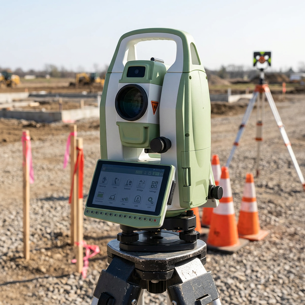
The automatic theodolite's user interface design prioritizes operator efficiency and ease of use, featuring intuitive menu systems and logical workflow organization that reduces learning curves and minimizes operation errors. The instrument's high-resolution color display provides clear visibility of measurement data, menu options, and system status information under various lighting conditions, from bright sunlight to low-light environments. Customizable display layouts allow users to configure screens according to their specific surveying requirements and personal preferences, enhancing productivity through personalized operation modes. The interface incorporates graphical icons and symbols that transcend language barriers, making the instrument accessible to international users and reducing training requirements for multilingual crews. Advanced help systems provide contextual assistance and measurement guidance directly on the instrument display, reducing dependence on printed manuals and external reference materials. The automatic theodolite's data management capabilities extend far beyond simple measurement storage, offering sophisticated file organization systems that categorize measurements by project, date, operator, and custom parameters. Powerful search and filtering functions enable rapid location of specific measurements within large datasets, particularly valuable during quality control reviews and data verification processes. The instrument's ability to export data in multiple industry-standard formats ensures compatibility with popular surveying software packages, CAD systems, and GIS applications. Real-time data validation features perform automatic checks for measurement consistency and geometric closure, alerting operators to potential errors before they propagate through survey calculations. The system's backup and redundancy features protect valuable survey data through multiple storage locations and automatic backup routines that prevent data loss due to equipment failure or operator error. Advanced communication capabilities enable wireless data transfer to field computers, tablets, and cloud-based storage systems, facilitating seamless integration with modern digital workflows and remote collaboration requirements.
Motorized Operation and Remote Control Capabilities

Motorized Operation and Remote Control Capabilities

The automatic theodolite's motorized operation system revolutionizes traditional surveying workflows by enabling precise remote control of telescope positioning and measurement functions, significantly enhancing operator safety and measurement efficiency. The instrument's dual-axis motorization provides smooth, accurate positioning of the telescope to any desired direction with arc-second precision, eliminating the physical effort required for manual telescope movement. Advanced servo motor systems deliver consistent positioning speed and accuracy regardless of environmental conditions, maintaining reliable performance in extreme temperatures and challenging field conditions. The remote control functionality allows operators to position themselves at optimal observation points or safety distances while maintaining full control over instrument operation through wireless handheld controllers or tablet interfaces. This capability proves particularly valuable when working near traffic, hazardous materials, or in confined spaces where direct instrument access presents safety concerns. The motorized system's programmable operation modes enable automated measurement sequences that can execute complex surveying procedures without continuous operator intervention, reducing fatigue and improving consistency in repetitive measurement tasks. Advanced tracking capabilities allow the instrument to follow moving targets automatically, particularly useful for construction layout work and machine guidance applications where continuous positioning updates are required. The system's precise motor control enables micro-positioning adjustments that would be impossible to achieve manually, particularly beneficial when working at maximum magnification or measuring to distant targets. Integration with robotic total station functionality transforms the automatic theodolite into a comprehensive automated surveying system capable of performing layout, monitoring, and measurement tasks with minimal human intervention. The motorized operation system includes sophisticated collision detection and protection mechanisms that prevent damage to the instrument during automated movements, ensuring reliable long-term operation even in demanding field conditions. Battery optimization features manage power consumption intelligently, extending operational time while maintaining full motorized functionality throughout typical surveying workdays.

Get a Free Quote

Our representative will contact you soon.
Email
Name
Company Name
Message
0/1000