Auto Level Survey Instrument - Professional Precision Surveying Equipment for Construction & Engineering

All Categories

auto level survey instrument

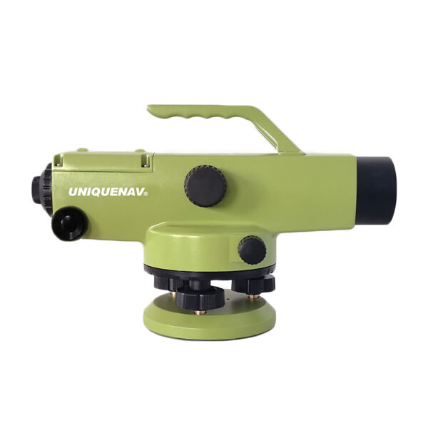
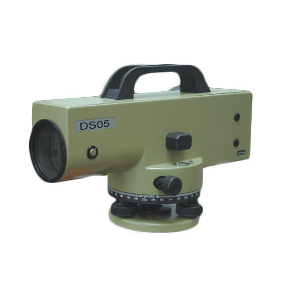
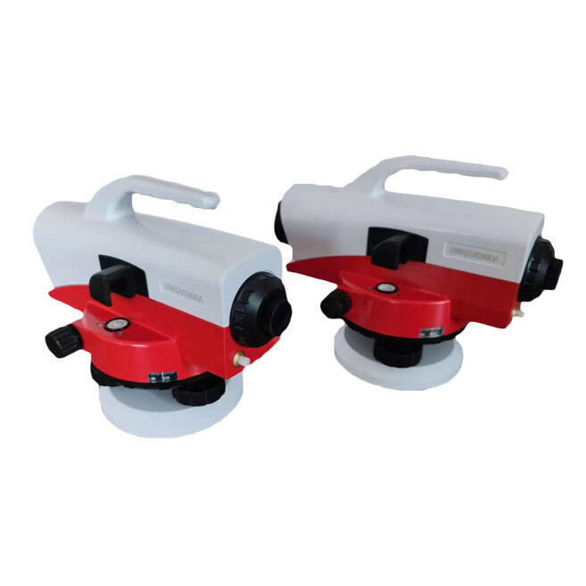
The auto level survey instrument represents a fundamental breakthrough in precision measurement technology, designed to streamline construction and engineering projects through automated horizontal plane establishment. This sophisticated device combines traditional optical principles with modern mechanical engineering to deliver consistent, reliable measurements across diverse terrain conditions. The auto level survey instrument functions as a self-leveling optical instrument that automatically maintains a perfectly horizontal line of sight, eliminating the manual adjustments typically required with conventional surveying equipment. At its core, this instrument utilizes a compensator mechanism that responds to gravity, ensuring the telescope remains level even when the instrument base experiences minor tilting within acceptable parameters. The technological framework incorporates high-grade optical systems featuring multi-coated lenses that enhance light transmission and reduce glare, resulting in crystal-clear target visibility under various lighting conditions. Advanced models of the auto level survey instrument integrate digital readouts, electronic data storage capabilities, and wireless connectivity options that facilitate seamless integration with modern surveying workflows. The instrument's robust construction typically features weatherproof housing, shock-resistant components, and precision-engineered internal mechanisms that maintain accuracy over extended operational periods. Key applications span across construction site preparation, foundation laying, road construction, drainage system installation, landscaping projects, and architectural surveys. The auto level survey instrument proves indispensable for establishing reference points, determining elevation differences, creating topographical maps, and ensuring structural elements maintain proper alignment throughout construction phases. Professional surveyors, civil engineers, construction managers, and architects rely on this instrument for projects requiring precise horizontal measurements and elevation control. The device's versatility extends to both large-scale infrastructure projects and smaller residential developments, making it an essential tool for anyone involved in land development, building construction, or site preparation activities where accuracy and efficiency are paramount considerations.

New Product Recommendations

The auto level survey instrument delivers substantial operational advantages that directly translate into cost savings and enhanced productivity for construction and surveying professionals. Unlike manual leveling instruments that require constant adjustment and re-calibration, this automated system maintains precise horizontal alignment independently, reducing setup time by up to seventy percent compared to traditional methods. The self-leveling capability eliminates human error associated with manual bubble adjustments, ensuring consistent accuracy across all measurements regardless of operator experience level. This reliability factor proves especially valuable when working with temporary staff or training new team members, as the auto level survey instrument compensates for inexperience through its automated precision controls. Time efficiency represents another significant advantage, as operators can focus on taking measurements rather than continuously monitoring and adjusting instrument alignment. The enhanced productivity directly impacts project timelines, allowing teams to complete surveying tasks faster and move construction phases forward without delays. Modern auto level survey instruments offer superior durability compared to older mechanical alternatives, featuring reinforced housing that withstands harsh jobsite conditions including dust, moisture, temperature fluctuations, and minor impacts. This ruggedness reduces maintenance requirements and extends instrument lifespan, providing better return on investment over time. The optical quality of contemporary models surpasses previous generations, incorporating anti-reflective coatings and precision lens systems that deliver clearer target images even in challenging lighting conditions. Many units now include digital displays that show measurements directly, eliminating transcription errors and speeding up data recording processes. Wireless connectivity options enable real-time data transfer to tablets, smartphones, or computer systems, streamlining documentation workflows and reducing paperwork. The compact, lightweight design of modern auto level survey instruments enhances portability without sacrificing stability or accuracy, making transportation between jobsites more convenient. Battery life improvements allow for extended field operation, while quick-setup features enable rapid deployment when time constraints are critical. These combined advantages make the auto level survey instrument an indispensable asset for any organization prioritizing efficiency, accuracy, and professional results in their surveying and construction activities.

Latest News

GNSS RTK: The Ultimate Guide to Real-Time Kinematic Surveying

27

Nov

GNSS RTK: The Ultimate Guide to Real-Time Kinematic Surveying

Real-Time Kinematic (RTK) technology has revolutionized the field of surveying by providing centimeter-level accuracy in positioning measurements. This advanced Global Navigation Satellite System (GNSS) technique enables surveyors, construction profe...
View More
How GNSS RTK Systems Deliver High-Precision Results

27

Nov

How GNSS RTK Systems Deliver High-Precision Results

Modern surveying and positioning applications demand exceptional accuracy that traditional GPS systems simply cannot deliver. Global Navigation Satellite System Real-Time Kinematic (GNSS RTK Systems) have revolutionized precision positioning by provi...
View More
Top Tips for Using High Accuracy Handheld GPS in the Field

27

Nov

Top Tips for Using High Accuracy Handheld GPS in the Field

Professional fieldwork demands precision, reliability, and efficiency in positioning technology. Modern surveying, construction, and geospatial applications require positioning solutions that deliver centimeter-level accuracy while maintaining the po...
View More
How Does an Auto Level Improve Site-Leveling Efficiency?

11

Feb

How Does an Auto Level Improve Site-Leveling Efficiency?

Construction and surveying professionals consistently seek tools that enhance precision while reducing time-consuming manual processes. The auto level stands as one of the most crucial instruments in modern site-leveling operations, transforming how ...
View More

Get a Free Quote

Our representative will contact you soon.
Email
Name
Company Name
Message
0/1000

auto level survey instrument

Advanced Self-Leveling Technology for Unmatched Precision

Advanced Self-Leveling Technology for Unmatched Precision

The revolutionary self-leveling technology integrated into the auto level survey instrument represents the pinnacle of surveying precision, utilizing sophisticated pendulum-based compensator systems that automatically maintain perfect horizontal alignment without manual intervention. This cutting-edge mechanism responds instantaneously to gravitational forces, detecting even microscopic deviations from true level and making continuous micro-adjustments to ensure the telescope remains precisely horizontal throughout the entire measurement process. The compensator system operates within a specific working range, typically allowing for initial setup tolerances of several degrees while still achieving final accuracy measurements within millimeter precision standards. This technology eliminates the traditional need for operators to manually adjust bubble levels, significantly reducing the time required for instrument setup and minimizing the potential for human error that can compromise measurement accuracy. The auto level survey instrument's self-leveling capability proves especially valuable when working on uneven terrain or unstable surfaces where maintaining perfect manual leveling would be extremely challenging or impossible. Professional surveyors appreciate how this technology maintains consistency across multiple measurement points, ensuring that elevation readings remain accurate even as environmental conditions change throughout the workday. The compensator mechanism is designed with robust materials and precision engineering that maintains calibration over extended periods, reducing maintenance requirements and providing reliable performance in demanding field conditions. Advanced models incorporate temperature compensation features that account for thermal expansion effects on internal components, further enhancing measurement precision across varying weather conditions. The self-leveling technology also includes safety features that lock the compensator mechanism during transport, protecting delicate internal components from damage caused by vibration or impact. This automated precision capability transforms surveying workflows by allowing operators to focus on data collection rather than instrument maintenance, ultimately increasing productivity while ensuring that every measurement meets professional accuracy standards required for construction and engineering applications.
Exceptional Optical System for Superior Visibility and Accuracy

Exceptional Optical System for Superior Visibility and Accuracy

The advanced optical system incorporated within the auto level survey instrument delivers unparalleled visual clarity and measurement precision through state-of-the-art lens technology and innovative design engineering. This sophisticated optical assembly features multi-element objective lenses with specialized anti-reflective coatings that maximize light transmission while minimizing glare and unwanted reflections, resulting in crisp, clear target images even under challenging lighting conditions such as bright sunlight, overcast skies, or dawn and dusk operations. The telescope magnification capabilities, typically ranging from 20x to 32x power, provide detailed target resolution that enables precise readings at considerable distances while maintaining accuracy standards required for professional surveying applications. The optical system's design incorporates parallax-free reticle positioning that eliminates reading errors caused by eye position variations, ensuring consistent measurements regardless of operator viewing angle or technique. Advanced models feature illuminated reticles with adjustable brightness controls that enhance target visibility during low-light conditions, extending operational hours and improving productivity during early morning or late evening work sessions. The focusing mechanism utilizes smooth, precise adjustment controls that allow operators to achieve sharp target images quickly, reducing eye strain during extended use periods and improving overall measurement accuracy. Internal lens elements are sealed within weatherproof housings that protect against moisture, dust, and temperature fluctuations while maintaining optical clarity throughout the instrument's operational lifespan. The eyepiece design incorporates comfortable rubber guards that provide proper eye positioning and reduce fatigue during prolonged surveying sessions. Many contemporary auto level survey instruments include variable magnification options that allow operators to adjust viewing power based on target distance and measurement requirements, providing flexibility for different project needs. The optical system's construction utilizes premium glass materials and precision manufacturing techniques that ensure dimensional stability and optical performance consistency over time, making the auto level survey instrument a reliable investment for professional surveying applications where visual clarity and measurement accuracy are essential for project success.
Versatile Applications Across Multiple Industries and Project Types

Versatile Applications Across Multiple Industries and Project Types

The auto level survey instrument demonstrates remarkable versatility through its broad application spectrum, serving as an essential tool across numerous industries and project types where precise horizontal measurements and elevation control are critical for successful outcomes. Construction professionals rely heavily on this instrument for foundation preparation, ensuring building footings maintain proper elevation relationships and preventing costly structural problems that could arise from improper grading or leveling errors. Road construction teams utilize the auto level survey instrument to establish proper drainage gradients, verify pavement thickness specifications, and ensure roadway surfaces meet engineering design requirements for safety and longevity. Landscaping contractors depend on this technology for creating precise grading plans, installing irrigation systems with appropriate slopes for water flow, and establishing proper drainage patterns that prevent erosion and water damage issues. Architectural firms incorporate auto level survey instrument data into building design processes, using elevation measurements to optimize building placement, plan accessibility features, and ensure compliance with local building codes and zoning requirements. Municipal engineering departments utilize these instruments for infrastructure maintenance, storm water management system installation, and public works projects that require precise elevation control for proper function and safety. Pipeline installation contractors rely on auto level survey instrument accuracy to maintain proper slopes for gravity-fed systems, ensure adequate pipe depth for frost protection, and verify installation specifications meet regulatory requirements. Agricultural applications include land leveling for irrigation efficiency, terracing projects for erosion control, and drainage system installation to improve crop production capabilities. Mining operations use these instruments for site preparation, haul road construction, and facility placement where precise elevation control impacts operational safety and efficiency. Environmental restoration projects depend on auto level survey instrument measurements for establishing proper grades that support natural water flow patterns and wildlife habitat requirements. The instrument's portability and ease of use make it equally valuable for small residential projects and large commercial developments, providing professional-grade accuracy that ensures project specifications are met consistently. This versatility, combined with the instrument's reliability and precision capabilities, makes the auto level survey instrument an indispensable tool for any organization involved in construction, engineering, or land development activities.

Get a Free Quote

Our representative will contact you soon.
Email
Name
Company Name
Message
0/1000