Professional RTK Survey Equipment: High-Precision Positioning Solutions for Modern Surveying

All Categories

rtk survey equipment

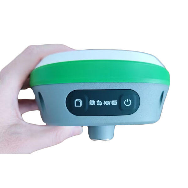
RTK survey equipment represents a revolutionary advancement in precision positioning technology, combining Global Navigation Satellite System (GNSS) capabilities with real-time corrections for unprecedented accuracy. This sophisticated system consists of a base station, rover units, and advanced communication links that work in perfect synchronization. The base station, positioned at a known point, transmits correction data to mobile rover units, enabling centimeter-level accuracy in real-time positioning. Modern RTK survey equipment features integrated cellular or radio communication modules, ensuring seamless data transmission between components. These systems typically include high-resolution displays, intuitive user interfaces, and robust data collection software that streamlines the survey process. The equipment's versatility allows for rapid data collection across various applications, including construction layout, topographic mapping, and precision agriculture. Advanced RTK systems incorporate multiple satellite constellation support, including GPS, GLONASS, Galileo, and BeiDou, maximizing satellite availability and accuracy. The equipment's durability is engineered to withstand harsh environmental conditions, featuring water-resistant housings and shock-resistant components. With battery life typically extending beyond 8 hours of continuous operation, these systems ensure uninterrupted field work capability.

New Product Recommendations

RTK survey equipment offers numerous compelling advantages that make it an indispensable tool for modern surveying and positioning applications. First, its real-time processing capability eliminates the need for post-processing, enabling immediate decision-making in the field and significantly reducing project timelines. The centimeter-level accuracy achieved by RTK systems dramatically improves the quality and reliability of survey data, minimizing errors and potential rework. These systems show remarkable versatility, supporting multiple survey methods and applications within a single platform. The equipment's user-friendly interface reduces the learning curve for new operators, while advanced features satisfy the needs of experienced professionals. Cost-effectiveness is achieved through increased productivity, as RTK systems can complete surveys faster than traditional methods, requiring fewer staff hours and resources. The integration of wireless technology enables seamless data transfer to office software, streamlining workflow and reducing administrative overhead. Modern RTK equipment's multi-constellation support ensures reliable performance even in challenging environments with limited satellite visibility. The systems robust design and durability translate to lower maintenance costs and extended service life. Additionally, the equipment's compatibility with various data formats and third-party software enhances its value as a long-term investment. The ability to store and export data in multiple formats facilitates collaboration and integration with existing workflows. Real-time quality control features help operators identify and address issues immediately, ensuring data integrity and reducing the need for return visits to survey sites.

Latest News

What are the common error sources in GNSS RTK positioning and how to mitigate them?

21

Mar

What are the common error sources in GNSS RTK positioning and how to mitigate them?

View More
What are the key differences between GNSS RTK and PPP?

25

Mar

What are the key differences between GNSS RTK and PPP?

View More
What are the common error sources and solutions when using RTK GNSS?

22

Apr

What are the common error sources and solutions when using RTK GNSS?

View More
Laser RTK vs GNSS: Which One Is Better?

22

Apr

Laser RTK vs GNSS: Which One Is Better?

View More

Get a Free Quote

Our representative will contact you soon.
Email
Name
Company Name
Message
0/1000

rtk survey equipment

Advanced Positioning Technology

Advanced Positioning Technology

The cornerstone of RTK survey equipment lies in its advanced positioning technology, which represents a significant leap forward in surveying capabilities. The system employs sophisticated algorithms that process carrier phase measurements from satellite signals, enabling centimeter-level positioning accuracy in real-time. This technology integrates multiple GNSS constellations, providing robust performance even in challenging environments. The equipment's ability to track and process signals from various satellite systems simultaneously ensures optimal coverage and reliability. Advanced error correction mechanisms compensate for atmospheric effects, multipath interference, and other potential sources of positioning errors. The system's rapid initialization time, typically under 30 seconds, allows for quick setup and efficient field operations. This technology also includes automatic base-rover coordination, ensuring seamless communication and data synchronization between system components.
Comprehensive Data Management

Comprehensive Data Management

RTK survey equipment excels in comprehensive data management capabilities, offering a complete solution for collecting, processing, and storing survey data. The system features advanced data logging functionality that automatically records all necessary information, including position coordinates, time stamps, and quality indicators. Built-in quality control mechanisms continuously monitor measurement reliability and alert operators to potential issues. The equipment supports various data formats and includes powerful export options for seamless integration with CAD, GIS, and other professional software packages. Cloud connectivity enables real-time data backup and sharing, ensuring data security and facilitating collaboration among team members. The system's intelligent memory management optimizes storage usage while maintaining data integrity throughout extended survey operations.
Field-Optimized Design

Field-Optimized Design

The field-optimized design of RTK survey equipment demonstrates a perfect balance between durability and functionality. Built to withstand demanding environmental conditions, the equipment features IP67-rated waterproof and dustproof housing, ensuring reliable operation in adverse weather conditions. The ergonomic design prioritizes user comfort during extended field sessions, with carefully positioned controls and balanced weight distribution. High-capacity batteries provide all-day operation, while hot-swap capability ensures uninterrupted workflow. The equipment's bright, sunlight-readable display maintains visibility in all lighting conditions, while the intuitive interface minimizes operational complexity. Robust mounting systems and quick-release mechanisms facilitate rapid setup and breakdown, maximizing field efficiency. The equipment's modular design allows for easy maintenance and upgrades, protecting the investment value over time.