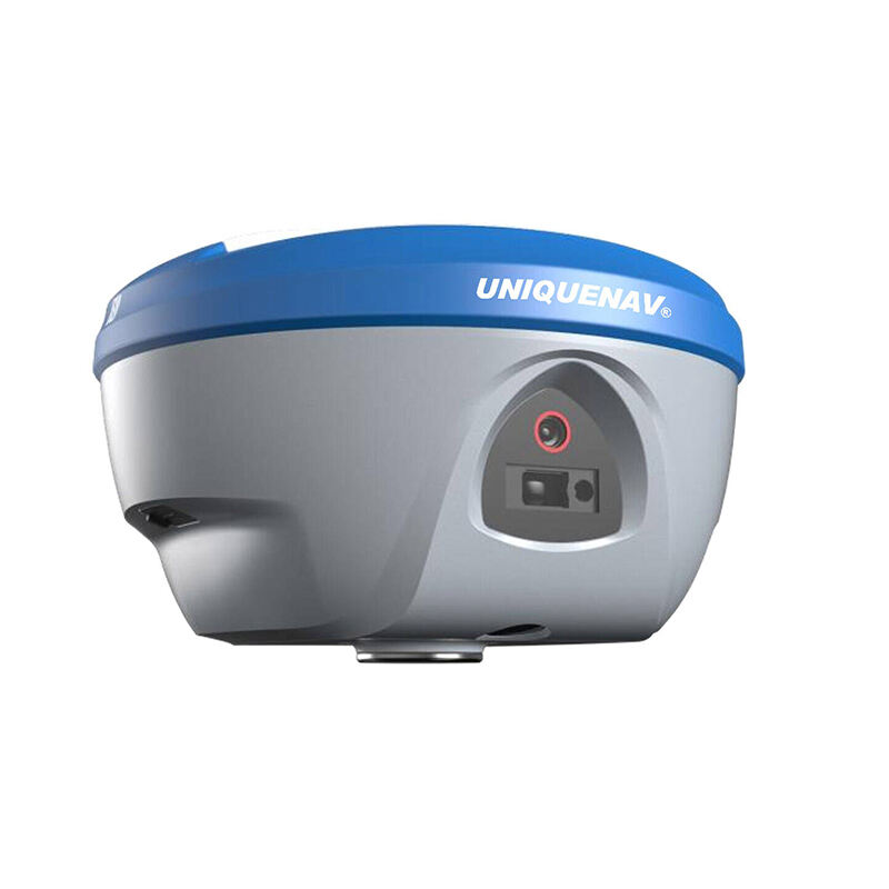
High-Precision RTK GPS Module: Centimeter-Level Accuracy for Professional Applications

All Categories

rtk gps module

The RTK GPS module represents a significant advancement in precision positioning technology, offering centimeter-level accuracy for various applications. This sophisticated system utilizes Real-Time Kinematic positioning, which enhances standard GPS capabilities by comparing data from a base station with a rover unit. The module processes carrier phase measurements and corrects atmospheric errors in real-time, achieving positioning accuracy of up to 1-2 centimeters horizontally and 3-5 centimeters vertically. The system consists of two main components: a base station that remains at a known fixed position and a rover that moves with the user or vehicle. Through continuous communication between these components, the RTK GPS module can provide precise positioning data at update rates of up to 20Hz. The technology incorporates multiple satellite constellation support, including GPS, GLONASS, and BeiDou, ensuring robust performance and reliability across different geographical locations. Advanced error correction algorithms and multi-frequency capabilities enable the module to maintain accuracy even in challenging environments. The system's ability to process complex positioning calculations in real-time makes it invaluable for applications requiring precise navigation and positioning data.

New Product Recommendations

The RTK GPS module offers numerous compelling advantages that make it an essential tool for precision applications. First and foremost, its centimeter-level accuracy represents a massive improvement over standard GPS systems, enabling users to achieve previously impossible levels of positioning precision. This enhanced accuracy proves particularly valuable in agriculture, where precise field mapping and automated guidance systems can significantly improve crop management and resource utilization. The module's real-time processing capabilities ensure immediate access to accurate positioning data, eliminating the need for post-processing and enabling instant decision-making. The system's multi-constellation support provides superior reliability and coverage, ensuring consistent performance even in challenging environments or when certain satellite signals are obstructed. The module's high update rate of up to 20Hz enables smooth tracking of rapid movements, making it ideal for dynamic applications such as drone navigation and machine control. The technology's ability to maintain accuracy across large operating ranges, typically up to 10 kilometers from the base station, provides flexibility for various applications. Additionally, the system's robust error correction capabilities help maintain accuracy even in the presence of atmospheric interference or multipath effects. The module's low power consumption and compact design make it suitable for integration into various devices and systems, while its standardized communication protocols ensure compatibility with different platforms and applications.

Latest News

How to Set Up and Calibrate an Android Total Station?

21

Mar

How to Set Up and Calibrate an Android Total Station?

View More
What are the key differences between GNSS RTK and PPP?

25

Mar

What are the key differences between GNSS RTK and PPP?

View More
How to choose the right RTK GNSS equipment?

22

Apr

How to choose the right RTK GNSS equipment?

View More
What are the common error sources and solutions when using RTK GNSS?

22

Apr

What are the common error sources and solutions when using RTK GNSS?

View More

Get a Free Quote

Our representative will contact you soon.
Email
Name
Company Name
Message
0/1000

rtk gps module

Advanced Multi-Constellation Support

Advanced Multi-Constellation Support

The RTK GPS module's multi-constellation support represents a significant technological advancement in precision positioning. By simultaneously tracking signals from multiple satellite systems including GPS, GLONASS, BeiDou, and Galileo, the module ensures optimal satellite geometry and signal availability. This comprehensive coverage significantly improves positioning reliability and accuracy, particularly in challenging environments where obstacles might block certain satellite signals. The system's ability to process multiple frequency bands from different constellations also enhances its resistance to ionospheric errors and multipath effects. This feature enables the module to maintain centimeter-level accuracy even in urban canyons or areas with partial sky visibility, where traditional GPS systems might struggle to maintain reliable positioning.
Real-Time Processing and High Update Rate

Real-Time Processing and High Update Rate

The module's real-time processing capabilities and high update rate set it apart from conventional positioning systems. With the ability to process complex RTK calculations and provide position updates at rates up to 20Hz, the system delivers precise positioning information with minimal latency. This rapid processing and update capability is crucial for applications requiring immediate positioning feedback, such as autonomous vehicle navigation and precision agriculture. The system's ability to maintain high accuracy while processing data in real-time enables dynamic applications that would be impossible with traditional post-processed positioning systems. The high update rate ensures smooth tracking of moving objects and enables precise trajectory mapping, making it ideal for applications requiring continuous position monitoring.
Exceptional Error Correction and Reliability

Exceptional Error Correction and Reliability

The RTK GPS module incorporates sophisticated error correction algorithms that significantly enhance its reliability and accuracy. These algorithms process and correct various error sources, including atmospheric delays, multipath effects, and satellite orbit errors, ensuring consistent centimeter-level accuracy. The system's ability to maintain fixed RTK solutions over extended periods demonstrates its exceptional stability and reliability. Advanced error modeling techniques and real-time correction capabilities enable the module to adapt to changing environmental conditions and maintain accuracy even in challenging scenarios. This robust error correction framework, combined with the module's multi-constellation support, creates a highly reliable positioning solution suitable for critical applications where accuracy and dependability are essential.