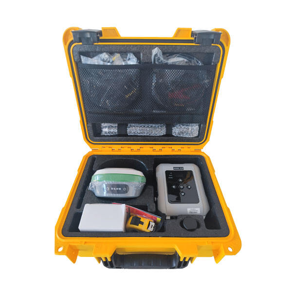
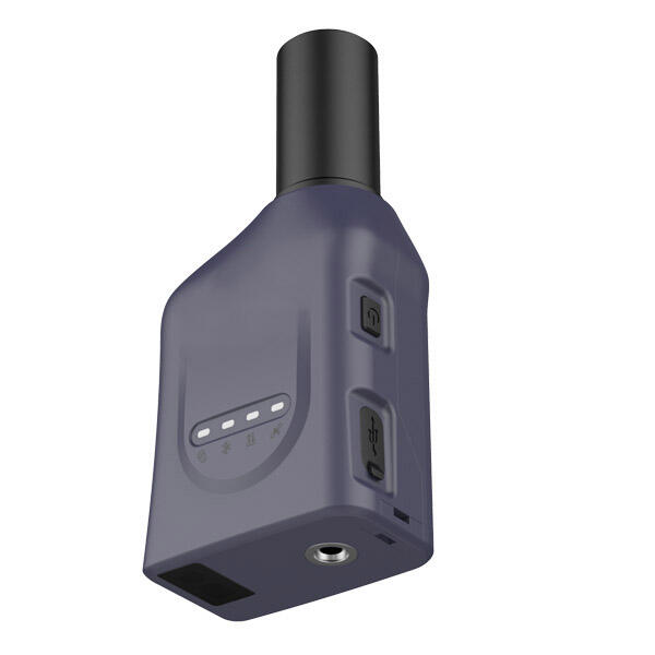
Professional Handheld RTK GPS | Centimeter-Accurate Positioning Solution

All Categories

handheld rtk gps

The handheld RTK GPS represents a significant advancement in precision positioning technology, combining the accuracy of Real-Time Kinematic positioning with the convenience of a portable device. This sophisticated instrument provides centimeter-level accuracy in real-time, making it an invaluable tool for various professional applications. The system works by utilizing both GPS signals and correction data from base stations to achieve high-precision positioning. Modern handheld RTK GPS units feature intuitive touchscreen interfaces, robust data collection capabilities, and extended battery life for full-day operations. They are equipped with advanced satellite tracking systems that can receive signals from multiple GNSS constellations, including GPS, GLONASS, Galileo, and BeiDou, ensuring reliable positioning even in challenging environments. The devices typically include built-in cellular modems for receiving RTK corrections, Bluetooth connectivity for external sensors, and USB ports for data transfer. Many units are designed with rugged construction, meeting IP67 standards for water and dust resistance, making them suitable for use in harsh field conditions. The integration of sophisticated software allows for real-time data processing, mapping, and stake-out functions, while internal storage capabilities enable the recording of thousands of points and detailed attribute information.

Popular Products

Handheld RTK GPS systems offer numerous compelling advantages that make them essential tools for modern surveying and mapping operations. The primary benefit is their ability to deliver centimeter-level accuracy in real-time, eliminating the need for post-processing and enabling immediate decision-making in the field. This instant accuracy verification significantly reduces the need for return visits to project sites, saving both time and operational costs. The portable nature of these devices allows for unprecedented mobility and flexibility, enabling surveyors to access challenging terrain and confined spaces that would be difficult with traditional survey equipment. The integration of multiple satellite constellations enhances reliability and accuracy, particularly in areas with partial sky visibility or urban canyons. Modern handheld RTK GPS units feature user-friendly interfaces that reduce the learning curve and training requirements, making them accessible to professionals across various industries. The devices support multiple data collection workflows and can seamlessly integrate with existing GIS and CAD systems, streamlining the data management process. Their robust construction ensures reliability in demanding field conditions, while long battery life supports full workday operations without interruption. The ability to collect and store detailed attribute information along with spatial data enhances the value of collected data for analysis and decision-making. Advanced connectivity options facilitate real-time data sharing and collaboration between field teams and office personnel, improving project coordination and efficiency. The cost-effectiveness of these systems, compared to traditional survey equipment, makes high-precision positioning accessible to a broader range of professionals and organizations.

Latest News

What Are the Benefits of Using an Android Total Station?

21

Mar

What Are the Benefits of Using an Android Total Station?

View More
What are the common error sources in GNSS RTK positioning and how to mitigate them?

21

Mar

What are the common error sources in GNSS RTK positioning and how to mitigate them?

View More
How to choose the right RTK GNSS equipment?

22

Apr

How to choose the right RTK GNSS equipment?

View More
Laser RTK vs GNSS: Which One Is Better?

22

Apr

Laser RTK vs GNSS: Which One Is Better?

View More

Get a Free Quote

Our representative will contact you soon.
Email
Name
Company Name
Message
0/1000

handheld rtk gps

Advanced Positioning Technology

Advanced Positioning Technology

The handheld RTK GPS incorporates state-of-the-art positioning technology that sets new standards for accuracy and reliability in portable navigation devices. At its core, the system utilizes sophisticated Real-Time Kinematic algorithms that process carrier phase measurements from multiple satellite constellations simultaneously. This multi-constellation capability ensures optimal satellite geometry and redundancy, resulting in more reliable position solutions even in challenging environments. The system's advanced error modeling and correction capabilities account for various sources of positioning errors, including atmospheric effects, multipath interference, and satellite orbit uncertainties. The integration of high-sensitivity GNSS receivers enables tracking of weak satellite signals, while advanced multipath mitigation techniques reduce the impact of reflected signals in urban environments. The system's ability to maintain centimeter-level accuracy in real-time represents a significant technological achievement that transforms how positioning tasks are performed in numerous professional applications.
Robust Field Performance

Robust Field Performance

The handheld RTK GPS is engineered to deliver exceptional performance under demanding field conditions. The device's rugged construction meets military-grade standards for durability, featuring reinforced housing that protects against drops, shocks, and vibrations. The IP67 rating ensures complete protection against dust ingress and water immersion up to 1 meter, enabling operation in various weather conditions. The high-capacity battery system utilizes smart power management technology to provide extended operation times, while hot-swappable batteries enable continuous operation during long field sessions. The sunlight-readable display maintains visibility in bright outdoor conditions, while the responsive touch interface remains functional even when wet or when used with gloves. The device's ergonomic design reduces user fatigue during extended use, and strategically placed physical buttons enable quick access to essential functions.
Versatile Data Management

Versatile Data Management

The handheld RTK GPS excels in comprehensive data management capabilities that streamline field operations and enhance productivity. The system features an intuitive data collection interface that supports customizable attribute forms, enabling detailed feature documentation beyond basic positioning information. The onboard storage system can handle large datasets, including high-resolution background maps and imagery, while maintaining fast access speeds. Advanced data filtering and quality control mechanisms ensure the integrity of collected information, with real-time validation of measurements against predefined accuracy thresholds. The device supports multiple data export formats, facilitating seamless integration with various GIS, CAD, and asset management systems. Cloud connectivity enables real-time data synchronization with office servers, ensuring that project stakeholders have immediate access to field updates and reducing the risk of data loss.