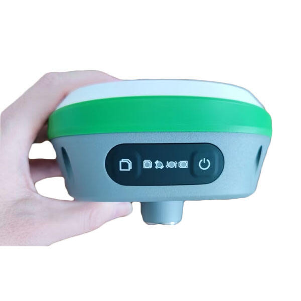
Professional GNSS RTK Rover: High-Precision Positioning Solution for Surveying and Mapping

All Categories

gnss rtk rover

The GNSS RTK rover represents a cutting-edge surveying and positioning technology that combines Global Navigation Satellite System capabilities with Real-Time Kinematic corrections to deliver centimeter-level accuracy. This sophisticated device integrates multiple satellite constellations including GPS, GLONASS, Galileo, and BeiDou to ensure comprehensive coverage and reliable positioning data. The system consists of a mobile receiver unit, advanced antenna technology, and powerful processing software that work in tandem to provide precise location information in real-time. Operating on both L1 and L2 frequency bands, the GNSS RTK rover can effectively minimize signal errors and maintain accuracy even in challenging environments. The device features built-in wireless communication capabilities, allowing it to receive correction data from base stations or network RTK services. Modern GNSS RTK rovers are designed with user-friendly interfaces, rechargeable batteries that support full-day operations, and rugged construction to withstand various weather conditions. These devices find extensive applications in land surveying, precision agriculture, construction layout, GIS data collection, and infrastructure monitoring projects.
New Product Releases

The GNSS RTK rover offers numerous compelling advantages that make it an invaluable tool for professionals across various industries. First and foremost, its ability to provide centimeter-level accuracy in real-time dramatically improves workflow efficiency, eliminating the need for post-processing in most applications. The multi-constellation support ensures reliable positioning even in areas with partial satellite visibility, such as urban canyons or under tree canopy. Users benefit from rapid initialization times, typically under 30 seconds, which significantly reduces setup time on job sites. The integration of modern wireless technologies enables seamless connection to correction services, eliminating the need for local base stations in many scenarios. The rover's advanced power management systems provide extended operation times, while smart data management features allow for easy export and integration with various software platforms. The rugged design ensures reliability in harsh environmental conditions, reducing downtime and maintenance costs. The user-friendly interface minimizes training requirements, allowing even less experienced operators to achieve professional results. Additionally, the device's versatility enables its use across multiple applications, providing excellent return on investment. The built-in quality control mechanisms help users maintain high accuracy standards by monitoring satellite geometry and signal quality. These advantages combine to create a powerful tool that enhances productivity, reduces operational costs, and improves the overall quality of surveying and positioning work.

Practical Tips

How to Set Up and Calibrate an Android Total Station?

21

Mar

How to Set Up and Calibrate an Android Total Station?

View More
What Are the Benefits of Using an Android Total Station?

21

Mar

What Are the Benefits of Using an Android Total Station?

View More
What are the common error sources and solutions when using RTK GNSS?

22

Apr

What are the common error sources and solutions when using RTK GNSS?

View More
Laser RTK vs GNSS: Which One Is Better?

22

Apr

Laser RTK vs GNSS: Which One Is Better?

View More

Get a Free Quote

Our representative will contact you soon.
Email
Name
Company Name
Message
0/1000

gnss rtk rover

Advanced Positioning Technology

Advanced Positioning Technology

The GNSS RTK rover employs state-of-the-art positioning technology that sets new standards in surveying accuracy and reliability. At its core, the system utilizes advanced signal processing algorithms that simultaneously track multiple satellite constellations, providing redundant measurements that enhance accuracy and reliability. The rover's sophisticated RTK engine processes carrier phase measurements in real-time, enabling centimeter-level positioning accuracy. The inclusion of multiple frequency support allows for better ionospheric error correction and improved performance under challenging conditions. The system's advanced multipath mitigation techniques effectively reduce signal reflection errors, ensuring consistent accuracy even in environments with potential interference sources. This technological foundation enables professionals to conduct high-precision surveys with unprecedented efficiency and confidence.
Robust Field Performance

Robust Field Performance

The GNSS RTK rover is engineered to deliver exceptional performance in demanding field conditions. The device features military-grade construction with IP67 rating, ensuring protection against dust and water immersion. The integrated shock-resistant design protects sensitive internal components from impacts and vibrations commonly encountered in field operations. The high-sensitivity antenna design maintains reliable satellite tracking even under dense canopy or in urban environments with limited sky visibility. Extended battery life supports full workday operations without the need for recharging, while hot-swappable batteries enable continuous operation for extended projects. The system's rapid initialization capability minimizes downtime during point collection, while built-in tilt compensation allows for accurate measurements even when the pole is not perfectly plumb.
Comprehensive Connectivity Solutions

Comprehensive Connectivity Solutions

The GNSS RTK rover features extensive connectivity options that enhance its versatility and ease of use in various working environments. The device incorporates multiple wireless communication protocols, including 4G LTE, Wi-Fi, and Bluetooth, ensuring reliable data transfer and correction reception regardless of location. The built-in cellular modem enables seamless connection to NTRIP correction services, eliminating the need for separate radio links in many applications. The integrated web interface allows for remote configuration and monitoring, streamlining field operations and troubleshooting. Advanced data management features support various industry-standard formats, facilitating easy integration with existing workflow solutions. The system's real-time data sync capabilities ensure that collected data is immediately available for office processing, improving project coordination and efficiency.