Digital Theodolite - Advanced Electronic Surveying Instrument for Precision Angle Measurement

All Categories

digital theodolite

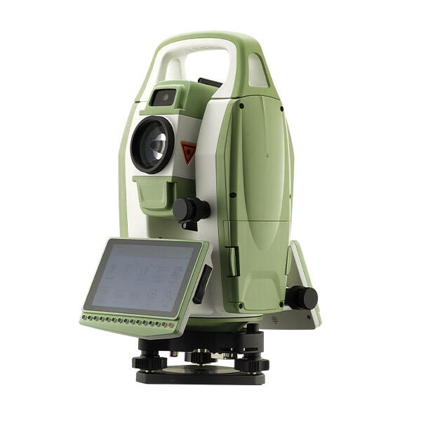
The digital theodolite represents a significant advancement in surveying and construction technology, transforming how professionals measure angles and distances in the field. This sophisticated instrument combines traditional optical theodolite capabilities with modern digital technology to deliver precise angular measurements for horizontal and vertical angles. Unlike conventional theodolites that rely on manual reading of graduated circles, the digital theodolite incorporates electronic sensors and digital displays that provide instant, accurate readings with minimal human error. The instrument features advanced optics with high magnification telescopes, typically ranging from 26x to 32x, enabling surveyors to target distant objects with exceptional clarity. Modern digital theodolites integrate laser plummet systems for precise centering over survey points, eliminating the need for traditional plumb bobs and reducing setup time significantly. The core functionality revolves around measuring horizontal angles between reference points and vertical angles from the horizon, essential for triangulation surveys, topographic mapping, and construction layout work. These instruments utilize absolute encoders that maintain angle readings even after power cycles, ensuring consistent measurements throughout extended survey sessions. The digital display shows measurements in various formats including degrees, minutes, seconds, or decimal degrees, accommodating different professional preferences and project requirements. Many models feature dual-axis compensators that automatically correct for minor instrument tilting, maintaining accuracy even when the theodolite is not perfectly level. Data storage capabilities allow surveyors to record measurements directly in the instrument's memory, reducing transcription errors and streamlining data collection processes. Communication interfaces such as RS-232 or USB ports enable seamless data transfer to computers and survey software, facilitating efficient project documentation and analysis. The rugged construction of digital theodolites ensures reliable performance in challenging environmental conditions, with weather sealing protecting sensitive electronic components from dust and moisture.

New Product Recommendations

Digital theodolites offer remarkable time savings compared to traditional surveying methods, allowing surveyors to complete projects faster and more efficiently. The instant digital readouts eliminate the need for manual interpretation of graduated scales, reducing measurement time from minutes to seconds per reading. This efficiency translates directly into cost savings for surveying firms and construction companies, enabling them to handle more projects with existing staff resources. The enhanced accuracy of digital theodolites significantly reduces measurement errors that can lead to costly construction mistakes and project delays. Electronic angle measurement systems provide precision typically within 2 to 5 arc seconds, far exceeding the capabilities of manual theodolites and ensuring survey data meets the strictest professional standards. The automatic error correction features built into digital theodolites compensate for common sources of measurement error, including instrument tilt and atmospheric refraction effects. Data recording capabilities eliminate transcription errors that frequently occur when manually copying readings from analog instruments into field books. Surveyors can store hundreds or thousands of measurements directly in the instrument's memory, creating a reliable digital record of all survey data. The user-friendly interface design makes digital theodolites accessible to operators with varying experience levels, reducing training time and minimizing the learning curve for new team members. Integrated calculation functions allow surveyors to perform coordinate geometry calculations directly in the field, eliminating the need for separate calculators and reducing computational errors. The robust construction of digital theodolites ensures long-term reliability and lower maintenance costs compared to mechanical instruments with moving parts that wear over time. Weather resistance features protect the investment by allowing operation in adverse conditions that would damage traditional surveying equipment. Remote measurement capabilities enable surveyors to work safely from hazardous locations while maintaining measurement accuracy. The consistent performance of digital theodolites reduces the need for frequent calibration checks, saving both time and money on maintenance procedures. Battery life improvements in modern digital theodolites support full-day operation without interruption, eliminating productivity losses from power management issues. The compatibility with modern survey software and GPS systems creates integrated workflows that streamline the entire surveying process from field measurement to final deliverables.

Tips And Tricks

Why Do Mapping Teams Prefer RTK for Real-Time Positioning Tasks?

22

Dec

Why Do Mapping Teams Prefer RTK for Real-Time Positioning Tasks?

Modern mapping teams face unprecedented demands for precision and speed in their surveying operations. The evolution of positioning technologies has revolutionized how professionals approach field data collection, with RTK for real-time positioning e...
View More
How Does a Digital Level Improve Accuracy in Construction Measurements?

13

Jan

How Does a Digital Level Improve Accuracy in Construction Measurements?

Construction professionals understand that precision forms the foundation of every successful project. Modern building techniques demand measurement accuracy that surpasses traditional methods, making the digital level an indispensable tool for contr...
View More
How Does RTK GPS Reduce Errors in Professional Survey Work?

13

Jan

How Does RTK GPS Reduce Errors in Professional Survey Work?

Professional surveying demands precision that can make the difference between project success and costly mistakes. Traditional GPS systems, while revolutionary, often fall short of the accuracy requirements needed for construction, engineering, and l...
View More
How Does a Theodolite Compare to Total Stations in Practical Use?

11

Feb

How Does a Theodolite Compare to Total Stations in Practical Use?

Surveying professionals and construction engineers face critical decisions when selecting measurement instruments for their projects. The choice between traditional surveying tools and modern integrated systems can significantly impact project effici...
View More

Get a Free Quote

Our representative will contact you soon.
Email
Name
Company Name
Message
0/1000

digital theodolite

Advanced Electronic Measurement System

Advanced Electronic Measurement System

The electronic measurement system in digital theodolites represents the pinnacle of precision surveying technology, delivering unparalleled accuracy and reliability for professional applications. This sophisticated system employs high-resolution encoders that convert mechanical rotation into precise digital angle measurements, eliminating the subjective interpretation required with traditional optical scales. The absolute encoding technology ensures that angle readings remain accurate and consistent even after power interruptions, providing surveyors with confidence in their measurement data throughout long survey sessions. The electronic system incorporates advanced signal processing algorithms that filter out environmental interference and mechanical vibrations, maintaining measurement stability in challenging field conditions. Modern digital theodolites feature dual-axis compensators that continuously monitor instrument tilt and automatically apply corrections to both horizontal and vertical angle measurements, ensuring accuracy even when the instrument is not perfectly leveled. The measurement resolution typically reaches 1 arc second or better, providing the precision required for demanding engineering surveys, property boundary determinations, and construction layout projects. The electronic display systems present measurements in multiple formats simultaneously, allowing surveyors to work with degrees-minutes-seconds, decimal degrees, or grads depending on project requirements and personal preferences. Automatic averaging functions enable multiple measurements of the same angle to be combined statistically, improving overall measurement quality and reducing random errors. The electronic measurement system includes built-in quality control features that alert operators to potential measurement problems, such as excessive instrument movement or environmental interference. Temperature compensation algorithms adjust measurements for thermal expansion effects in the instrument, maintaining accuracy across varying environmental conditions. The rapid measurement cycle time of electronic systems allows surveyors to capture multiple readings quickly, enabling statistical analysis of measurement quality and improving overall survey reliability. Integration with onboard calculation software permits real-time coordinate computation and traverse adjustments, allowing surveyors to verify measurement quality and detect errors immediately in the field.
Comprehensive Data Management and Connectivity

Comprehensive Data Management and Connectivity

Digital theodolites excel in data management and connectivity features that revolutionize survey workflow efficiency and accuracy. The comprehensive data storage capabilities allow surveyors to record and organize thousands of measurements with associated point identifiers, descriptions, and metadata directly within the instrument. Advanced file management systems enable the creation of multiple job files, allowing surveyors to work on different projects simultaneously while maintaining complete data separation and organization. The internal memory systems utilize non-volatile storage technology that preserves survey data even during extended power outages or battery changes, eliminating the risk of data loss that plagued earlier electronic instruments. Flexible data export options support industry-standard formats including ASCII text files, comma-separated values, and specialized survey data formats compatible with major surveying and engineering software packages. Real-time data transfer capabilities through wireless Bluetooth connections enable immediate synchronization with field computers and mobile devices, streamlining data processing and reducing office time requirements. USB connectivity provides high-speed data transfer and instrument configuration options, allowing surveyors to quickly download survey data and upload custom measurement routines or coordinate systems. The integrated coordinate geometry calculation functions perform complex mathematical operations within the instrument, including traverse computations, intersection calculations, and coordinate transformations between different reference systems. Custom measurement programs can be loaded into the digital theodolite to automate repetitive survey procedures, reducing operator workload and minimizing the potential for procedural errors. The data review and editing capabilities allow surveyors to examine and modify measurements directly on the instrument display, correcting minor errors without returning to measured points. Advanced search and filtering functions help surveyors quickly locate specific measurements within large datasets, improving field productivity and data verification processes. The measurement statistics and quality indicators provide real-time feedback on survey accuracy, enabling surveyors to make informed decisions about remeasurement requirements and survey closure tolerances.
Rugged Design and Environmental Adaptability

Rugged Design and Environmental Adaptability

The rugged design and environmental adaptability of digital theodolites ensure reliable performance across diverse working conditions encountered in professional surveying and construction applications. The robust mechanical construction incorporates precision-machined aluminum housings with advanced weather sealing systems that protect sensitive electronic components from dust, moisture, and temperature extremes. The instrument design meets or exceeds international environmental standards for surveying equipment, including IP65 or IP66 ingress protection ratings that guarantee operation in heavy rain and dusty conditions. Advanced materials and surface treatments resist corrosion from salt air and industrial pollutants, extending instrument life in coastal and urban environments. The shock-resistant design protects the delicate optical and electronic systems from impacts and vibrations commonly encountered during transport and field use, reducing maintenance requirements and ensuring consistent measurement accuracy over time. Temperature compensation systems automatically adjust for thermal expansion effects in both the mechanical structure and electronic components, maintaining measurement precision across operating temperature ranges from -20°C to +50°C. The ergonomic design considerations reduce operator fatigue during extended survey sessions, with balanced weight distribution and comfortable control placement that enable efficient operation throughout long working days. High-contrast displays with adjustable backlighting ensure excellent visibility in varying lighting conditions, from bright sunlight to low-light environments typical of indoor construction surveys. The battery management system optimizes power consumption while providing extended operating time, typically supporting 8-12 hours of continuous use on a single charge with intelligent power-saving modes during idle periods. Quick-change battery systems allow surveyors to swap power sources without interrupting survey work, maintaining productivity during extended field sessions. The stable tripod mounting system incorporates precision bearing surfaces and locking mechanisms that maintain instrument orientation and prevent measurement drift during operation. Advanced vibration damping systems minimize the effects of wind and ground vibrations on measurement stability, enabling accurate readings in challenging environmental conditions. The modular design facilitates field maintenance and component replacement, reducing downtime and repair costs while extending overall instrument service life through user-replaceable parts and accessories.

Get a Free Quote

Our representative will contact you soon.
Email
Name
Company Name
Message
0/1000