When professionals depend on precise location data in the field, the performance of a high accuracy handheld GPS device can make or break an entire project. Whether you are working in land surveying, agriculture, construction, or environmental monitoring, understanding what drives positioning precision is essential. Not all handheld GNSS receivers are created equal, and even the best hardware can underperform if the surrounding conditions and operational factors are not properly considered.
A high accuracy handheld GPS device is expected to deliver centimeter- or sub-meter-level positioning in demanding environments. To reliably achieve that level of precision, users and procurement teams need to understand the technical, environmental, and operational factors that influence performance. This article breaks down those key factors clearly and practically, so you can make informed decisions and get the most out of your field equipment.
Satellite Signal Quality and Constellation Coverage
Multi-Constellation Reception
One of the most foundational factors affecting a high accuracy handheld GPS unit is its ability to receive signals from multiple satellite constellations. Modern devices that support GPS, GLONASS, BeiDou, Galileo, and QZSS simultaneously benefit from a much larger pool of visible satellites at any given moment. A broader constellation coverage means more geometry options for the receiver to compute a stronger positional fix.
The more satellite signals a device can track concurrently, the more resilient it becomes against temporary signal dropouts. In environments where certain parts of the sky are obstructed, a multi-constellation high accuracy handheld GPS receiver can compensate by leaning on alternative satellites. This directly contributes to positional stability and reliability across diverse terrain types.
Devices that support only a single constellation, such as GPS alone, are inherently limited in both coverage depth and redundancy. For industrial and professional applications, multi-constellation capability is not a luxury but a baseline requirement for achieving sustained high accuracy results.
Signal Frequency and L-Band Support
Beyond the number of constellations, the frequency bands a receiver can track significantly impact its accuracy level. Dual-frequency receivers that process both L1 and L2 signals—or L1 and L5—can model and eliminate the ionospheric delay that distorts single-frequency positioning. This is a critical error source in outdoor GNSS work, particularly during periods of elevated solar activity.
A high accuracy handheld GPS system that supports dual or triple-frequency operation produces substantially more precise results compared to single-frequency alternatives. The ionospheric correction capability alone can improve positional accuracy from meter-level to centimeter-level performance under the right conditions. This is why professional-grade handheld receivers increasingly support at least L1 and L5 signal tracking.
Some advanced handheld devices also incorporate L-band correction signal reception, allowing them to receive real-time differential corrections from satellite-based augmentation systems without needing a cellular or radio link. This expands operational flexibility, especially in remote areas where network connectivity is unavailable.
Correction Technology and RTK Integration
Real-Time Kinematic Positioning
RTK technology is one of the primary methods used to elevate a high accuracy handheld GPS receiver from decimeter-level to centimeter-level positioning. RTK works by using a base station—either a physical unit or a network-based virtual reference station—to transmit correction data to the rover unit in real time. The rover uses these corrections to resolve carrier phase ambiguities and compute a precise position.
For a high accuracy handheld GPS solution that leverages RTK, the quality and continuity of the correction data link is just as important as the hardware itself. A strong RTK initialization—called 'fixing' ambiguities—results in centimeter-level accuracy. If the link is interrupted or the signal geometry is poor, the device may operate in 'float' mode, which yields lower accuracy results.
RTK-capable handheld units are increasingly used in utility mapping, boundary surveys, precision agriculture, and infrastructure inspection. The convergence time—how quickly the device achieves a fixed RTK solution—is another performance metric worth evaluating, as shorter convergence times improve field productivity significantly.
Network RTK and NTRIP Connectivity
Network RTK uses a network of continuously operating reference stations to generate virtual correction data for any point within the network's coverage area. A high accuracy handheld GPS receiver equipped with cellular connectivity can access these corrections through NTRIP protocol over 4G or LTE networks. This eliminates the need for a dedicated base station in the field.
The quality of the correction network itself, including station density and baseline distances, directly impacts the accuracy a rover unit can achieve. In areas with strong network coverage and short baselines between reference stations, network RTK corrections can be as reliable as local base-to-rover setups. In sparse or edge-of-network areas, accuracy may degrade somewhat.
For teams operating across wide geographic areas, network RTK is often more practical than deploying a base station at every site. A well-connected high accuracy handheld GPS receiver integrated with a reliable NTRIP service can deliver sub-centimeter results across large project zones without the logistics burden of base station management.
Environmental and Atmospheric Conditions
Multipath and Obstructions
Multipath interference occurs when satellite signals bounce off surfaces such as buildings, vehicles, dense vegetation, or terrain features before reaching the receiver antenna. These reflected signals arrive at slightly different times than the direct signal, introducing phase errors that degrade the positional solution. Multipath is one of the most persistent accuracy challenges facing any high accuracy handheld GPS device in real-world conditions.
Antenna design plays a significant role in mitigating multipath. Higher-quality antennas with controlled reception patterns, such as choke-ring or geodetic designs, can reject low-elevation reflected signals more effectively than simple patch antennas. In a handheld context, antenna size is constrained, so chipset-level multipath mitigation algorithms become more important.
Dense urban environments and heavily wooded areas present the greatest multipath risk. Operators using a high accuracy handheld GPS device in these environments should avoid positioning directly adjacent to reflective surfaces when possible, and should apply elevation masks in their software to exclude low-angle satellite signals that are more prone to multipath corruption.
Ionospheric and Tropospheric Delay
The ionosphere and troposphere both introduce signal delays that affect GNSS accuracy. The ionosphere is particularly variable, influenced by solar activity, time of day, and geographic latitude. Single-frequency receivers must rely on correction models that approximate ionospheric behavior, while dual-frequency receivers can measure the delay directly by comparing signals at two frequencies.
The troposphere also bends and slows GNSS signals, especially at lower satellite elevations. Most modern high accuracy handheld GPS receivers apply standard tropospheric models automatically, but under extreme weather conditions—very high humidity, large temperature gradients—residual tropospheric errors can remain. Post-processing software can improve this further when real-time work is not strictly required.
Understanding that atmospheric delays are dynamic and not fully predictable is important for setting realistic accuracy expectations in the field. Conditions such as solar storms, heavy precipitation, and high atmospheric pressure changes should be factored into operational planning when centimeter-level accuracy is needed.
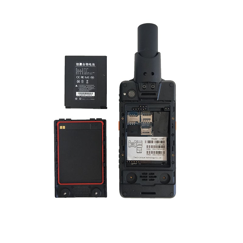
Hardware Design and Chipset Capability
Receiver Chipset and Processing Engine
At the core of every high accuracy handheld GPS device is a GNSS chipset that handles satellite signal acquisition, tracking, and position computation. The processing engine's capacity—measured in channels, tracking loops, and computational algorithms—directly determines how well the device performs under challenging conditions. More advanced chipsets can simultaneously track hundreds of signal channels across multiple constellations and frequencies.
The quality of the positioning engine's carrier phase tracking and ambiguity resolution algorithms is what separates high-precision chipsets from standard consumer-grade alternatives. Professional-grade receivers use sophisticated algorithms to maintain lock on signals even in degraded environments, enabling faster RTK initialization and more stable fixed solutions.
Thermal stability is another aspect of chipset performance that is often overlooked. Temperature variations in field conditions can introduce oscillator drift and timing errors in lower-quality receivers. Premium high accuracy handheld GPS chipsets include temperature-compensated oscillators and calibration routines to maintain timing stability across a wide operating temperature range.
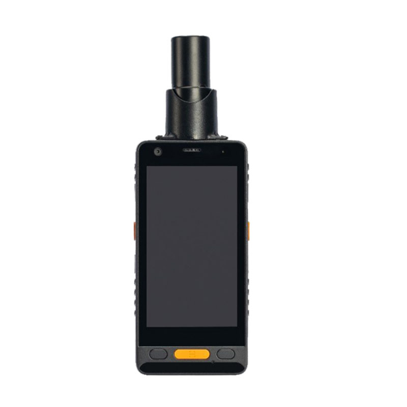
Antenna Quality and Placement
The antenna is the first point of contact between the device and the satellite signals, making its quality a critical determinant of overall performance. Antenna gain pattern, phase center accuracy, and low-noise amplifier quality all contribute to how cleanly the receiver can acquire and track satellite signals. In handheld applications, the antenna must be compact, but still designed to minimize phase center variation.
Phase center consistency is particularly important for a high accuracy handheld GPS system because any variation in the phase center location introduces systematic error into the positional solution. High-quality antennas maintain consistent phase centers across all tracked frequencies and elevation angles, contributing to repeatable and reliable centimeter-level measurements.
How the antenna is positioned on the device and how the device is held during measurement also matters in practice. Tilt compensation technology, found in more advanced handheld receivers, uses an internal IMU to correct for off-vertical antenna positions, allowing measurements to be taken without requiring the pole to be perfectly plumb. This improves both accuracy and field efficiency simultaneously.
Operational Practices and Field Setup
Initialization Time and Observation Duration
The amount of time a high accuracy handheld GPS device is allowed to observe satellite signals before a position is recorded has a direct impact on accuracy. For RTK solutions, initialization time is the period needed to resolve carrier phase ambiguities. Rushing this process or moving the device before initialization is complete can result in degraded or incorrect positions.
In post-processed applications, longer observation times average out random errors and reduce the impact of multipath and atmospheric noise. Even for real-time RTK workflows, allowing a few additional seconds of stability before recording each point adds a layer of quality assurance that is especially valuable in difficult signal environments.
Field operators should be trained to understand quality indicators on the device display, such as PDOP values, fix status, and estimated accuracy readouts. Acting on this information—waiting for better geometry or moving to a clearer sky view—directly improves the quality of collected data and reduces the need for resurveying.
Coordinate Systems and Datum Configuration
Even the most capable high accuracy handheld GPS device will produce misleading results if it is configured with the wrong coordinate system or datum. Positional data computed in WGS84 must often be transformed to a local geodetic datum to align with existing project data or national mapping standards. Errors in datum transformation parameters can introduce systematic offsets that undermine the entire dataset.
Field teams should confirm that their device is configured with the correct projection, datum, and geoid model before beginning data collection. Geoid undulation values affect the conversion between ellipsoidal height and orthometric (mean sea level) height, which matters greatly for elevation-critical applications such as drainage design, flood mapping, or volumetric calculation.
Regular communication between field operators and office-based GIS or surveying staff helps ensure that configuration settings remain consistent across devices and projects. Even a minor discrepancy in datum settings can cause expensive rework, so verification at the start of each project session is a best practice that pays dividends in data quality.
FAQ
What level of accuracy can a high accuracy handheld GPS achieve?
With RTK corrections and good satellite geometry, a professional high accuracy handheld GPS receiver can achieve horizontal accuracy at the centimeter level—typically in the range of 1 to 3 centimeters. Without corrections, or in challenging environments, accuracy may range from decimeter to sub-meter level depending on the device and conditions.
Does weather affect high accuracy handheld GPS performance?
Yes, atmospheric conditions such as heavy rain, extreme humidity, and solar storm activity can degrade signal quality and introduce additional positioning errors. However, dual-frequency high accuracy handheld GPS receivers are considerably more resilient to ionospheric disturbances than single-frequency units, making them the preferred choice for professional fieldwork.
How important is the correction data source for achieving high accuracy?
The correction data source is critically important. A high accuracy handheld GPS device can only deliver centimeter-level results if it receives high-quality, low-latency correction data from a nearby base station or a well-maintained network RTK service. Poor or absent corrections limit the device to its standalone positioning capability, which is far less precise.
Can tilt compensation improve the practical accuracy of a handheld GPS?
Yes, tilt compensation using an integrated IMU allows a high accuracy handheld GPS to record precise positions even when the survey pole is not perfectly vertical. This eliminates a common source of operator-induced error and speeds up fieldwork in areas where leveling is difficult. It is a particularly valuable feature for dense vegetation, slopes, and hard-to-access measurement points.