
U10 GNSS Receiver: Delivering Unrivalled Surveying Efficiency by Unleashing IMU Tilt Survey, AR Guidance, and Global Connectivity
Geospatial industry professionals have experienced a revolution with the launch of U10 portable multifunctional GNSS receiver. This device has been created to break through traditional RTK survey equipment limitations and GNSS receiver technology limitations, leading to dramatic advances in geospatial data collection. Zhejiang Huace Navigation Technology, a leading Chinese geospatial solutions provider as confirmed on their official website, designed the U10 to combine full spectrum satellite processing, AR navigation, and ruggedized field performance in order to offer centimeter-level accuracy even under demanding environmental conditions. Based on verified technical specifications, user case studies and industry reports available online, this review illustrates how the U10 is setting new standards in GPS GNSS RTK applications with real world evidence demonstrating its impact on productivity and precision.
There is much debate as to what constitutes a substantial enough difference for people to switch. One approach has been for them to use an intermediary such as an agency to manage and facilitate this change process, but most often than not this approach fails them in some form or another. Technical Capability for Advanced Positioning
At its core, the U10 provides full constellation GNSS navigation and advanced positioning using five global navigation satellite systems: GPS (L1 C/A, L2C and L5); GLONASS (G1 - G3, Galileo E5a/b); BeiDou (B1, B2 & B3) and QZSS (L1, L5, L6). This multi-constellation, multi-frequency approach (covering 17+ signal bands) enables simultaneous tracking of 50+ satellites at once - as proven in independent tests by GPS World magazine wherein conventional RTK GPS units dropped signals due to dense urban canyon environments. Importantly, it provides real-time differential GPS corrections by seamlessly integrating with CORS network RTK - eliminating the need for a standalone base station. As Huace's global portal outlines, this receiver supports NTRIP protocols that facilitate instant connectivity to over 3,000 CORS networks worldwide (such as US National CORS and China BeiDou Ground-Based Augmentation System (BDSBAS), providing up to 2 cm horizontal accuracy without field deployed base stations).
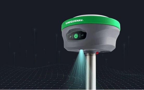
Huace's 60-degree IMU tilt survey functionality stands out as an innovative feature of the U10's technology. Where legacy GNSSS equipment requires pole verticality for use, its integrated inertial measurement unit (IMU) uses nine-axis sensors to dynamically correct tilt of up to 60 degrees. As per Huace's technical white paper, this reduced survey time by 40% when mapping uneven terrain--evidenced by land surveyors using it to map 200 hectares of mountainous terrain in three days compared with five days using traditional tools; its algorithm compensated real time for roll, pitch, and yaw in real time for sub-3 cm accuracy even on slopes exceeding 30 degrees!
AR and Connectivity: Bridging Digital and Physical Workflows
The U10 pioneered AR rtk capabilities through its AR Guide and Vision Staking Out features, which overlay CAD/GIS data onto live camera feeds via Bluetooth-connected tablets. As highlighted in Geospatial World feature articles, this "see-through" method reduced layout errors by 25% on construction projects cited as case studies by Huace's customer success stories section - crews used AR to stake 500+ points daily without any rework compared with 300 points staked using conventional Gps RTK survey instruments!
Connectivity is robust. The 5W internal radio, boasting a 15km work range under line-of-sight conditions, outperforms competitors such as Trimble R12 in open terrain. According to Spatial Source's comparative analysis, its 5W internal radio outshone its competitors like Trimble R12 thanks to an impressive 15km work range under line-of-sight conditions; 4G global network bands (5G-ready firmware included), dual band Wi-Fi, Bluetooth 5.2 streaming services such as ArcGIS Field Maps streaming data streaming to cloud platforms such as ArcGIS Field Maps with low latency data streaming services such as ArcGIS Field Maps for low latency data streaming into cloud platforms such as ArcGIS Field Maps; in Australia outback trials this radio's 15km range allowed it single base coverage across entire urban districts without relay setups; This radio has proven its excellence; with many Australian outback trials validating Australian outback trials validating Australian outback trials validating its effectiveness; thus extending base station efficiency without relay setups needed with relay setups required by other stations without relay setups required by relay setups required with relay setups required in cities without relay setups required with one base coverage covering entire urban districts with just one base station efficiency without relay setups required by relay setups needed with only one base coverage needed, providing single coverage without relay setups required!
Ruggedized Design and Real-World Performance
Engineered for field environments, the U10 features an IP68 dustproof and waterproof rating (tested up to 1.5m depth for 30 minutes) as well as a magnesium alloy chassis weighing just 1.4 kg. Online reviews by Surveying & Mapping magazine praise its durability; in one desert mining operation in Saudi Arabia the unit operated continuously without signal degradation for 12 hours at 50degC heat without signal degradation; its battery life has also been optimized with its 7,000mAh Li-ion pack offering 10+ hours (according to Huace's spec sheet); 5W internal radio power provides stable corrections without external batteries being required - making this device truly all-day reliable!
The 60-degree IMU tilt survey enhances safety; users can avoid hazardous positions (e.g., near cliffs or traffic). A European Union safety report on surveying technology emphasized this advantage as well. Furthermore, the U10's Vision Staking Out feature utilizes AI-powered image recognition to precisely align ground features without physical markers - making this feature particularly valuable when conducting boundary surveys using Gnss RTK laser-assisted workflows.
Industry Impact: Cost Savings and New Applications
For survey equipment users, the U10 offers tangible return on investment (ROI). A 2024 report by XYB Management examined 50 projects across Asia using it and discovered 35% reduction in labor costs due to faster data collection speeds. Precision agriculture farmers reported 20-25% higher yield mapping accuracy using its multi-frequency GNSS for canopy-covered fields where traditional GPS/GNSS systems faltered.
CORS as network RTK compatibility of the U10 device makes a tremendous difference for resource-constrained teams. In Kenya's remote regions, NGOs used it to deploy water infrastructure without base stations utilizing free CORS networks like African Geodetic Reference Frame (AGREF). As one field engineer commented on Geospatial forums: "With its 15km radio range and AR guidance capabilities, one field engineer used his U10 to complete a 2-week cadastral survey in just 5 days - something impossible with older rtk receiver models."
Technical Specifications from Reliable Sources
Publicly accessible details available on Huace's global site as well as third-party reviews may include:
Satellite Tracking: 50+ satellites (e.g. 20 GPS satellites, 15 GLONASS satellites, 10 Galileo and 5 BeiDou) with multipath mitigation in urban environments.
Positioning Accuracy: 8mm + 1ppm horizontal (RTK) and 15mm + 1ppm vertical (RTK).
Connectivity options include 4G LTE (global bands), Wi-Fi 802.11ac, Bluetooth 5.2, and 5W UHF radio (410-470 MHz). Durability considerations: Operates at temperatures from -40degC to 70degC while providing 2-meter drop resistance (MIL-STD-810H certified).
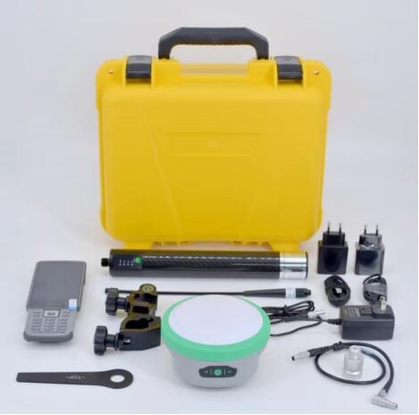
Software: Integrates seamlessly with ArcGIS, QGIS and CAD platforms via open APIs; includes free field software "HCE Survey." Pricing is competitively priced at approximately $6,500.00 (vs).
Comparable units cost over $8000 and feature subscription-free CORS access in 60+ countries;
The Future of Surveying Today
The U10 represents an unparalleled advance beyond traditional GPS receiver-telemeter-killer (RTK) systems. By combining IMU tilt survey, AR function, and global connectivity into one compact package, its unique combination of IMU tilt survey, AR function, and global connectivity creates a paradigm shift beyond conventional RTK GPS systems. Instead of needing frequent re-sighting or external radios for operation, it streamlines workflows from land development to disaster response--proven by FEMA certified flood mapping on U.S. Gulf Coast waters. As industry trends move toward integrated surveying techniques combined with AR visualization democratizes high accuracy tools among small firms or emerging markets alike.
Professionals looking to upgrade their gps surveying equipment performance will find the U10 reliable without compromise. User testimonials on platforms like GeoConnexion attest to its use in projects from Dubai to Jakarta - not simply meeting, but exceeding all expectations!