Understanding the Evolution of Precision Navigation Systems
The landscape of global positioning technology has undergone remarkable transformations since the introduction of GPS in the 1970s. Today, GNSS RTK represents a quantum leap forward in precision positioning capabilities, offering centimeter-level accuracy that transforms how we approach navigation, surveying, and countless industrial applications. This revolutionary technology combines the power of Global Navigation Satellite Systems (GNSS) with Real-Time Kinematics (RTK) to deliver unprecedented accuracy in position determination.
By integrating signals from multiple satellite constellations and utilizing sophisticated correction algorithms, GNSS RTK has become the gold standard for precise positioning in numerous professional fields. The technology's ability to provide real-time, highly accurate position data has opened new possibilities across industries, from precision agriculture to autonomous vehicles.
Core Components of GNSS RTK Systems
Base Station Infrastructure
At the heart of GNSS RTK technology lies the base station, a fixed reference point with precisely known coordinates. This station continuously monitors satellite signals and calculates corrections needed to achieve high precision. The base station tracks changes in atmospheric conditions, satellite orbits, and other variables that could affect positioning accuracy, ensuring the system maintains its high level of precision throughout operation.
Modern GNSS RTK base stations are equipped with advanced receivers capable of tracking multiple satellite constellations simultaneously. This multi-constellation capability significantly improves the system's reliability and accuracy, particularly in challenging environments where satellite visibility might be limited.
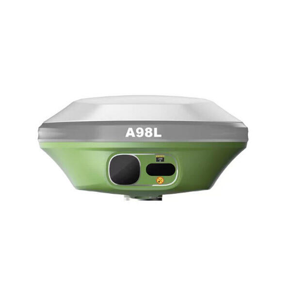
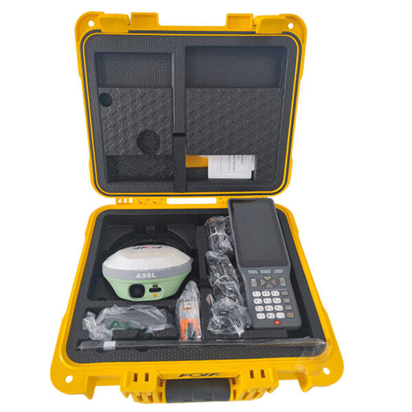
Rover Units and Mobile Applications
The rover represents the mobile component of GNSS RTK systems, receiving both satellite signals and correction data from the base station. These units have evolved from bulky equipment to compact, user-friendly devices that can be integrated into various applications. Modern rovers incorporate sophisticated processing capabilities to handle complex calculations in real-time, delivering precise positioning information to the end user.
The integration of GNSS RTK technology into mobile applications has democratized access to high-precision positioning. Surveyors, construction teams, and agricultural operators can now access centimeter-level accuracy through user-friendly interfaces on their mobile devices, streamlining workflows and improving operational efficiency.
Technical Principles Behind GNSS RTK Operation
Carrier Phase Measurements
GNSS RTK achieves its remarkable precision through carrier phase measurements, a sophisticated technique that tracks the phase of the carrier signal from satellites. Unlike standard GPS that primarily relies on code measurements, GNSS RTK technology measures the number of carrier wave cycles between the satellite and receiver, enabling much higher precision in position determination.
The system continuously monitors these carrier phases, resolving ambiguities in real-time to maintain accurate positioning. This process requires complex algorithms and high-quality receivers capable of tracking multiple satellite signals simultaneously while maintaining phase lock.
Real-Time Correction Processing
The real-time aspect of GNSS RTK technology involves sophisticated data processing and communication systems. Correction data from the base station must be transmitted to rovers with minimal latency, ensuring that position solutions remain accurate and current. This process involves handling large amounts of data and performing complex calculations in real-time.
Modern GNSS RTK systems employ advanced error modeling techniques to account for various sources of positioning errors, including atmospheric effects, satellite orbit uncertainties, and multipath interference. These corrections are continuously updated and applied to ensure optimal accuracy under varying conditions.
Industry Applications and Impact
Precision Agriculture Revolution
The agricultural sector has embraced GNSS RTK technology as a cornerstone of precision farming practices. Farmers utilize this technology for automated guidance systems, precise planting and harvesting operations, and optimized field management. The centimeter-level accuracy enables reduced overlap in field operations, leading to significant savings in time, fuel, and resources.
Advanced agricultural applications of GNSS RTK include variable rate application of inputs, automated section control, and precise documentation of field operations. These capabilities have revolutionized modern farming, improving efficiency while reducing environmental impact through more precise resource utilization.
Construction and Surveying Advancements
In construction and surveying, GNSS RTK technology has transformed traditional workflows by enabling rapid, accurate positioning and measurement. Surveyors can complete complex measurements in fraction of the time required by conventional methods, while construction teams can precisely position equipment and materials according to design specifications.
The technology's real-time capabilities allow for immediate verification of work quality and progress monitoring, reducing errors and improving project efficiency. Modern construction sites increasingly rely on GNSS RTK for machine control systems, enabling automated grading and excavation with unprecedented precision.
Future Developments and Trends
Integration with Emerging Technologies
The future of GNSS RTK technology is closely tied to its integration with other emerging technologies. The combination of RTK positioning with artificial intelligence and machine learning algorithms promises to enhance system reliability and accuracy further. These advanced systems will be capable of adapting to changing environmental conditions and optimizing performance automatically.
Integration with 5G networks and edge computing infrastructure will enable faster data transmission and processing, potentially reducing latency and improving real-time performance. This evolution will support more demanding applications, particularly in autonomous systems and smart city infrastructure.
Expanding Accessibility and Applications
As GNSS RTK technology continues to evolve, we're seeing a trend toward greater accessibility and broader application possibilities. Miniaturization of components and reduced costs are making high-precision positioning available to a wider range of users and industries. This democratization of precise positioning technology is driving innovation in unexpected areas, from urban planning to environmental monitoring.
The development of new satellite constellations and modernization of existing ones will further enhance GNSS RTK capabilities. Improved signal strength, additional frequencies, and better coverage will contribute to more robust and reliable positioning solutions, particularly in challenging environments.
Frequently Asked Questions
What accuracy level can be achieved with GNSS RTK technology?
GNSS RTK technology typically delivers centimeter-level accuracy, with horizontal accuracies of 1-2 centimeters and vertical accuracies of 2-3 centimeters under optimal conditions. This level of precision can be maintained in real-time, making it suitable for various high-precision applications.
How does GNSS RTK differ from standard GPS?
While standard GPS typically provides accuracy in meters, GNSS RTK achieves centimeter-level accuracy through the use of carrier phase measurements and real-time corrections from base stations. It also utilizes multiple satellite constellations rather than relying solely on GPS satellites.
What are the main limitations of GNSS RTK technology?
GNSS RTK requires good satellite visibility, a stable communication link between base and rover, and relatively clear sky view for optimal performance. Environmental factors such as heavy tree cover, urban canyons, or electromagnetic interference can impact system performance. Additionally, the initial cost of professional-grade equipment can be significant.
How far can a rover operate from the base station?
The effective range between a GNSS RTK base station and rover typically extends up to 20-30 kilometers under ideal conditions. However, accuracy may decrease with distance, and local conditions such as terrain and atmospheric effects can impact the practical working range.