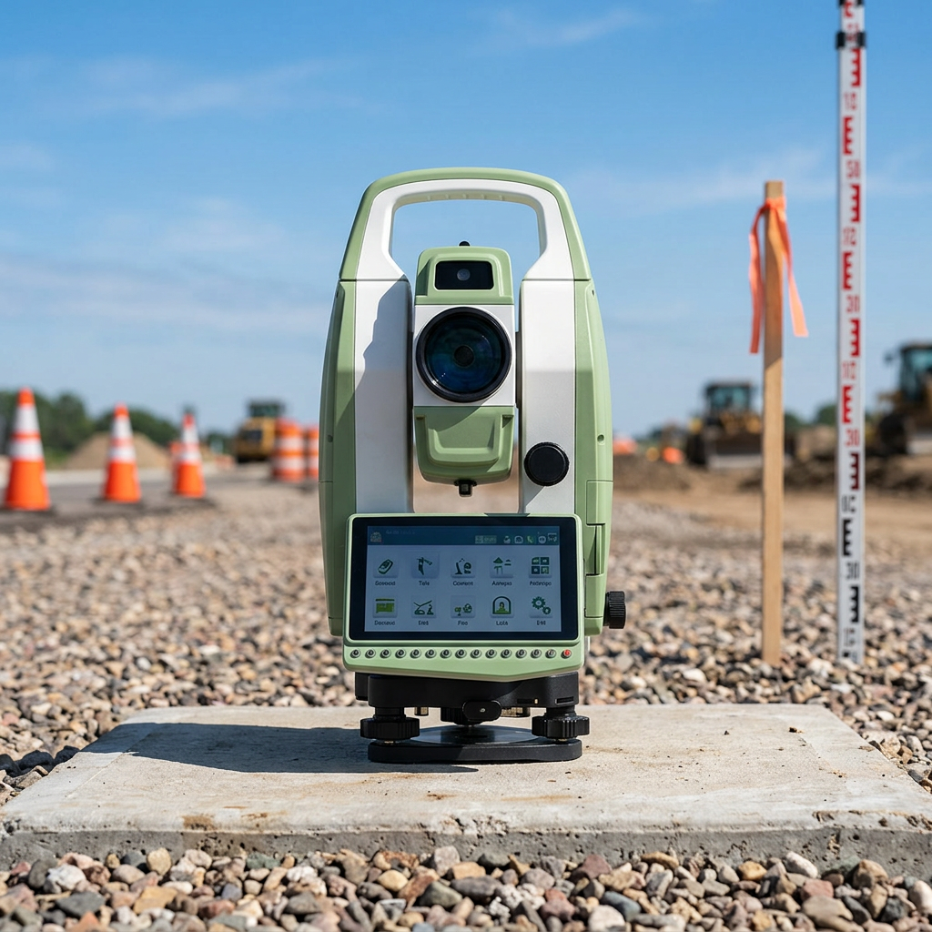
How Android Total Stations Enhance Surveying Accuracy
Precision Through Integrated GNSS and EDM Technology
The Android Total Station is changing how surveys get done these days thanks to built-in GNSS and EDM tech that delivers really accurate measurements. GNSS basically gives surveyors their exact location in real time, which matters a lot when conditions keep shifting around on site. Then there's EDM technology that measures distances down to the millimeter mark something that just wasn't possible with older techniques. According to some industry research, combining GNSS and EDM capabilities in these stations boosts accuracy somewhere between 10 and 30 percent. That kind of improvement makes all the difference for big projects where getting measurements right is absolutely critical, like when cities are planning new developments or infrastructure upgrades.
Automated Error Correction for Reliable Data
Automated error correction plays a big part in keeping data reliable for field operations. The system works by fixing measurement problems that come from weather changes or equipment malfunctions. Take Android Total Stations for instance they have built in algorithms that actually improve how accurate readings turn out. Field workers really appreciate this when working on large scale infrastructure jobs where even small mistakes can cause major headaches later on. Many professionals report better results after implementing these corrections, since random errors get caught before they become bigger issues. At the end of the day, cleaner data means fewer rework hours and more trustworthy measurements overall.
Software Integration for Seamless Workflows
BIM/CAD Compatibility for Unified Project Management
When BIM and CAD software work together, they really boost how projects get managed on site. Pairing them with Android Total Stations makes things much clearer for everyone involved. The visualization aspect becomes way better, so designers can see exactly what's going on in real world conditions. Surveyors no longer have to wait days for feedback from engineers because data flows between departments almost instantly. We've seen cases where mistakes caught early saved weeks of rework at construction sites. Most contractors now run their workflows through platforms like Autodesk Revit and AutoCAD. These tools let changes propagate across all documentation automatically. Some companies report cutting down unexpected delays by around 30% when everything syncs properly. The time savings alone often justify the investment in integrated systems.
GIS Tools for Advanced Spatial Analysis
When GIS gets integrated into Android Total Stations, it gives users powerful new ways to analyze spatial data something that matters a lot in areas such as urban development projects or tracking changes in ecosystems over time. The combination makes measurements much more accurate and helps professionals make better choices based on real world conditions rather than guesswork. Take ESRI's ArcGIS software for instance this works alongside those surveying devices to offer cool features like stacking different layers of geographic information together or asking questions about specific locations within datasets. These kinds of enhancements lead to better results on construction sites, environmental assessments, and other mapping related tasks where understanding space relationships is critical.
Real-Time Data Accessibility and Collaboration
Cloud Synchronization for Instant Data Access
Cloud sync brings some serious benefits for field survey crews. When teams can share data instantly through the cloud, everyone stays on the same page no matter where they are working from. The information remains current and available to whoever needs it next. This kind of consistency really helps when making decisions together and working as a team. Surveyors using platforms such as Google Cloud or AWS find their workflow much smoother since they don't have to wait for files to transfer or worry about losing updates. Just think about how many hours get wasted waiting for emails or dealing with version control issues before cloud solutions became standard practice.
Field-to-Office Communication Protocols
Effective communication between field and office staff is crucial for project efficiency. Modern protocols, such as video calls and shared virtual workspaces, facilitate quicker updates and informed decision-making. Using instant messaging platforms like Slack with Android Total Stations improves synchronization between stakeholders, reducing surveying errors and enhancing productivity.
User Interface Innovations for Efficiency
Intuitive Touchscreen Navigation
Touchscreen interfaces in Android Total Stations provide user-friendly interaction, minimizing the learning curve and enhancing field efficiency. Compared to traditional button interfaces, touchscreen technology offers a customizable, responsive experience, contributing to workflow improvements and faster task execution.
Mobile App Integration (BYOD Flexibility)
The BYOD concept allows surveyors to use personal mobile devices with Android Total Stations, fostering flexibility in data handling. Mobile apps enable efficient, real-time data management and accessibility, boosting field productivity through instant updates and accurate data capture. This integration highlights the growing influence of mobile technologies in surveying.
Productivity Gains in Field Operations
Reduced Setup Time with Robotic Automation
Robotic automation in Android Total Stations reduces setup time significantly, enhancing field productivity. By automating traditionally manual processes, these stations improve precision and efficiency, with industry benchmarks showing a 50% reduction in setup time, which accelerates survey projects.
Single-Operator Efficiency in Complex Environments
Advancements in Android Total Stations empower a single operator to effectively survey complex environments. Utilizing sophisticated AI frameworks and machine learning algorithms, these stations increase single-operator efficiency and reduce the need for additional personnel, illustrating significant implications for autonomous surveying operations.
FAQ
How do Android Total Stations improve surveying accuracy?
They integrate GNSS and EDM technologies, offering superior precision and enhancing error correction for reliable data.
What software integrations are advantageous for use with Android Total Stations?
Integrations with BIM/CAD software like Autodesk Revit and GIS tools like ArcGIS improve project management and spatial analysis.
How do modern communication protocols benefit survey teams?
They improve field-to-office collaboration through real-time updates and decision-making, boosting project efficiency.
What productivity gains are achieved through Android Total Stations?
Gains include reduced setup time through robotic automation and increased single-operator efficiency in complex environments.