Total Station Surveying Instrument: Advanced Precision Measurement Technology for Professional Surveyors

All Categories

total station surveying instrument

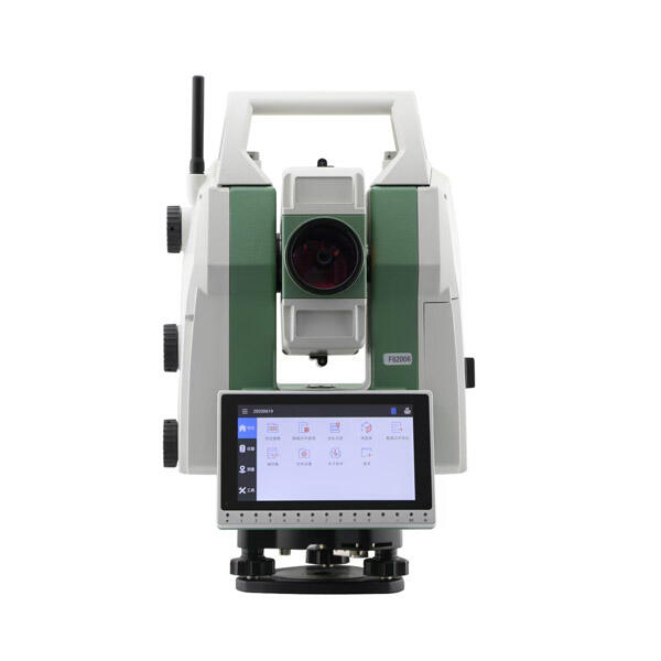
A total station surveying instrument represents a revolutionary advancement in modern surveying technology, combining electronic distance measurement with angular measurement capabilities in a single, integrated system. This sophisticated device incorporates electronic theodolite functionality with an electronic distance meter (EDM), enabling surveyors to determine both horizontal and vertical angles, as well as slope distances from a single setup position. The instrument features a microprocessor, electronic data collector, and storage system, allowing for immediate data processing and recording in the field. Modern total stations are equipped with advanced features such as automatic target recognition, remote control capabilities, and integrated GPS technology. These instruments can measure distances with millimeter-level accuracy and angles with precision down to one second of arc. The device operates by emitting infrared electromagnetic waves to a target prism or reflective surface, measuring the time taken for the signal to return, and calculating the distance. Total stations find extensive applications in construction layout, topographic mapping, road design, building construction, and infrastructure development projects. They excel in situations requiring precise measurements and are particularly valuable in challenging environments where traditional surveying methods might prove inadequate or time-consuming.

New Product Releases

The total station surveying instrument offers numerous practical advantages that make it an indispensable tool for modern surveying work. First and foremost, it significantly reduces the time required for field measurements by combining multiple functions in a single device. Surveyors can collect comprehensive data about distance, angles, and coordinates without switching between different instruments. The automated data collection and storage capabilities eliminate manual recording errors and provide instant digital records that can be easily transferred to computers for further processing. The instrument's high precision and accuracy levels ensure reliable measurements even in challenging conditions, reducing the need for repeated measurements and minimizing human error. Total stations feature user-friendly interfaces that make them accessible to operators with varying levels of experience, while still maintaining professional-grade capabilities. The ability to work in various weather conditions and lighting situations increases productivity and extends the practical working hours. The instrument's remote operation capability enhances safety by allowing measurements in hazardous or difficult-to-reach locations. Cost-effectiveness is another significant advantage, as the initial investment is offset by reduced labor costs, increased productivity, and improved accuracy that minimizes expensive rework. The integration with modern software systems enables seamless data transfer and processing, making it easier to generate detailed reports and 3D models. These advantages combine to make the total station an essential investment for surveying professionals, construction companies, and engineering firms seeking efficient and accurate measurement solutions.

Latest News

What are the common error sources in GNSS RTK positioning and how to mitigate them?

21

Mar

What are the common error sources in GNSS RTK positioning and how to mitigate them?

View More
Auto Level vs. Digital Level: Choosing the Right Tool

21

Mar

Auto Level vs. Digital Level: Choosing the Right Tool

View More
How to choose the right RTK GNSS equipment?

22

Apr

How to choose the right RTK GNSS equipment?

View More
How to Choose a Total Station Suitable for Engineering Needs?

22

Apr

How to Choose a Total Station Suitable for Engineering Needs?

View More

Get a Free Quote

Our representative will contact you soon.
Email
Name
Company Name
Message
0/1000

total station surveying instrument

Advanced Measurement Technology

Advanced Measurement Technology

The total station's advanced measurement technology represents a quantum leap in surveying capabilities. At its core, the system utilizes high-precision electronic distance measurement (EDM) technology that can achieve accuracy levels of up to 1mm + 1ppm over several kilometers. This remarkable precision is achieved through sophisticated phase-shift measurement techniques and advanced error compensation algorithms. The instrument's dual-axis compensator automatically corrects for slight misleveling, ensuring accurate measurements even when the instrument isn't perfectly level. The integration of angle measurement sensors capable of reading to one second of arc provides unprecedented angular accuracy. This technology is further enhanced by automatic atmospheric correction features that account for temperature, pressure, and humidity variations, ensuring consistent accuracy across different environmental conditions. The system's ability to perform real-time coordinate calculations and transformations makes it an invaluable tool for complex surveying tasks.
Intelligent Data Management System

Intelligent Data Management System

The total station's intelligent data management system revolutionizes how surveying data is collected, stored, and processed. This sophisticated system features onboard memory capable of storing thousands of points, complete with detailed coding and attribute information. The data management functionality includes advanced filtering and sorting capabilities, allowing surveyors to organize information based on various parameters such as point types, time stamps, or project specifications. Real-time quality control features automatically flag potentially erroneous measurements, reducing the likelihood of costly mistakes. The system supports multiple data format exports, ensuring compatibility with various CAD and GIS software platforms. Built-in wireless connectivity enables immediate data transfer to external devices, facilitating real-time collaboration and project monitoring. The intelligent coding system allows for automated feature recognition and line work creation, significantly reducing post-processing time.
Versatile Field Applications

Versatile Field Applications

The total station's versatility in field applications sets it apart as an exceptional surveying tool. Its adaptability allows for seamless operation across diverse project types, from simple property surveys to complex infrastructure development. The instrument's robotic capabilities enable one-person operation, significantly reducing labor costs while maintaining high productivity levels. Advanced tracking technology allows the total station to automatically follow a moving prism, making dynamic measurements possible for applications such as machine control and deformation monitoring. The instrument's ability to operate in low-light conditions and adverse weather expands its practical use cases. Built-in scanning capabilities enable rapid data collection for as-built surveys and 3D modeling applications. The system's integration with GPS technology provides additional flexibility in establishing control points and performing coordinate transformations. This versatility makes it an ideal solution for construction layout, topographic surveys, volume calculations, and precise positioning tasks.