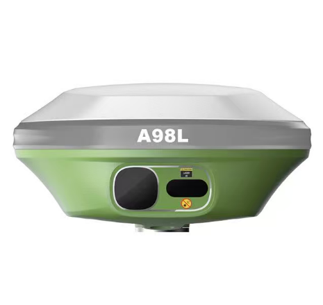
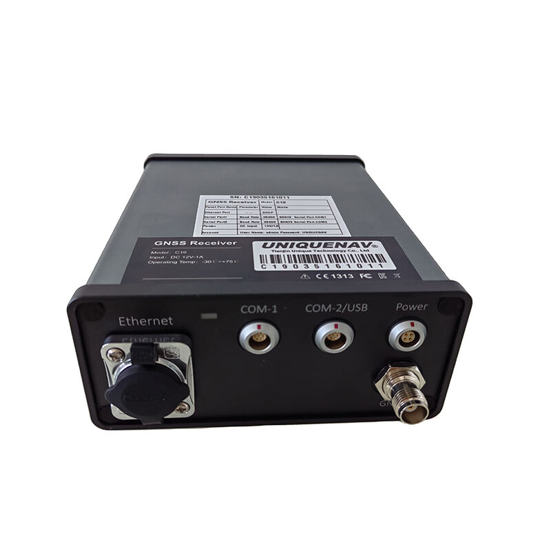
Low Cost RTK GNSS Systems - Affordable Precision Positioning Technology

All Categories

low cost rtk gnss

The low cost rtk gnss represents a revolutionary advancement in global navigation satellite systems that delivers centimeter-level positioning accuracy at an affordable price point. This innovative technology combines real-time kinematic positioning capabilities with cost-effective hardware solutions, making precision navigation accessible to a broader range of users and applications. Unlike traditional GNSS systems that provide meter-level accuracy, the low cost rtk gnss achieves remarkable precision through sophisticated differential correction techniques and enhanced signal processing algorithms. The system operates by establishing a base station at a known location that calculates correction data and transmits this information to mobile receivers, enabling them to achieve positioning accuracy within 1-2 centimeters horizontally and 2-3 centimeters vertically. Key technological features include multi-constellation support for GPS, GLONASS, Galileo, and BeiDou satellites, ensuring robust signal availability and improved reliability in challenging environments. The low cost rtk gnss incorporates advanced antenna designs, high-performance processors, and efficient power management systems that maintain operational excellence while reducing manufacturing expenses. Modern implementations feature wireless connectivity options including radio, cellular, and internet-based correction services, providing flexible deployment scenarios for various operational requirements. Primary applications span multiple industries including precision agriculture for automated machinery guidance, construction surveying for site layout and monitoring, drone operations requiring accurate flight path execution, and mapping projects demanding high-precision data collection. The technology proves invaluable for land surveying professionals who need reliable positioning data for boundary determination and topographic mapping. Emergency response teams utilize low cost rtk gnss systems for search and rescue operations where precise location tracking becomes critical for mission success. Scientific research applications benefit from the enhanced accuracy for geological studies, environmental monitoring, and infrastructure assessment projects that require detailed spatial data analysis.

New Products

The low cost rtk gnss delivers exceptional value through dramatically reduced equipment costs without compromising measurement precision or operational reliability. Traditional high-end RTK systems typically require substantial capital investments that often exceed budget constraints for smaller organizations and independent professionals. This affordable solution democratizes access to centimeter-level positioning technology, enabling small-scale farmers, local surveying companies, and educational institutions to leverage precision navigation capabilities previously reserved for large corporations. Implementation costs drop significantly because the low cost rtk gnss eliminates expensive proprietary components while maintaining professional-grade performance standards. Users experience immediate productivity gains through faster data collection processes and reduced field time requirements compared to conventional surveying methods. The technology streamlines workflow efficiency by providing real-time positioning data that eliminates the need for post-processing corrections and multiple site visits. Operational flexibility increases substantially as the low cost rtk gnss supports various correction delivery methods including internet-based services, radio transmission, and cellular networks, allowing users to select the most suitable option for their specific working conditions. Setup procedures become significantly simplified with user-friendly interfaces and automated configuration processes that reduce training requirements and minimize human error potential. Battery life optimization ensures extended field operations without frequent charging interruptions, while rugged construction withstands harsh environmental conditions including extreme temperatures, moisture exposure, and physical impacts. The system provides consistent performance across diverse terrains and weather conditions, maintaining accuracy standards regardless of operational challenges. Maintenance requirements remain minimal due to solid-state components and robust engineering designs that reduce wear-related failures and service intervals. Software integration capabilities allow seamless connectivity with existing workflow systems, GIS platforms, and data management applications, enhancing overall operational efficiency. Users benefit from regular firmware updates that introduce new features, improve performance, and expand compatibility with emerging technologies. The low cost rtk gnss supports multiple output formats ensuring compatibility with various professional software packages and industry-standard data exchange protocols. Scalability advantages enable organizations to expand their precision positioning capabilities gradually without major system overhauls or compatibility issues.

Latest News

How GNSS RTK Systems Deliver High-Precision Results

27

Nov

How GNSS RTK Systems Deliver High-Precision Results

Modern surveying and positioning applications demand exceptional accuracy that traditional GPS systems simply cannot deliver. Global Navigation Satellite System Real-Time Kinematic (GNSS RTK Systems) have revolutionized precision positioning by provi...
View More
What Should Engineers Check Before Choosing an RTK System?

22

Dec

What Should Engineers Check Before Choosing an RTK System?

Selecting the right RTK system represents one of the most critical decisions in modern surveying and construction projects. Engineers must navigate through numerous technical specifications, accuracy requirements, and operational considerations to en...
View More
Why Are Digital Levels Preferred Over Traditional Bubble Levels?

11

Feb

Why Are Digital Levels Preferred Over Traditional Bubble Levels?

The construction and engineering industries have witnessed a significant transformation in measurement tools over the past decade. Among these advancements, digital levels have emerged as the preferred choice for professionals who demand precision, e...
View More
How Does a Theodolite Compare to Total Stations in Practical Use?

11

Feb

How Does a Theodolite Compare to Total Stations in Practical Use?

Surveying professionals and construction engineers face critical decisions when selecting measurement instruments for their projects. The choice between traditional surveying tools and modern integrated systems can significantly impact project effici...
View More

Get a Free Quote

Our representative will contact you soon.
Email
Name
Company Name
Message
0/1000

low cost rtk gnss

Revolutionary Affordability Without Performance Compromise

Revolutionary Affordability Without Performance Compromise

The most compelling advantage of the low cost rtk gnss lies in its ability to deliver professional-grade centimeter-level accuracy at a fraction of traditional system costs. This breakthrough represents a fundamental shift in precision positioning technology accessibility, making advanced navigation capabilities available to users who previously could not justify the substantial investment required for high-end RTK solutions. The technology achieves this cost reduction through innovative manufacturing processes, streamlined component selection, and efficient system architectures that eliminate unnecessary complexity while preserving core functionality. Engineering teams have successfully identified and removed cost barriers that historically limited RTK adoption, including expensive proprietary processors, specialized antenna systems, and complex calibration procedures. The result enables small agricultural operations to implement precision farming techniques, local construction companies to perform accurate site surveys, and educational institutions to provide hands-on training with professional equipment. Cost savings extend beyond initial purchase prices to include reduced operational expenses through lower maintenance requirements, simplified training needs, and decreased field time investments. Users typically recover their equipment costs within months through improved efficiency, reduced material waste, and enhanced project accuracy. The low cost rtk gnss maintains measurement precision standards that satisfy professional surveying requirements, regulatory compliance needs, and scientific research demands. Quality control processes ensure consistent manufacturing standards while competitive pricing strategies make the technology accessible to emerging markets and developing regions. This democratization of precision positioning technology stimulates innovation across multiple industries by enabling new applications, business models, and service offerings that were previously economically unfeasible. Organizations can now deploy multiple units for comprehensive coverage areas, implement redundant systems for critical operations, and provide equipment access to field personnel without significant budget constraints.
Exceptional Accuracy and Reliability Performance

Exceptional Accuracy and Reliability Performance

The low cost rtk gnss delivers remarkable positioning accuracy that rivals expensive professional systems while maintaining consistent performance across diverse operational environments and challenging conditions. This exceptional precision stems from advanced signal processing algorithms, sophisticated error correction techniques, and robust multi-constellation satellite tracking capabilities that ensure reliable centimeter-level measurements. The system achieves horizontal accuracy within 1-2 centimeters and vertical accuracy within 2-3 centimeters under optimal conditions, meeting or exceeding requirements for most professional applications including land surveying, construction layout, precision agriculture, and scientific research. Signal acquisition and tracking performance remains stable even in challenging environments such as urban canyons, dense forest canopies, and areas with electromagnetic interference, thanks to enhanced antenna designs and adaptive filtering technologies. The low cost rtk gnss incorporates multiple satellite constellation support including GPS, GLONASS, Galileo, and BeiDou systems, providing increased satellite visibility and improved geometric diversity for enhanced positioning solutions. Real-time correction processing ensures immediate availability of precise positioning data without post-processing delays that can impact productivity and workflow efficiency. The system maintains accuracy standards across extended operational periods through sophisticated drift compensation algorithms and environmental factor corrections that account for atmospheric conditions, satellite clock errors, and signal propagation delays. Quality indicators provide real-time feedback on measurement reliability, enabling users to assess data confidence levels and make informed decisions about survey point acceptance. Repeatability testing demonstrates consistent measurement results when returning to previously occupied positions, confirming system stability and calibration integrity. The technology handles rapid movement scenarios effectively, making it suitable for dynamic applications such as machinery guidance, vehicle tracking, and airborne surveys where positioning accuracy must be maintained during motion. Environmental durability ensures reliable operation across temperature extremes, humidity variations, and exposure to dust, water, and physical impacts that commonly occur in field conditions.
Versatile Integration and User-Friendly Operation

Versatile Integration and User-Friendly Operation

The low cost rtk gnss excels in providing seamless integration capabilities and intuitive operation that reduces complexity while expanding compatibility with existing systems and workflows. This user-centric design approach eliminates traditional barriers to RTK technology adoption by simplifying setup procedures, automating configuration processes, and providing flexible connectivity options that accommodate diverse operational requirements. The system features plug-and-play functionality that allows users to achieve operational status within minutes rather than hours typically required for complex professional systems. Intuitive software interfaces guide users through setup procedures with clear instructions, visual indicators, and automated diagnostics that identify and resolve common configuration issues. Multiple connectivity options including Bluetooth, Wi-Fi, cellular, and radio communication ensure compatibility with various devices, networks, and correction service providers, enabling users to select optimal solutions for their specific working environments. The low cost rtk gnss supports industry-standard data formats and communication protocols, facilitating integration with existing GIS software, CAD applications, survey programs, and data management systems without requiring extensive customization or additional software purchases. Real-time data streaming capabilities enable immediate integration with mapping applications, machinery control systems, and monitoring platforms for enhanced operational efficiency and decision-making capabilities. Mobile device compatibility through dedicated applications provides field personnel with comprehensive system control, data visualization, and project management tools accessible through smartphones and tablets. Cloud-based services offer remote monitoring, data backup, and system configuration management that enhances operational flexibility and data security. The system accommodates various correction service options including internet-based providers, local base stations, and network RTK services, allowing users to optimize accuracy, coverage, and cost considerations based on specific project requirements. Modular design concepts enable system expansion and customization through additional sensors, communication modules, and specialized accessories without requiring complete system replacement. Technical support resources include comprehensive documentation, video tutorials, online forums, and direct assistance channels that ensure users can maximize system capabilities and resolve operational challenges efficiently.

Get a Free Quote

Our representative will contact you soon.
Email
Name
Company Name
Message
0/1000