
A98L Laser Çift Kamera RTK, Daha Güvenli ve Akıllı Ölçme Çalışmalarına Öncülük Eden
A98L Laser Çift Kamera RTK, tam yıldız kümesi GNSS konumlandırma, yeşil lazer mesafe ölçümü, çift kamera AR aplikasyonu ve IMU ataletsel navigasyonu birleştiren yeni nesil entegre bir çözümdür. Yüksek riskli, ulaşılması zor ve temas yasağı bulunan senaryolar için tasarlanan A98L, temas gerektirmeyen, yüksek verimli ve yüksek doğruluklu saha ölçümü için yeni bir standart belirler.
1408 kanallı bir konumlandırma motoruyla çalışan A98L, BDS, GPS, GLONASS, Galileo, QZSS, NAVIC ve SBAS sistemlerinden gelen tam sistem ve tam frekans sinyallerini yanı sıra PPP hizmetlerini destekler. Standart güncelleme hızı 20 Hz, soğuk başlangıç süresi <12 saniye, ilk başlatma süresi <5 saniye ve güvenilirlik >%99,9 seviyesindedir; bu da yoğun ormanlık alanlarda ve karmaşık kentsel ortamlarda bile kararlı sabit çözümler sunmasını sağlar.
Cihazın kalbinde, 0,1–25 m ölçüm aralığına, saniyede en fazla 20 kez ölçüm yapabilme frekansına, 1 mm çözünürlüğe ve 10 m mesafede ±2 mm doğruluğa sahip 520 nm yeşil görünür lazer (Sınıf 3 güvenlik) yer alır. Yüksek görünürlüklü yeşil nokta, güçlü güneş ışığında bile net olarak görülebilir ve operatörleri tehlikelerden uzak tutarak tamamen temassız ölçüm yapılmasını sağlar.
Yüksek performanslı bir IMU modülüyle birlikte çalışan A98L, 2 cm’ye kadar doğrulukla 60° eğim ölçümü destekler; bu da hassas merkezleme gerektirmeden anında noktaya bakıp ölçüm yapma işlemini mümkün kılar. Çift 2 MP HD kamera (90° ön, 72° alt), uzun menzilli yönlendirme ile yakın menzilli merkezlemeyi birleştirerek genel verimliliği %39 oranında artıran AR destekli kazıklama işlemlerini sağlar.
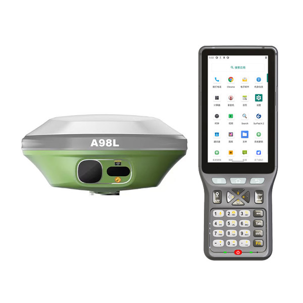
Zorlu saha koşulları için tasarlanan A98L, hafif ağırlıklı magnezyum-alüminyum alaşım gövdeye (ağırlık <900 g), IP67 su ve toz geçirmezlik derecelendirmesine, 2 m direk düşme dayanımına ve -30°C ile +70°C arasında çalışma sıcaklığı aralığına sahiptir. Büyük kapasiteli 13400 mAh pil, statik modda 18 saatten fazla, RTK modunda ise 12 saatten fazla çalışma süresi sağlar ve tüm gün boyu saha görevlerini destekler.
Bağlantı açısından cihaz, 8 GB dahili bellekli Linux işletim sistemiyle çalışır ve 4G, Wi-Fi, Bluetooth 5.0 ile 2 W’lık UHF radyoyu destekler. TrimTalk450s, Satel ve South gibi yaygın protokollere uyumludur; bu da çeşitli çalışma modlarında kararlı veri iletimini sağlar.
A98L, tehlikeli alanlar, kültürel miras siteleri, iskeleler ve köprüler, yoğun ormanlık alanlar, karayolu altyapısı ile su yolu ölçümleri gibi birçok uygulamada yaygın olarak kullanılır ve zorlu senaryolarda güvenli, verimli ve yüksek doğruluklu ölçüm imkânı sunar.