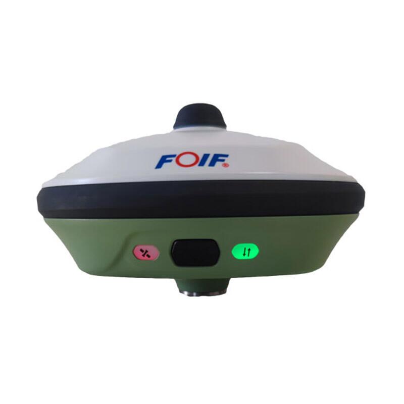
Professional Handheld GNSS Receiver: High-Precision Navigation Solution for Field Applications

All Categories

handheld gnss receiver

A handheld GNSS receiver represents a revolutionary advancement in navigation technology, combining precision positioning capabilities with portable convenience. This sophisticated device utilizes signals from multiple satellite constellations including GPS, GLONASS, Galileo, and BeiDou to determine exact locations with remarkable accuracy. Modern handheld GNSS receivers feature high-sensitivity antennas, powerful processors, and intuitive user interfaces that make navigation accessible to both professionals and enthusiasts. These devices typically offer comprehensive mapping capabilities, waypoint management, track recording, and route planning functions. The technology incorporates real-time positioning updates, elevation data, and the ability to store multiple coordinate systems. Advanced models include additional features such as electronic compasses, barometric altimeters, and wireless connectivity for data transfer. The durability of these devices is noteworthy, with many models featuring rugged construction, water resistance, and long battery life suitable for extended outdoor use. Applications span across numerous fields, from recreational activities like hiking and geocaching to professional uses in surveying, forestry, agriculture, and emergency response operations. The integration of modern touchscreen displays and user-friendly software makes complex navigation tasks straightforward and efficient.
New Product Recommendations

The handheld GNSS receiver offers numerous practical benefits that make it an indispensable tool for various applications. First and foremost, its portability allows users to carry professional-grade navigation capabilities anywhere, without being tethered to vehicles or fixed installations. The multi-constellation reception capability significantly improves accuracy and reliability, particularly in challenging environments where traditional GPS signals might be compromised. Users benefit from quick position acquisition and maintained accuracy even in areas with partial sky visibility. The device's versatility shines through its ability to store and manage multiple waypoints, routes, and tracks, enabling complex navigation tasks with ease. Battery efficiency has been optimized to provide extended field operation, often lasting several days with typical use. The robust construction ensures reliability in adverse weather conditions and rough handling, making it suitable for professional field work. Modern receivers feature intuitive interfaces that reduce the learning curve, allowing users to access advanced features without extensive training. Data management capabilities enable seamless integration with various mapping software and GIS systems, facilitating efficient workflow in professional applications. The ability to customize display settings, coordinate systems, and measurement units adds to its versatility across different use cases. These devices often include wireless connectivity options for real-time data sharing and updates, enhancing team coordination in professional settings. The combination of high accuracy, reliability, and user-friendly operation makes these devices valuable tools for both recreational and professional users.

Latest News

How to Set Up and Calibrate an Android Total Station?

21

Mar

How to Set Up and Calibrate an Android Total Station?

View More
What are the common error sources in GNSS RTK positioning and how to mitigate them?

21

Mar

What are the common error sources in GNSS RTK positioning and how to mitigate them?

View More
Auto Level vs. Digital Level: Choosing the Right Tool

21

Mar

Auto Level vs. Digital Level: Choosing the Right Tool

View More
What are the common error sources and solutions when using RTK GNSS?

22

Apr

What are the common error sources and solutions when using RTK GNSS?

View More

Get a Free Quote

Our representative will contact you soon.
Email
Name
Company Name
Message
0/1000

handheld gnss receiver

Superior Positioning Accuracy and Reliability

Superior Positioning Accuracy and Reliability

The handheld GNSS receiver sets new standards in positioning accuracy through its advanced multi-constellation reception capabilities. By simultaneously tracking signals from multiple satellite systems, including GPS, GLONASS, Galileo, and BeiDou, the device achieves exceptional position accuracy often within 2-3 meters under optimal conditions. This multi-system approach significantly reduces position errors caused by satellite geometry and signal obstacles. The receiver's high-sensitivity antenna design enables reliable performance even in challenging environments such as urban canyons or under dense forest canopy. Advanced signal processing algorithms continuously filter and validate satellite signals to maintain accuracy and eliminate potential sources of error. The device's ability to maintain consistent accuracy across different terrains and conditions makes it invaluable for applications requiring precise positioning.
Comprehensive Navigation Features and Interface

Comprehensive Navigation Features and Interface

The device's navigation capabilities extend far beyond basic positioning to include a comprehensive suite of features designed for professional and recreational users alike. The interface presents complex navigation data in an easily digestible format through a high-resolution color display with customizable data fields. Users can manage multiple waypoints, routes, and tracks with intuitive organization tools that simplify complex navigation tasks. The integrated mapping system supports various map formats and allows for real-time position overlay on detailed topographic maps. Advanced routing algorithms enable efficient path planning while considering terrain features and user-defined parameters. The electronic compass and barometric altimeter provide reliable orientation and elevation data even when stationary.
Robust Design and Field Reliability

Robust Design and Field Reliability

The handheld GNSS receiver is engineered to withstand demanding field conditions while maintaining optimal performance. The rugged construction typically includes impact-resistant housing, sealed buttons, and weatherproof design meeting military standards for durability. Battery management systems optimize power consumption while providing reliable operation for extended periods, often exceeding 16 hours of continuous use. The device's internal memory is protected against data loss, ensuring critical navigation information remains secure even in extreme conditions. Advanced thermal management systems maintain stable operation across a wide temperature range, from arctic cold to desert heat. The ergonomic design considers field use requirements, with easily accessible buttons and a non-slip grip surface for secure handling in wet conditions.